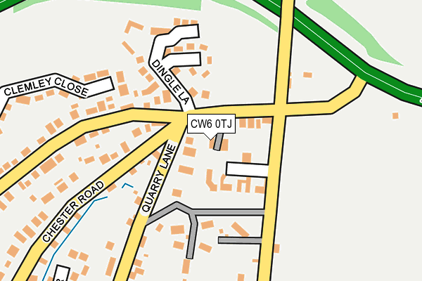
CW6 0TJ lies on Foresters View in Kelsall, Tarporley. CW6 0TJ is located in the Tarvin & Kelsall electoral ward, within the unitary authority of Cheshire West and Chester and the English Parliamentary constituency of Eddisbury. The Sub Integrated Care Board (ICB) Location is NHS Cheshire and Merseyside ICB - 27D and the police force is Cheshire. This postcode has been in use since July 2002.


GetTheData
Source: OS OpenMap – Local (Ordnance Survey)
Source: OS VectorMap District (Ordnance Survey)
Licence: Open Government Licence (requires attribution)
| Easting | 353206 |
| Northing | 368651 |
| Latitude | 53.212862 |
| Longitude | -2.702160 |
GetTheData
Source: Open Postcode Geo
Licence: Open Government Licence
| Street | Foresters View |
| Locality | Kelsall |
| Town/City | Tarporley |
| Country | England |
| Postcode District | CW6 |
➜ See where CW6 is on a map ➜ Where is Kelsall? | |
GetTheData
Source: Land Registry Price Paid Data
Licence: Open Government Licence
Elevation or altitude of CW6 0TJ as distance above sea level:
| Metres | Feet | |
|---|---|---|
| Elevation | 120m | 394ft |
Elevation is measured from the approximate centre of the postcode, to the nearest point on an OS contour line from OS Terrain 50, which has contour spacing of ten vertical metres.
➜ How high above sea level am I? Find the elevation of your current position using your device's GPS.
GetTheData
Source: Open Postcode Elevation
Licence: Open Government Licence
| Ward | Tarvin & Kelsall |
| Constituency | Eddisbury |
GetTheData
Source: ONS Postcode Database
Licence: Open Government Licence
2, FORESTERS VIEW, KELSALL, TARPORLEY, CW6 0TJ 2007 8 JUN £270,000 |
GetTheData
Source: HM Land Registry Price Paid Data
Licence: Contains HM Land Registry data © Crown copyright and database right 2025. This data is licensed under the Open Government Licence v3.0.
| Farmers Arms Ph (Chester Road) | Kelsall | 65m |
| Farmers Arms Ph (Chester Road) | Kelsall | 72m |
| Bramley Court (Chester Road) | Kelsall | 511m |
| Bramley Court (Chester Road) | Kelsall | 611m |
| Old Bank Surgery (Chester Road) | Kelsall | 937m |
| Mouldsworth Station | 2.9km |
| Delamere Station | 3km |
GetTheData
Source: NaPTAN
Licence: Open Government Licence
GetTheData
Source: ONS Postcode Database
Licence: Open Government Licence


➜ Get more ratings from the Food Standards Agency
GetTheData
Source: Food Standards Agency
Licence: FSA terms & conditions
| Last Collection | |||
|---|---|---|---|
| Location | Mon-Fri | Sat | Distance |
| Cheese Hill | 16:15 | 10:45 | 5,413m |
GetTheData
Source: Dracos
Licence: Creative Commons Attribution-ShareAlike
The below table lists the International Territorial Level (ITL) codes (formerly Nomenclature of Territorial Units for Statistics (NUTS) codes) and Local Administrative Units (LAU) codes for CW6 0TJ:
| ITL 1 Code | Name |
|---|---|
| TLD | North West (England) |
| ITL 2 Code | Name |
| TLD6 | Cheshire |
| ITL 3 Code | Name |
| TLD63 | Cheshire West and Chester |
| LAU 1 Code | Name |
| E06000050 | Cheshire West and Chester |
GetTheData
Source: ONS Postcode Directory
Licence: Open Government Licence
The below table lists the Census Output Area (OA), Lower Layer Super Output Area (LSOA), and Middle Layer Super Output Area (MSOA) for CW6 0TJ:
| Code | Name | |
|---|---|---|
| OA | E00092561 | |
| LSOA | E01018350 | Cheshire West and Chester 030B |
| MSOA | E02003800 | Cheshire West and Chester 030 |
GetTheData
Source: ONS Postcode Directory
Licence: Open Government Licence
| CW6 0SJ | Chester Road | 35m |
| CW6 0TB | Yeld Lane | 134m |
| CW6 0SH | Hillcrest Road | 143m |
| CW6 0SG | Dingle Lane | 178m |
| CW6 0SQ | Dingle Crescent | 211m |
| CW6 0RD | Clemley Close | 216m |
| CW6 0RA | Old Coach Road | 235m |
| CW6 0SE | Chester Road | 281m |
| CW6 0PD | Quarry Lane | 316m |
| CW6 0SD | Chester Road | 332m |
GetTheData
Source: Open Postcode Geo; Land Registry Price Paid Data
Licence: Open Government Licence