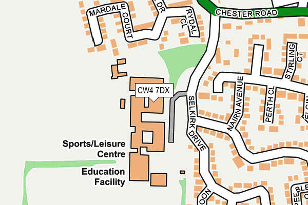
CW4 7DX is located in the Dane Valley electoral ward, within the unitary authority of Cheshire East and the English Parliamentary constituency of Congleton. The Sub Integrated Care Board (ICB) Location is NHS Cheshire and Merseyside ICB - 27D and the police force is Cheshire. This postcode has been in use since January 1980.


GetTheData
Source: OS OpenMap – Local (Ordnance Survey)
Source: OS VectorMap District (Ordnance Survey)
Licence: Open Government Licence (requires attribution)
| Easting | 375480 |
| Northing | 366815 |
| Latitude | 53.197843 |
| Longitude | -2.368495 |
GetTheData
Source: Open Postcode Geo
Licence: Open Government Licence
| Country | England |
| Postcode District | CW4 |
➜ See where CW4 is on a map ➜ Where is Holmes Chapel? | |
GetTheData
Source: Land Registry Price Paid Data
Licence: Open Government Licence
Elevation or altitude of CW4 7DX as distance above sea level:
| Metres | Feet | |
|---|---|---|
| Elevation | 60m | 197ft |
Elevation is measured from the approximate centre of the postcode, to the nearest point on an OS contour line from OS Terrain 50, which has contour spacing of ten vertical metres.
➜ How high above sea level am I? Find the elevation of your current position using your device's GPS.
GetTheData
Source: Open Postcode Elevation
Licence: Open Government Licence
| Ward | Dane Valley |
| Constituency | Congleton |
GetTheData
Source: ONS Postcode Database
Licence: Open Government Licence
| Holmes Chapel Comprehensive (Off Selkirk Drive) | Holmes Chapel | 57m |
| Brookfield Drive (Chester Road) | Holmes Chapel | 292m |
| Brookfield Drive (Chester Road) | Holmes Chapel | 299m |
| Shopping Precinct (London Road) | Holmes Chapel | 824m |
| Shopping Precinct (London Road) | Holmes Chapel | 840m |
| Holmes Chapel Station | 1.2km |
| Goostrey Station | 3.9km |
GetTheData
Source: NaPTAN
Licence: Open Government Licence
GetTheData
Source: ONS Postcode Database
Licence: Open Government Licence


➜ Get more ratings from the Food Standards Agency
GetTheData
Source: Food Standards Agency
Licence: FSA terms & conditions
| Last Collection | |||
|---|---|---|---|
| Location | Mon-Fri | Sat | Distance |
| Brookfield Drive | 17:35 | 09:00 | 328m |
| Westway | 17:30 | 09:00 | 354m |
| Coniston Drive | 17:45 | 09:00 | 406m |
GetTheData
Source: Dracos
Licence: Creative Commons Attribution-ShareAlike
The below table lists the International Territorial Level (ITL) codes (formerly Nomenclature of Territorial Units for Statistics (NUTS) codes) and Local Administrative Units (LAU) codes for CW4 7DX:
| ITL 1 Code | Name |
|---|---|
| TLD | North West (England) |
| ITL 2 Code | Name |
| TLD6 | Cheshire |
| ITL 3 Code | Name |
| TLD62 | Cheshire East |
| LAU 1 Code | Name |
| E06000049 | Cheshire East |
GetTheData
Source: ONS Postcode Directory
Licence: Open Government Licence
The below table lists the Census Output Area (OA), Lower Layer Super Output Area (LSOA), and Middle Layer Super Output Area (MSOA) for CW4 7DX:
| Code | Name | |
|---|---|---|
| OA | E00092927 | |
| LSOA | E01018414 | Cheshire East 023B |
| MSOA | E02003812 | Cheshire East 023 |
GetTheData
Source: ONS Postcode Directory
Licence: Open Government Licence
| CW4 7JR | Rydal Close | 170m |
| CW4 7JP | Mardale Court | 173m |
| CW4 7JL | Nairn Avenue | 179m |
| CW4 7JW | Grasmere Drive | 182m |
| CW4 7JQ | Balmoral Drive | 187m |
| CW4 7JJ | Montrose Court | 213m |
| CW4 7LL | Dunoon Close | 221m |
| CW4 7LJ | Selkirk Drive | 231m |
| CW4 7JS | Cartmel Close | 235m |
| CW4 7DR | Chester Road | 240m |
GetTheData
Source: Open Postcode Geo; Land Registry Price Paid Data
Licence: Open Government Licence