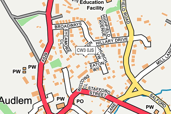
CW3 0JS lies on Cotton Mews in Audlem, Crewe. CW3 0JS is located in the Audlem electoral ward, within the unitary authority of Cheshire East and the English Parliamentary constituency of Eddisbury. The Sub Integrated Care Board (ICB) Location is NHS Cheshire and Merseyside ICB - 27D and the police force is Cheshire. This postcode has been in use since December 2001.


GetTheData
Source: OS OpenMap – Local (Ordnance Survey)
Source: OS VectorMap District (Ordnance Survey)
Licence: Open Government Licence (requires attribution)
| Easting | 366092 |
| Northing | 343826 |
| Latitude | 52.990685 |
| Longitude | -2.506584 |
GetTheData
Source: Open Postcode Geo
Licence: Open Government Licence
| Street | Cotton Mews |
| Locality | Audlem |
| Town/City | Crewe |
| Country | England |
| Postcode District | CW3 |
➜ See where CW3 is on a map ➜ Where is Audlem? | |
GetTheData
Source: Land Registry Price Paid Data
Licence: Open Government Licence
Elevation or altitude of CW3 0JS as distance above sea level:
| Metres | Feet | |
|---|---|---|
| Elevation | 60m | 197ft |
Elevation is measured from the approximate centre of the postcode, to the nearest point on an OS contour line from OS Terrain 50, which has contour spacing of ten vertical metres.
➜ How high above sea level am I? Find the elevation of your current position using your device's GPS.
GetTheData
Source: Open Postcode Elevation
Licence: Open Government Licence
| Ward | Audlem |
| Constituency | Eddisbury |
GetTheData
Source: ONS Postcode Database
Licence: Open Government Licence
5, COTTON MEWS, AUDLEM, CREWE, CW3 0JS 2001 26 OCT £80,000 |
GetTheData
Source: HM Land Registry Price Paid Data
Licence: Contains HM Land Registry data © Crown copyright and database right 2025. This data is licensed under the Open Government Licence v3.0.
| Post Office (Stafford Street) | Audlem | 162m |
| St James' Church (The Square) | Audlem | 226m |
| St James' Church (The Square) | Audlem | 236m |
| Emberton Place (Cheshire Street) | Little Heath | 268m |
| Emberton Place (Cheshire Street) | Little Heath | 277m |
GetTheData
Source: NaPTAN
Licence: Open Government Licence
| Percentage of properties with Next Generation Access | 100.0% |
| Percentage of properties with Superfast Broadband | 100.0% |
| Percentage of properties with Ultrafast Broadband | 0.0% |
| Percentage of properties with Full Fibre Broadband | 0.0% |
Superfast Broadband is between 30Mbps and 300Mbps
Ultrafast Broadband is > 300Mbps
| Percentage of properties unable to receive 2Mbps | 0.0% |
| Percentage of properties unable to receive 5Mbps | 0.0% |
| Percentage of properties unable to receive 10Mbps | 0.0% |
| Percentage of properties unable to receive 30Mbps | 0.0% |
GetTheData
Source: Ofcom
Licence: Ofcom Terms of Use (requires attribution)
GetTheData
Source: ONS Postcode Database
Licence: Open Government Licence


➜ Get more ratings from the Food Standards Agency
GetTheData
Source: Food Standards Agency
Licence: FSA terms & conditions
| Last Collection | |||
|---|---|---|---|
| Location | Mon-Fri | Sat | Distance |
| Audlem P.o. | 17:30 | 11:50 | 175m |
| Daisybank Crescent | 16:00 | 11:45 | 329m |
| Shropshire Street | 17:30 | 11:30 | 382m |
GetTheData
Source: Dracos
Licence: Creative Commons Attribution-ShareAlike
The below table lists the International Territorial Level (ITL) codes (formerly Nomenclature of Territorial Units for Statistics (NUTS) codes) and Local Administrative Units (LAU) codes for CW3 0JS:
| ITL 1 Code | Name |
|---|---|
| TLD | North West (England) |
| ITL 2 Code | Name |
| TLD6 | Cheshire |
| ITL 3 Code | Name |
| TLD62 | Cheshire East |
| LAU 1 Code | Name |
| E06000049 | Cheshire East |
GetTheData
Source: ONS Postcode Directory
Licence: Open Government Licence
The below table lists the Census Output Area (OA), Lower Layer Super Output Area (LSOA), and Middle Layer Super Output Area (MSOA) for CW3 0JS:
| Code | Name | |
|---|---|---|
| OA | E00093095 | |
| LSOA | E01018450 | Cheshire East 051B |
| MSOA | E02003840 | Cheshire East 051 |
GetTheData
Source: ONS Postcode Directory
Licence: Open Government Licence
| CW3 0JR | Eaton Way | 37m |
| CW3 0EZ | Sycamore Close | 61m |
| CW3 0HN | Church View | 90m |
| CW3 0AN | Churchfields | 93m |
| CW3 0HJ | Hillary Drive | 102m |
| CW3 0EY | Broadways | 109m |
| CW3 0AL | Cheshire Street | 124m |
| CW3 0AP | Stafford Street | 133m |
| CW3 0BD | St James Close | 140m |
| CW3 0HW | Highfield Avenue | 148m |
GetTheData
Source: Open Postcode Geo; Land Registry Price Paid Data
Licence: Open Government Licence