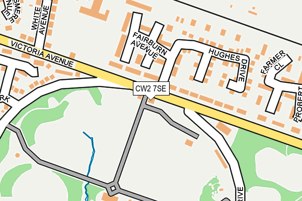
CW2 7SE is located in the Crewe West electoral ward, within the unitary authority of Cheshire East and the English Parliamentary constituency of Crewe and Nantwich. The Sub Integrated Care Board (ICB) Location is NHS Cheshire and Merseyside ICB - 27D and the police force is Cheshire. This postcode has been in use since January 1980.


GetTheData
Source: OS OpenMap – Local (Ordnance Survey)
Source: OS VectorMap District (Ordnance Survey)
Licence: Open Government Licence (requires attribution)
| Easting | 368801 |
| Northing | 355802 |
| Latitude | 53.098516 |
| Longitude | -2.467393 |
GetTheData
Source: Open Postcode Geo
Licence: Open Government Licence
| Country | England |
| Postcode District | CW2 |
➜ See where CW2 is on a map ➜ Where is Crewe? | |
GetTheData
Source: Land Registry Price Paid Data
Licence: Open Government Licence
Elevation or altitude of CW2 7SE as distance above sea level:
| Metres | Feet | |
|---|---|---|
| Elevation | 50m | 164ft |
Elevation is measured from the approximate centre of the postcode, to the nearest point on an OS contour line from OS Terrain 50, which has contour spacing of ten vertical metres.
➜ How high above sea level am I? Find the elevation of your current position using your device's GPS.
GetTheData
Source: Open Postcode Elevation
Licence: Open Government Licence
| Ward | Crewe West |
| Constituency | Crewe And Nantwich |
GetTheData
Source: ONS Postcode Database
Licence: Open Government Licence
| Queens Park Gates (Victoria Avenue) | Crewe | 29m |
| Queens Park Gates (Victoria Avenue) | Crewe | 67m |
| Total Garage (Victoria Avenue) | Crewe | 208m |
| Total Garage (Victoria Avenue) | Crewe | 216m |
| White Avenue (Victoria Avenue) | Crewe | 280m |
| Crewe Station | 2.5km |
| Nantwich Station | 5.2km |
GetTheData
Source: NaPTAN
Licence: Open Government Licence
GetTheData
Source: ONS Postcode Database
Licence: Open Government Licence


➜ Get more ratings from the Food Standards Agency
GetTheData
Source: Food Standards Agency
Licence: FSA terms & conditions
| Last Collection | |||
|---|---|---|---|
| Location | Mon-Fri | Sat | Distance |
| Alton Street West | 17:15 | 12:30 | 455m |
| Marshfield Bank | 17:30 | 12:15 | 615m |
| Aldersey Road | 17:15 | 12:30 | 734m |
GetTheData
Source: Dracos
Licence: Creative Commons Attribution-ShareAlike
The below table lists the International Territorial Level (ITL) codes (formerly Nomenclature of Territorial Units for Statistics (NUTS) codes) and Local Administrative Units (LAU) codes for CW2 7SE:
| ITL 1 Code | Name |
|---|---|
| TLD | North West (England) |
| ITL 2 Code | Name |
| TLD6 | Cheshire |
| ITL 3 Code | Name |
| TLD62 | Cheshire East |
| LAU 1 Code | Name |
| E06000049 | Cheshire East |
GetTheData
Source: ONS Postcode Directory
Licence: Open Government Licence
The below table lists the Census Output Area (OA), Lower Layer Super Output Area (LSOA), and Middle Layer Super Output Area (MSOA) for CW2 7SE:
| Code | Name | |
|---|---|---|
| OA | E00093340 | |
| LSOA | E01018498 | Cheshire East 039E |
| MSOA | E02003830 | Cheshire East 039 |
GetTheData
Source: ONS Postcode Directory
Licence: Open Government Licence
| CW2 7SX | Fairburn Avenue | 82m |
| CW2 7UF | Monarch Close | 113m |
| CW2 7SY | Fairburn Avenue | 152m |
| CW2 7UA | Hughes Drive | 153m |
| CW2 7SN | Queens Park Drive | 211m |
| CW2 7UJ | Morgan Close | 225m |
| CW2 7SQ | Victoria Avenue | 233m |
| CW2 7UD | Farmer Close | 257m |
| CW2 7SH | White Avenue | 258m |
| CW2 7UQ | Coppenhall Grove | 284m |
GetTheData
Source: Open Postcode Geo; Land Registry Price Paid Data
Licence: Open Government Licence