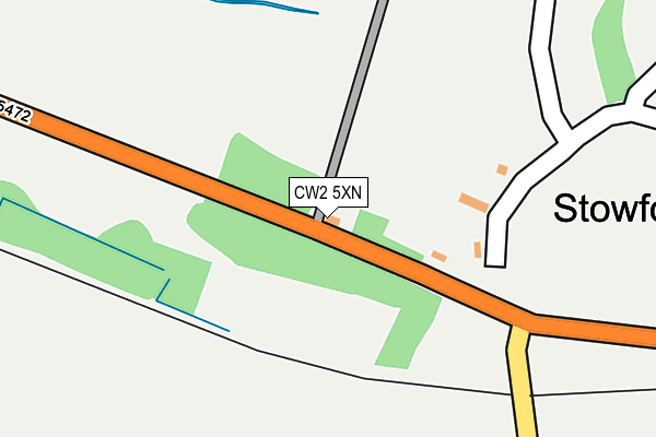
CW2 5XN lies on Weston Road in Crewe. CW2 5XN is located in the Haslington electoral ward, within the unitary authority of Cheshire East and the English Parliamentary constituency of Crewe and Nantwich. The Sub Integrated Care Board (ICB) Location is NHS Cheshire and Merseyside ICB - 27D and the police force is Cheshire. This postcode has been in use since December 1995.


GetTheData
Source: OS OpenMap – Local (Ordnance Survey)
Source: OS VectorMap District (Ordnance Survey)
Licence: Open Government Licence (requires attribution)
| Easting | 373134 |
| Northing | 353378 |
| Latitude | 53.076948 |
| Longitude | -2.402480 |
GetTheData
Source: Open Postcode Geo
Licence: Open Government Licence
| Street | Weston Road |
| Town/City | Crewe |
| Country | England |
| Postcode District | CW2 |
➜ See where CW2 is on a map ➜ Where is Stowford? | |
GetTheData
Source: Land Registry Price Paid Data
Licence: Open Government Licence
Elevation or altitude of CW2 5XN as distance above sea level:
| Metres | Feet | |
|---|---|---|
| Elevation | 60m | 197ft |
Elevation is measured from the approximate centre of the postcode, to the nearest point on an OS contour line from OS Terrain 50, which has contour spacing of ten vertical metres.
➜ How high above sea level am I? Find the elevation of your current position using your device's GPS.
GetTheData
Source: Open Postcode Elevation
Licence: Open Government Licence
| Ward | Haslington |
| Constituency | Crewe And Nantwich |
GetTheData
Source: ONS Postcode Database
Licence: Open Government Licence
| Crewe Hall Entrance (Weston Road) | Stowford | 30m |
| Crewe Hall Entrance (Weston Road) | Stowford | 78m |
| Carters Green Farm (Main Road) | Weston | 477m |
| Carters Green Farm (Main Road) | Weston | 483m |
| Stepping Stones Nursery (Main Road) | Weston | 937m |
| Crewe Station | 2.5km |
GetTheData
Source: NaPTAN
Licence: Open Government Licence
GetTheData
Source: ONS Postcode Database
Licence: Open Government Licence


➜ Get more ratings from the Food Standards Agency
GetTheData
Source: Food Standards Agency
Licence: FSA terms & conditions
| Last Collection | |||
|---|---|---|---|
| Location | Mon-Fri | Sat | Distance |
| Weston So | 17:30 | 10:15 | 1,145m |
| Crewe Gates Ind Estate | 18:30 | 1,591m | |
| Crewe Gates Ind Estate | 18:30 | 11:00 | 1,596m |
GetTheData
Source: Dracos
Licence: Creative Commons Attribution-ShareAlike
The below table lists the International Territorial Level (ITL) codes (formerly Nomenclature of Territorial Units for Statistics (NUTS) codes) and Local Administrative Units (LAU) codes for CW2 5XN:
| ITL 1 Code | Name |
|---|---|
| TLD | North West (England) |
| ITL 2 Code | Name |
| TLD6 | Cheshire |
| ITL 3 Code | Name |
| TLD62 | Cheshire East |
| LAU 1 Code | Name |
| E06000049 | Cheshire East |
GetTheData
Source: ONS Postcode Directory
Licence: Open Government Licence
The below table lists the Census Output Area (OA), Lower Layer Super Output Area (LSOA), and Middle Layer Super Output Area (MSOA) for CW2 5XN:
| Code | Name | |
|---|---|---|
| OA | E00093181 | |
| LSOA | E01018465 | Cheshire East 041A |
| MSOA | E02003831 | Cheshire East 041 |
GetTheData
Source: ONS Postcode Directory
Licence: Open Government Licence
| CW2 5NN | Whites Lane | 827m |
| CW2 5QR | Fourways | 1080m |
| CW2 5LG | Smithy Lane | 1089m |
| CW2 5LJ | Cemetery Road | 1101m |
| CW2 5LL | Ferndale Close | 1110m |
| CW2 5LF | Main Road | 1111m |
| CW2 5LH | Cemetery Road | 1132m |
| CW2 5GL | Mere Court | 1134m |
| CW2 5LQ | Cemetery Road | 1134m |
| CW2 5LT | Westmere Close | 1168m |
GetTheData
Source: Open Postcode Geo; Land Registry Price Paid Data
Licence: Open Government Licence