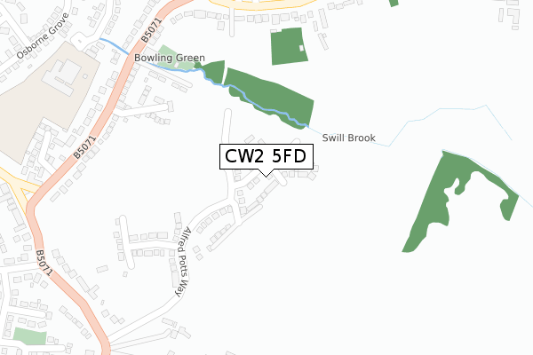
CW2 5FD is located in the Shavington electoral ward, within the unitary authority of Cheshire East and the English Parliamentary constituency of Crewe and Nantwich. The Sub Integrated Care Board (ICB) Location is NHS Cheshire and Merseyside ICB - 27D and the police force is Cheshire. This postcode has been in use since December 2019.


GetTheData
Source: OS Open Zoomstack (Ordnance Survey)
Licence: Open Government Licence (requires attribution)
Attribution: Contains OS data © Crown copyright and database right 2025
Source: Open Postcode Geo
Licence: Open Government Licence (requires attribution)
Attribution: Contains OS data © Crown copyright and database right 2025; Contains Royal Mail data © Royal Mail copyright and database right 2025; Source: Office for National Statistics licensed under the Open Government Licence v.3.0
| Easting | 370596 |
| Northing | 351810 |
| Latitude | 53.062736 |
| Longitude | -2.440220 |
GetTheData
Source: Open Postcode Geo
Licence: Open Government Licence
| Country | England |
| Postcode District | CW2 |
➜ See where CW2 is on a map ➜ Where is Shavington? | |
GetTheData
Source: Land Registry Price Paid Data
Licence: Open Government Licence
| Ward | Shavington |
| Constituency | Crewe And Nantwich |
GetTheData
Source: ONS Postcode Database
Licence: Open Government Licence
8, WILLIAM STOCKTON CLOSE, SHAVINGTON, CREWE, CW2 5FD 2020 4 SEP £274,995 |
7, WILLIAM STOCKTON CLOSE, SHAVINGTON, CREWE, CW2 5FD 2020 21 AUG £372,995 |
9, WILLIAM STOCKTON CLOSE, SHAVINGTON, CREWE, CW2 5FD 2020 21 AUG £354,995 |
5, WILLIAM STOCKTON CLOSE, SHAVINGTON, CREWE, CW2 5FD 2020 6 AUG £274,995 |
3, WILLIAM STOCKTON CLOSE, SHAVINGTON, CREWE, CW2 5FD 2020 27 MAR £315,995 |
10, WILLIAM STOCKTON CLOSE, SHAVINGTON, CREWE, CW2 5FD 2020 30 JAN £295,995 |
6, WILLIAM STOCKTON CLOSE, SHAVINGTON, CREWE, CW2 5FD 2019 20 DEC £349,995 |
4, WILLIAM STOCKTON CLOSE, SHAVINGTON, CREWE, CW2 5FD 2019 12 DEC £193,596 |
GetTheData
Source: HM Land Registry Price Paid Data
Licence: Contains HM Land Registry data © Crown copyright and database right 2025. This data is licensed under the Open Government Licence v3.0.
| Park Estate (Weston Lane) | Shavington | 322m |
| Park Estate (Weston Lane) | Shavington | 335m |
| Brook Avenue (Crewe Road) | Shavington | 363m |
| Brook Avenue (Crewe Road) | Shavington | 369m |
| Sugar Loaf (Crewe Road) | Shavington | 456m |
| Crewe Station | 3km |
GetTheData
Source: NaPTAN
Licence: Open Government Licence
GetTheData
Source: ONS Postcode Database
Licence: Open Government Licence


➜ Get more ratings from the Food Standards Agency
GetTheData
Source: Food Standards Agency
Licence: FSA terms & conditions
| Last Collection | |||
|---|---|---|---|
| Location | Mon-Fri | Sat | Distance |
| Shavington So | 17:30 | 11:30 | 698m |
| Hollymount | 17:15 | 10:15 | 738m |
| Hough So | 17:30 | 09:00 | 1,000m |
GetTheData
Source: Dracos
Licence: Creative Commons Attribution-ShareAlike
The below table lists the International Territorial Level (ITL) codes (formerly Nomenclature of Territorial Units for Statistics (NUTS) codes) and Local Administrative Units (LAU) codes for CW2 5FD:
| ITL 1 Code | Name |
|---|---|
| TLD | North West (England) |
| ITL 2 Code | Name |
| TLD6 | Cheshire |
| ITL 3 Code | Name |
| TLD62 | Cheshire East |
| LAU 1 Code | Name |
| E06000049 | Cheshire East |
GetTheData
Source: ONS Postcode Directory
Licence: Open Government Licence
The below table lists the Census Output Area (OA), Lower Layer Super Output Area (LSOA), and Middle Layer Super Output Area (MSOA) for CW2 5FD:
| Code | Name | |
|---|---|---|
| OA | E00093326 | |
| LSOA | E01018494 | Cheshire East 048B |
| MSOA | E02003838 | Cheshire East 048 |
GetTheData
Source: ONS Postcode Directory
Licence: Open Government Licence
| CW2 5HZ | The Orchards | 280m |
| CW2 5DN | Brook Avenue | 288m |
| CW2 5AN | Weston Lane | 354m |
| CW2 5DL | Crewe Road | 361m |
| CW2 5BD | Richardson Close | 367m |
| CW2 5DW | Crewe Road | 368m |
| CW2 5JB | Crewe Road | 420m |
| CW2 5BP | South Bank Avenue | 430m |
| CW2 5BE | Meadow Close | 453m |
| CW2 5DQ | Lime Grove | 461m |
GetTheData
Source: Open Postcode Geo; Land Registry Price Paid Data
Licence: Open Government Licence