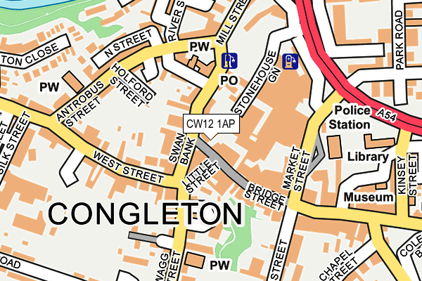
CW12 1AP lies on Duke Street in Congleton. CW12 1AP is located in the Congleton West electoral ward, within the unitary authority of Cheshire East and the English Parliamentary constituency of Congleton. The Sub Integrated Care Board (ICB) Location is NHS Cheshire and Merseyside ICB - 27D and the police force is Cheshire. This postcode has been in use since January 1980.


GetTheData
Source: OS OpenMap – Local (Ordnance Survey)
Source: OS VectorMap District (Ordnance Survey)
Licence: Open Government Licence (requires attribution)
| Easting | 385782 |
| Northing | 362983 |
| Latitude | 53.163776 |
| Longitude | -2.214115 |
GetTheData
Source: Open Postcode Geo
Licence: Open Government Licence
| Street | Duke Street |
| Town/City | Congleton |
| Country | England |
| Postcode District | CW12 |
➜ See where CW12 is on a map ➜ Where is Congleton? | |
GetTheData
Source: Land Registry Price Paid Data
Licence: Open Government Licence
Elevation or altitude of CW12 1AP as distance above sea level:
| Metres | Feet | |
|---|---|---|
| Elevation | 90m | 295ft |
Elevation is measured from the approximate centre of the postcode, to the nearest point on an OS contour line from OS Terrain 50, which has contour spacing of ten vertical metres.
➜ How high above sea level am I? Find the elevation of your current position using your device's GPS.
GetTheData
Source: Open Postcode Elevation
Licence: Open Government Licence
| Ward | Congleton West |
| Constituency | Congleton |
GetTheData
Source: ONS Postcode Database
Licence: Open Government Licence
4, DUKE STREET, CONGLETON, CW12 1AP 2007 11 MAY £310,000 |
GetTheData
Source: HM Land Registry Price Paid Data
Licence: Contains HM Land Registry data © Crown copyright and database right 2025. This data is licensed under the Open Government Licence v3.0.
| Antrobus Street (Mill Street) | Congleton | 110m |
| West Street | Congleton | 137m |
| Market Street Alighting Only (High Street) | Congleton | 175m |
| Antrobus Street (Mill Street) | Congleton | 187m |
| West Street (Antrobus Street) | Congleton | 196m |
| Congleton Station | 1.6km |
GetTheData
Source: NaPTAN
Licence: Open Government Licence
GetTheData
Source: ONS Postcode Database
Licence: Open Government Licence


➜ Get more ratings from the Food Standards Agency
GetTheData
Source: Food Standards Agency
Licence: FSA terms & conditions
| Last Collection | |||
|---|---|---|---|
| Location | Mon-Fri | Sat | Distance |
| Mill Street | 18:00 | 12:30 | 22m |
| West End Cottage | 17:30 | 11:45 | 109m |
| Swan Street | 17:30 | 11:00 | 261m |
GetTheData
Source: Dracos
Licence: Creative Commons Attribution-ShareAlike
| Risk of CW12 1AP flooding from rivers and sea | Medium |
| ➜ CW12 1AP flood map | |
GetTheData
Source: Open Flood Risk by Postcode
Licence: Open Government Licence
The below table lists the International Territorial Level (ITL) codes (formerly Nomenclature of Territorial Units for Statistics (NUTS) codes) and Local Administrative Units (LAU) codes for CW12 1AP:
| ITL 1 Code | Name |
|---|---|
| TLD | North West (England) |
| ITL 2 Code | Name |
| TLD6 | Cheshire |
| ITL 3 Code | Name |
| TLD62 | Cheshire East |
| LAU 1 Code | Name |
| E06000049 | Cheshire East |
GetTheData
Source: ONS Postcode Directory
Licence: Open Government Licence
The below table lists the Census Output Area (OA), Lower Layer Super Output Area (LSOA), and Middle Layer Super Output Area (MSOA) for CW12 1AP:
| Code | Name | |
|---|---|---|
| OA | E00092855 | |
| LSOA | E01018402 | Cheshire East 027C |
| MSOA | E02003816 | Cheshire East 027 |
GetTheData
Source: ONS Postcode Directory
Licence: Open Government Licence
| CW12 1AS | Bridge Street | 38m |
| CW12 1AN | Swan Bank | 44m |
| CW12 1AB | Mill Street | 49m |
| CW12 1AR | Little Street | 56m |
| CW12 1AH | Swan Bank | 62m |
| CW12 1AY | Bridge Street | 81m |
| CW12 1AU | High Street | 101m |
| CW12 1HA | Holford Street | 123m |
| CW12 1HH | South Street | 124m |
| CW12 1BA | High Street | 126m |
GetTheData
Source: Open Postcode Geo; Land Registry Price Paid Data
Licence: Open Government Licence