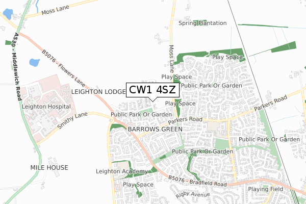
CW1 4SZ is located in the Leighton electoral ward, within the unitary authority of Cheshire East and the English Parliamentary constituency of Eddisbury. The Sub Integrated Care Board (ICB) Location is NHS Cheshire and Merseyside ICB - 27D and the police force is Cheshire. This postcode has been in use since March 2019.


GetTheData
Source: OS Open Zoomstack (Ordnance Survey)
Licence: Open Government Licence (requires attribution)
Attribution: Contains OS data © Crown copyright and database right 2025
Source: Open Postcode Geo
Licence: Open Government Licence (requires attribution)
Attribution: Contains OS data © Crown copyright and database right 2025; Contains Royal Mail data © Royal Mail copyright and database right 2025; Source: Office for National Statistics licensed under the Open Government Licence v.3.0
| Easting | 369127 |
| Northing | 358093 |
| Latitude | 53.119128 |
| Longitude | -2.462745 |
GetTheData
Source: Open Postcode Geo
Licence: Open Government Licence
| Country | England |
| Postcode District | CW1 |
➜ See where CW1 is on a map ➜ Where is Crewe? | |
GetTheData
Source: Land Registry Price Paid Data
Licence: Open Government Licence
| Ward | Leighton |
| Constituency | Eddisbury |
GetTheData
Source: ONS Postcode Database
Licence: Open Government Licence
2, ORCHARDFIELD CLOSE, CREWE, CW1 4SZ 2022 8 JUN £264,995 |
16, ORCHARDFIELD CLOSE, CREWE, CW1 4SZ 2021 13 SEP £224,400 |
14, ORCHARDFIELD CLOSE, CREWE, CW1 4SZ 2021 3 SEP £264,995 |
12, ORCHARDFIELD CLOSE, CREWE, CW1 4SZ 2021 27 AUG £262,500 |
3, ORCHARDFIELD CLOSE, CREWE, CW1 4SZ 2021 26 JUL £292,995 |
9, ORCHARDFIELD CLOSE, CREWE, CW1 4SZ 2021 23 JUL £292,995 |
1, ORCHARDFIELD CLOSE, CREWE, CW1 4SZ 2019 12 MAR £254,995 |
GetTheData
Source: HM Land Registry Price Paid Data
Licence: Contains HM Land Registry data © Crown copyright and database right 2025. This data is licensed under the Open Government Licence v3.0.
| Becconsall Drive (Parkers Road) | Coppenhall | 207m |
| Becconsall Drive (Parkers Road) | Coppenhall | 238m |
| Parkfield (Parkers Road) | Coppenhall | 325m |
| Parkers Road (Bradfield Road) | Coppenhall | 328m |
| Parkers Road (Bradfield Road) | Coppenhall | 345m |
| Crewe Station | 3.8km |
| Sandbach Station | 5.8km |
GetTheData
Source: NaPTAN
Licence: Open Government Licence
GetTheData
Source: ONS Postcode Database
Licence: Open Government Licence


➜ Get more ratings from the Food Standards Agency
GetTheData
Source: Food Standards Agency
Licence: FSA terms & conditions
| Last Collection | |||
|---|---|---|---|
| Location | Mon-Fri | Sat | Distance |
| Tollemache Drive | 17:10 | 11:30 | 360m |
| Leighton Hospital | 16:00 | 11:15 | 879m |
| Ford Lane | 17:30 | 12:00 | 2,198m |
GetTheData
Source: Dracos
Licence: Creative Commons Attribution-ShareAlike
The below table lists the International Territorial Level (ITL) codes (formerly Nomenclature of Territorial Units for Statistics (NUTS) codes) and Local Administrative Units (LAU) codes for CW1 4SZ:
| ITL 1 Code | Name |
|---|---|
| TLD | North West (England) |
| ITL 2 Code | Name |
| TLD6 | Cheshire |
| ITL 3 Code | Name |
| TLD62 | Cheshire East |
| LAU 1 Code | Name |
| E06000049 | Cheshire East |
GetTheData
Source: ONS Postcode Directory
Licence: Open Government Licence
The below table lists the Census Output Area (OA), Lower Layer Super Output Area (LSOA), and Middle Layer Super Output Area (MSOA) for CW1 4SZ:
| Code | Name | |
|---|---|---|
| OA | E00093258 | |
| LSOA | E01018480 | Cheshire East 049B |
| MSOA | E02003837 | Cheshire East 049 |
GetTheData
Source: ONS Postcode Directory
Licence: Open Government Licence
| CW1 4FT | Higher Croft Drive | 51m |
| CW1 4GY | Great Tithes Place | 93m |
| CW1 4GZ | Picking Drive | 102m |
| CW1 4FW | Wades Field Place | 117m |
| CW1 4GX | House Yard Close | 142m |
| CW1 4FX | Barn Field Close | 154m |
| CW1 4GA | Parkers Road | 192m |
| CW1 4UA | Thorn Tree Drive | 223m |
| CW1 4RX | Becconsall Close | 235m |
| CW1 4TT | Parkfield | 269m |
GetTheData
Source: Open Postcode Geo; Land Registry Price Paid Data
Licence: Open Government Licence