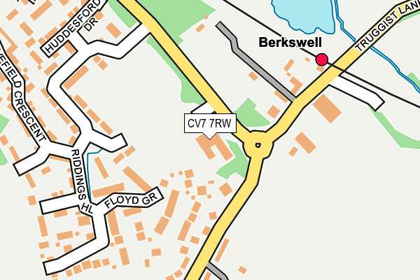
CV7 7RW is located in the Meriden electoral ward, within the metropolitan district of Solihull and the English Parliamentary constituency of Meriden. The Sub Integrated Care Board (ICB) Location is NHS Birmingham and Solihull ICB - 15E and the police force is West Midlands. This postcode has been in use since February 2012.


GetTheData
Source: OS OpenMap – Local (Ordnance Survey)
Source: OS VectorMap District (Ordnance Survey)
Licence: Open Government Licence (requires attribution)
| Easting | 424331 |
| Northing | 277497 |
| Latitude | 52.394956 |
| Longitude | -1.643862 |
GetTheData
Source: Open Postcode Geo
Licence: Open Government Licence
| Country | England |
| Postcode District | CV7 |
➜ See where CV7 is on a map ➜ Where is Balsall Common? | |
GetTheData
Source: Land Registry Price Paid Data
Licence: Open Government Licence
Elevation or altitude of CV7 7RW as distance above sea level:
| Metres | Feet | |
|---|---|---|
| Elevation | 110m | 361ft |
Elevation is measured from the approximate centre of the postcode, to the nearest point on an OS contour line from OS Terrain 50, which has contour spacing of ten vertical metres.
➜ How high above sea level am I? Find the elevation of your current position using your device's GPS.
GetTheData
Source: Open Postcode Elevation
Licence: Open Government Licence
| Ward | Meriden |
| Constituency | Meriden |
GetTheData
Source: ONS Postcode Database
Licence: Open Government Licence
| Truggist Lane (Station Rd) | Balsall Common | 91m |
| Balsall Common Main Island (Kenilworth Rd) | Balsall Common | 541m |
| Balsall Common Main Island (Kenilworth Rd) | Balsall Common | 559m |
| Elmwood Close (Kenilworth Rd) | Balsall Common | 590m |
| Balsall Common Island (Station Rd) | Balsall Common | 601m |
| Berkswell Station | 0.1km |
| Tile Hill Station | 3.2km |
| Hampton-in-Arden Station | 5.4km |
GetTheData
Source: NaPTAN
Licence: Open Government Licence
GetTheData
Source: ONS Postcode Database
Licence: Open Government Licence


➜ Get more ratings from the Food Standards Agency
GetTheData
Source: Food Standards Agency
Licence: FSA terms & conditions
| Last Collection | |||
|---|---|---|---|
| Location | Mon-Fri | Sat | Distance |
| Balsall Common Post Office | 18:30 | 10:45 | 499m |
| Balsall Common Post Office | 18:30 | 10:45 | 500m |
| High Cross | 16:30 | 10:30 | 1,228m |
GetTheData
Source: Dracos
Licence: Creative Commons Attribution-ShareAlike
The below table lists the International Territorial Level (ITL) codes (formerly Nomenclature of Territorial Units for Statistics (NUTS) codes) and Local Administrative Units (LAU) codes for CV7 7RW:
| ITL 1 Code | Name |
|---|---|
| TLG | West Midlands (England) |
| ITL 2 Code | Name |
| TLG3 | West Midlands |
| ITL 3 Code | Name |
| TLG32 | Solihull |
| LAU 1 Code | Name |
| E08000029 | Solihull |
GetTheData
Source: ONS Postcode Directory
Licence: Open Government Licence
The below table lists the Census Output Area (OA), Lower Layer Super Output Area (LSOA), and Middle Layer Super Output Area (MSOA) for CV7 7RW:
| Code | Name | |
|---|---|---|
| OA | E00051407 | |
| LSOA | E01010169 | Solihull 025C |
| MSOA | E02002105 | Solihull 025 |
GetTheData
Source: ONS Postcode Directory
Licence: Open Government Licence
| CV7 7EN | Brickyard Close | 112m |
| CV7 7RP | Floyd Grove | 114m |
| CV7 7EF | Station Road | 118m |
| CV7 7RN | Watson Way | 138m |
| CV7 7RA | Riddings Hill | 207m |
| CV7 7RR | Huddesford Drive | 249m |
| CV7 7RX | Huggins Close | 267m |
| CV7 7RT | Meadow Rise | 278m |
| CV7 7EE | Station Road | 293m |
| CV7 7EG | Station Road | 296m |
GetTheData
Source: Open Postcode Geo; Land Registry Price Paid Data
Licence: Open Government Licence