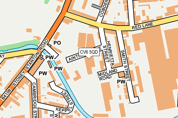
CV6 5QD is located in the Foleshill electoral ward, within the metropolitan district of Coventry and the English Parliamentary constituency of Coventry North East. The Sub Integrated Care Board (ICB) Location is NHS Coventry and Warwickshire ICB - B2M3M and the police force is West Midlands. This postcode has been in use since December 1998.


GetTheData
Source: OS OpenMap – Local (Ordnance Survey)
Source: OS VectorMap District (Ordnance Survey)
Licence: Open Government Licence (requires attribution)
| Easting | 434407 |
| Northing | 280269 |
| Latitude | 52.419337 |
| Longitude | -1.495508 |
GetTheData
Source: Open Postcode Geo
Licence: Open Government Licence
| Country | England |
| Postcode District | CV6 |
➜ See where CV6 is on a map ➜ Where is Coventry? | |
GetTheData
Source: Land Registry Price Paid Data
Licence: Open Government Licence
Elevation or altitude of CV6 5QD as distance above sea level:
| Metres | Feet | |
|---|---|---|
| Elevation | 90m | 295ft |
Elevation is measured from the approximate centre of the postcode, to the nearest point on an OS contour line from OS Terrain 50, which has contour spacing of ten vertical metres.
➜ How high above sea level am I? Find the elevation of your current position using your device's GPS.
GetTheData
Source: Open Postcode Elevation
Licence: Open Government Licence
| Ward | Foleshill |
| Constituency | Coventry North East |
GetTheData
Source: ONS Postcode Database
Licence: Open Government Licence
| Red Lane (Stoney Stanton Rd) | Bishopgate Green | 153m |
| Red Lane (Stoney Stanton Rd) | Bishopgate Green | 211m |
| Cambridge St (Stoney Stanton Rd) | Bishopgate Green | 242m |
| Cambridge St (Stoney Stanton Rd) | Bishopgate Green | 257m |
| Peel St (Stoney Stanton Rd) | Stoke Heath | 295m |
| Coventry Station | 2.4km |
| Coventry Arena Station | 3.2km |
| Canley Station | 4.2km |
GetTheData
Source: NaPTAN
Licence: Open Government Licence
GetTheData
Source: ONS Postcode Database
Licence: Open Government Licence


➜ Get more ratings from the Food Standards Agency
GetTheData
Source: Food Standards Agency
Licence: FSA terms & conditions
| Last Collection | |||
|---|---|---|---|
| Location | Mon-Fri | Sat | Distance |
| Smith Street | 17:45 | 12:00 | 123m |
| Harnall Lane East | 17:30 | 09:45 | 416m |
| Vauxhall | 18:00 | 10:15 | 463m |
GetTheData
Source: Dracos
Licence: Creative Commons Attribution-ShareAlike
The below table lists the International Territorial Level (ITL) codes (formerly Nomenclature of Territorial Units for Statistics (NUTS) codes) and Local Administrative Units (LAU) codes for CV6 5QD:
| ITL 1 Code | Name |
|---|---|
| TLG | West Midlands (England) |
| ITL 2 Code | Name |
| TLG3 | West Midlands |
| ITL 3 Code | Name |
| TLG33 | Coventry |
| LAU 1 Code | Name |
| E08000026 | Coventry |
GetTheData
Source: ONS Postcode Directory
Licence: Open Government Licence
The below table lists the Census Output Area (OA), Lower Layer Super Output Area (LSOA), and Middle Layer Super Output Area (MSOA) for CV6 5QD:
| Code | Name | |
|---|---|---|
| OA | E00048460 | |
| LSOA | E01009572 | Coventry 015D |
| MSOA | E02001972 | Coventry 015 |
GetTheData
Source: ONS Postcode Directory
Licence: Open Government Licence
| CV6 5EF | Henrietta Street | 74m |
| CV6 5EG | Edward Street | 75m |
| CV6 5EE | Red Lane | 108m |
| CV6 5DR | Ordnance Road | 118m |
| CV6 5EH | Smith Street | 130m |
| CV6 5DS | Stoney Stanton Road | 137m |
| CV6 5EP | Red Lane | 137m |
| CV6 5EL | Smith Street | 145m |
| CV1 5HP | Keppel Street | 165m |
| CV1 5HS | Cambridge Street | 200m |
GetTheData
Source: Open Postcode Geo; Land Registry Price Paid Data
Licence: Open Government Licence