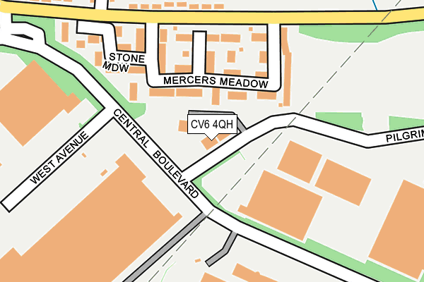
CV6 4QH lies on Pilgrims Walk in Prologis Park, Coventry. CV6 4QH is located in the Exhall electoral ward, within the local authority district of Nuneaton and Bedworth and the English Parliamentary constituency of North Warwickshire. The Sub Integrated Care Board (ICB) Location is NHS Coventry and Warwickshire ICB - B2M3M and the police force is Warwickshire. This postcode has been in use since August 2006.


GetTheData
Source: OS OpenMap – Local (Ordnance Survey)
Source: OS VectorMap District (Ordnance Survey)
Licence: Open Government Licence (requires attribution)
| Easting | 432425 |
| Northing | 284499 |
| Latitude | 52.457485 |
| Longitude | -1.524241 |
GetTheData
Source: Open Postcode Geo
Licence: Open Government Licence
| Street | Pilgrims Walk |
| Locality | Prologis Park |
| Town/City | Coventry |
| Country | England |
| Postcode District | CV6 |
➜ See where CV6 is on a map ➜ Where is Keresley Newlands? | |
GetTheData
Source: Land Registry Price Paid Data
Licence: Open Government Licence
Elevation or altitude of CV6 4QH as distance above sea level:
| Metres | Feet | |
|---|---|---|
| Elevation | 130m | 427ft |
Elevation is measured from the approximate centre of the postcode, to the nearest point on an OS contour line from OS Terrain 50, which has contour spacing of ten vertical metres.
➜ How high above sea level am I? Find the elevation of your current position using your device's GPS.
GetTheData
Source: Open Postcode Elevation
Licence: Open Government Licence
| Ward | Exhall |
| Constituency | North Warwickshire |
GetTheData
Source: ONS Postcode Database
Licence: Open Government Licence
| Terex (Central Boulevard) | Keresley | 73m |
| Terex (Central Boulevard) | Keresley | 82m |
| Morrisons (Central Boulevard) | Keresley | 159m |
| Mercers Meadow (Exhall Road) | Keresley | 167m |
| Morrisons (Central Boulevard) | Keresley | 172m |
| Coventry Arena Station | 2.3km |
| Bedworth Station | 4.6km |
| Bermuda Park Station | 6km |
GetTheData
Source: NaPTAN
Licence: Open Government Licence
GetTheData
Source: ONS Postcode Database
Licence: Open Government Licence


➜ Get more ratings from the Food Standards Agency
GetTheData
Source: Food Standards Agency
Licence: FSA terms & conditions
| Last Collection | |||
|---|---|---|---|
| Location | Mon-Fri | Sat | Distance |
| Keresley End Post Office | 16:30 | 11:30 | 629m |
| Fivefield Road | 16:00 | 11:45 | 900m |
| Ash Green Post Office | 18:45 | 10:30 | 1,109m |
GetTheData
Source: Dracos
Licence: Creative Commons Attribution-ShareAlike
The below table lists the International Territorial Level (ITL) codes (formerly Nomenclature of Territorial Units for Statistics (NUTS) codes) and Local Administrative Units (LAU) codes for CV6 4QH:
| ITL 1 Code | Name |
|---|---|
| TLG | West Midlands (England) |
| ITL 2 Code | Name |
| TLG1 | Herefordshire, Worcestershire and Warwickshire |
| ITL 3 Code | Name |
| TLG13 | Warwickshire CC |
| LAU 1 Code | Name |
| E07000219 | Nuneaton and Bedworth |
GetTheData
Source: ONS Postcode Directory
Licence: Open Government Licence
The below table lists the Census Output Area (OA), Lower Layer Super Output Area (LSOA), and Middle Layer Super Output Area (MSOA) for CV6 4QH:
| Code | Name | |
|---|---|---|
| OA | E00158437 | |
| LSOA | E01031078 | Nuneaton and Bedworth 018B |
| MSOA | E02006806 | Nuneaton and Bedworth 018 |
GetTheData
Source: ONS Postcode Directory
Licence: Open Government Licence
| CV7 8RF | Mercers Meadow | 98m |
| CV7 8RE | Garlands Croft | 125m |
| CV7 8LP | Exhall Road | 202m |
| CV7 8RB | Stone Meadow | 207m |
| CV7 8LY | Synkere Close | 263m |
| CV6 4QE | West Avenue | 264m |
| CV7 8LW | Shaftesbury Avenue | 309m |
| CV7 8LX | Shaftesbury Avenue | 352m |
| CV7 8LR | Parkfield Road | 362m |
| CV7 8LN | Exhall Road | 371m |
GetTheData
Source: Open Postcode Geo; Land Registry Price Paid Data
Licence: Open Government Licence