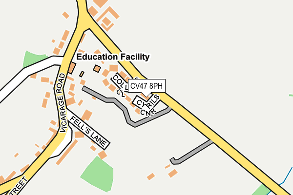
CV47 8PH is located in the Bishop's Itchington, Fenny Compton & Napton electoral ward, within the local authority district of Stratford-on-Avon and the English Parliamentary constituency of Kenilworth and Southam. The Sub Integrated Care Board (ICB) Location is NHS Coventry and Warwickshire ICB - B2M3M and the police force is Warwickshire. This postcode has been in use since March 2017.


GetTheData
Source: OS OpenMap – Local (Ordnance Survey)
Source: OS VectorMap District (Ordnance Survey)
Licence: Open Government Licence (requires attribution)
| Easting | 446801 |
| Northing | 261412 |
| Latitude | 52.248919 |
| Longitude | -1.315886 |
GetTheData
Source: Open Postcode Geo
Licence: Open Government Licence
| Country | England |
| Postcode District | CV47 |
➜ See where CV47 is on a map | |
GetTheData
Source: Land Registry Price Paid Data
Licence: Open Government Licence
| Ward | Bishop's Itchington, Fenny Compton & Napton |
| Constituency | Kenilworth And Southam |
GetTheData
Source: ONS Postcode Database
Licence: Open Government Licence
| Kings Head (Butt Hill) | Napton On The Hill | 529m |
| Crown (High Street) | Napton On The Hill | 537m |
| Crown (High Street) | Napton On The Hill | 552m |
| Kings Head (Butt Hill) | Napton On The Hill | 575m |
GetTheData
Source: NaPTAN
Licence: Open Government Licence
| Percentage of properties with Next Generation Access | 100.0% |
| Percentage of properties with Superfast Broadband | 100.0% |
| Percentage of properties with Ultrafast Broadband | 0.0% |
| Percentage of properties with Full Fibre Broadband | 0.0% |
Superfast Broadband is between 30Mbps and 300Mbps
Ultrafast Broadband is > 300Mbps
| Median download speed | 36.1Mbps |
| Average download speed | 33.9Mbps |
| Maximum download speed | 55.00Mbps |
| Median upload speed | 9.4Mbps |
| Average upload speed | 7.9Mbps |
| Maximum upload speed | 11.16Mbps |
| Percentage of properties unable to receive 2Mbps | 0.0% |
| Percentage of properties unable to receive 5Mbps | 0.0% |
| Percentage of properties unable to receive 10Mbps | 0.0% |
| Percentage of properties unable to receive 30Mbps | 0.0% |
GetTheData
Source: Ofcom
Licence: Ofcom Terms of Use (requires attribution)
GetTheData
Source: ONS Postcode Database
Licence: Open Government Licence


➜ Get more ratings from the Food Standards Agency
GetTheData
Source: Food Standards Agency
Licence: FSA terms & conditions
| Last Collection | |||
|---|---|---|---|
| Location | Mon-Fri | Sat | Distance |
| Butt Hill | 16:00 | 10:45 | 244m |
| Priors Marston Post Office | 15:30 | 07:30 | 4,207m |
| Main Street | 15:30 | 07:30 | 4,715m |
GetTheData
Source: Dracos
Licence: Creative Commons Attribution-ShareAlike
The below table lists the International Territorial Level (ITL) codes (formerly Nomenclature of Territorial Units for Statistics (NUTS) codes) and Local Administrative Units (LAU) codes for CV47 8PH:
| ITL 1 Code | Name |
|---|---|
| TLG | West Midlands (England) |
| ITL 2 Code | Name |
| TLG1 | Herefordshire, Worcestershire and Warwickshire |
| ITL 3 Code | Name |
| TLG13 | Warwickshire CC |
| LAU 1 Code | Name |
| E07000221 | Stratford-on-Avon |
GetTheData
Source: ONS Postcode Directory
Licence: Open Government Licence
The below table lists the Census Output Area (OA), Lower Layer Super Output Area (LSOA), and Middle Layer Super Output Area (MSOA) for CV47 8PH:
| Code | Name | |
|---|---|---|
| OA | E00159186 | |
| LSOA | E01031224 | Stratford-on-Avon 004F |
| MSOA | E02006507 | Stratford-on-Avon 004 |
GetTheData
Source: ONS Postcode Directory
Licence: Open Government Licence
| CV47 8PJ | Collins Close | 61m |
| CV47 8ND | Fells Lane | 152m |
| CV47 8FJ | Vicarage Place | 184m |
| CV47 8NA | Vicarage Road | 195m |
| CV47 8NE | Butt Hill | 310m |
| CV47 8FH | Hackwell Bank | 318m |
| CV47 8LX | Godsons Lane | 397m |
| CV47 8LU | St Lawrence Close | 407m |
| CV47 8LY | Hackwell Street | 412m |
| CV47 8NN | School Hill | 434m |
GetTheData
Source: Open Postcode Geo; Land Registry Price Paid Data
Licence: Open Government Licence