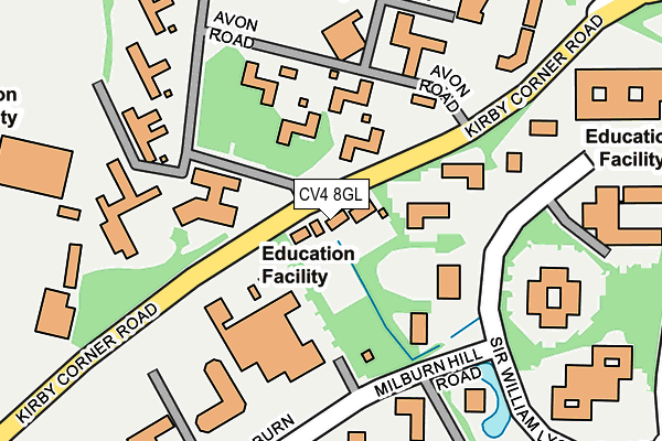
CV4 8GL lies on Kirby Corner Road in Coventry. CV4 8GL is located in the Wainbody electoral ward, within the metropolitan district of Coventry and the English Parliamentary constituency of Coventry South. The Sub Integrated Care Board (ICB) Location is NHS Coventry and Warwickshire ICB - B2M3M and the police force is West Midlands. This postcode has been in use since January 1980.


GetTheData
Source: OS OpenMap – Local (Ordnance Survey)
Source: OS VectorMap District (Ordnance Survey)
Licence: Open Government Licence (requires attribution)
| Easting | 429973 |
| Northing | 276729 |
| Latitude | 52.387774 |
| Longitude | -1.561019 |
GetTheData
Source: Open Postcode Geo
Licence: Open Government Licence
| Street | Kirby Corner Road |
| Town/City | Coventry |
| Country | England |
| Postcode District | CV4 |
➜ See where CV4 is on a map ➜ Where is Coventry? | |
GetTheData
Source: Land Registry Price Paid Data
Licence: Open Government Licence
Elevation or altitude of CV4 8GL as distance above sea level:
| Metres | Feet | |
|---|---|---|
| Elevation | 90m | 295ft |
Elevation is measured from the approximate centre of the postcode, to the nearest point on an OS contour line from OS Terrain 50, which has contour spacing of ten vertical metres.
➜ How high above sea level am I? Find the elevation of your current position using your device's GPS.
GetTheData
Source: Open Postcode Elevation
Licence: Open Government Licence
| Ward | Wainbody |
| Constituency | Coventry South |
GetTheData
Source: ONS Postcode Database
Licence: Open Government Licence
WOODSTOCK, KIRBY CORNER ROAD, COVENTRY, CV4 8GL 2016 31 MAR £515,000 |
FORTH HOUSE, KIRBY CORNER ROAD, COVENTRY, CV4 8GL 2000 9 FEB £100,000 |
MARINA, KIRBY CORNER ROAD, COVENTRY, CV4 8GL 1998 17 AUG £106,500 |
FORTH HOUSE, KIRBY CORNER ROAD, COVENTRY, CV4 8GL 1998 31 MAR £56,000 |
GetTheData
Source: HM Land Registry Price Paid Data
Licence: Contains HM Land Registry data © Crown copyright and database right 2025. This data is licensed under the Open Government Licence v3.0.
| University Westwood Site (Kirby Corner Rd) | Cannon Park | 47m |
| University Westwood Site (Kirby Corner Rd) | Cannon Park | 99m |
| Lynchgate Rd (Kirby Corner Rd) | Cannon Park | 338m |
| Northfolk Terrace (Charter Ave) | Canley | 354m |
| Lynchgate Rd (Kirby Corner Rd) | Cannon Park | 363m |
| Canley Station | 1.6km |
| Tile Hill Station | 2.6km |
| Coventry Station | 3.5km |
GetTheData
Source: NaPTAN
Licence: Open Government Licence
| Percentage of properties with Next Generation Access | 100.0% |
| Percentage of properties with Superfast Broadband | 100.0% |
| Percentage of properties with Ultrafast Broadband | 0.0% |
| Percentage of properties with Full Fibre Broadband | 0.0% |
Superfast Broadband is between 30Mbps and 300Mbps
Ultrafast Broadband is > 300Mbps
| Median download speed | 33.2Mbps |
| Average download speed | 28.8Mbps |
| Maximum download speed | 38.19Mbps |
| Median upload speed | 6.6Mbps |
| Average upload speed | 5.8Mbps |
| Maximum upload speed | 7.47Mbps |
| Percentage of properties unable to receive 2Mbps | 0.0% |
| Percentage of properties unable to receive 5Mbps | 0.0% |
| Percentage of properties unable to receive 10Mbps | 0.0% |
| Percentage of properties unable to receive 30Mbps | 0.0% |
GetTheData
Source: Ofcom
Licence: Ofcom Terms of Use (requires attribution)
Estimated total energy consumption in CV4 8GL by fuel type, 2015.
| Consumption (kWh) | 95,441 |
|---|---|
| Meter count | 7 |
| Mean (kWh/meter) | 13,634 |
| Median (kWh/meter) | 14,421 |
GetTheData
Source: Postcode level gas estimates: 2015 (experimental)
Source: Postcode level electricity estimates: 2015 (experimental)
Licence: Open Government Licence
GetTheData
Source: ONS Postcode Database
Licence: Open Government Licence


➜ Get more ratings from the Food Standards Agency
GetTheData
Source: Food Standards Agency
Licence: FSA terms & conditions
| Last Collection | |||
|---|---|---|---|
| Location | Mon-Fri | Sat | Distance |
| Kirby Corner | 16:45 | 10:30 | 155m |
| Science Park Business Box | 18:30 | 168m | |
| Lynchgate Road Post Office | 17:30 | 10:15 | 373m |
GetTheData
Source: Dracos
Licence: Creative Commons Attribution-ShareAlike
The below table lists the International Territorial Level (ITL) codes (formerly Nomenclature of Territorial Units for Statistics (NUTS) codes) and Local Administrative Units (LAU) codes for CV4 8GL:
| ITL 1 Code | Name |
|---|---|
| TLG | West Midlands (England) |
| ITL 2 Code | Name |
| TLG3 | West Midlands |
| ITL 3 Code | Name |
| TLG33 | Coventry |
| LAU 1 Code | Name |
| E08000026 | Coventry |
GetTheData
Source: ONS Postcode Directory
Licence: Open Government Licence
The below table lists the Census Output Area (OA), Lower Layer Super Output Area (LSOA), and Middle Layer Super Output Area (MSOA) for CV4 8GL:
| Code | Name | |
|---|---|---|
| OA | E00172150 | |
| LSOA | E01009671 | Coventry 042C |
| MSOA | E02001999 | Coventry 042 |
GetTheData
Source: ONS Postcode Directory
Licence: Open Government Licence
| CV4 7HS | Millburn Hill Road | 245m |
| CV4 8EL | Northfolk Terrace | 329m |
| CV4 8EJ | Charter Avenue | 338m |
| CV4 8GD | Kirby Corner Road | 353m |
| CV4 7JL | Lynchgate Court | 367m |
| CV4 8EP | Charter Avenue | 387m |
| CV4 8EB | Charter Avenue | 387m |
| CV4 8ED | Charter Avenue | 465m |
| CV4 8FL | Thimbler Road | 484m |
| CV4 8EA | Charter Avenue | 485m |
GetTheData
Source: Open Postcode Geo; Land Registry Price Paid Data
Licence: Open Government Licence