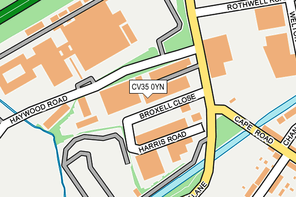
CV35 0YN is located in the Warwick All Saints & Woodloes electoral ward, within the local authority district of Warwick and the English Parliamentary constituency of Warwick and Leamington. The Sub Integrated Care Board (ICB) Location is NHS Coventry and Warwickshire ICB - B2M3M and the police force is Warwickshire. This postcode has been in use since June 2002.


GetTheData
Source: OS OpenMap – Local (Ordnance Survey)
Source: OS VectorMap District (Ordnance Survey)
Licence: Open Government Licence (requires attribution)
| Easting | 427278 |
| Northing | 266046 |
| Latitude | 52.291874 |
| Longitude | -1.601480 |
GetTheData
Source: Open Postcode Geo
Licence: Open Government Licence
| Country | England |
| Postcode District | CV35 |
➜ See where CV35 is on a map ➜ Where is Warwick? | |
GetTheData
Source: Land Registry Price Paid Data
Licence: Open Government Licence
Elevation or altitude of CV35 0YN as distance above sea level:
| Metres | Feet | |
|---|---|---|
| Elevation | 60m | 197ft |
Elevation is measured from the approximate centre of the postcode, to the nearest point on an OS contour line from OS Terrain 50, which has contour spacing of ten vertical metres.
➜ How high above sea level am I? Find the elevation of your current position using your device's GPS.
GetTheData
Source: Open Postcode Elevation
Licence: Open Government Licence
| Ward | Warwick All Saints & Woodloes |
| Constituency | Warwick And Leamington |
GetTheData
Source: ONS Postcode Database
Licence: Open Government Licence
| Ibm (Wedgnock Lane) | Warwick | 112m |
| Ibm (Wedgnock Lane) | Warwick | 144m |
| Saltisford Gardens (St Michaels Road) | Warwick | 391m |
| Lower Cape (Cape Road) | Warwick | 398m |
| Saltisford Gardens (St Michaels Road) | Warwick | 412m |
| Warwick Parkway Station | 1km |
| Warwick Station | 1.5km |
| Leamington Spa Station | 4.5km |
GetTheData
Source: NaPTAN
Licence: Open Government Licence
GetTheData
Source: ONS Postcode Database
Licence: Open Government Licence


➜ Get more ratings from the Food Standards Agency
GetTheData
Source: Food Standards Agency
Licence: FSA terms & conditions
| Last Collection | |||
|---|---|---|---|
| Location | Mon-Fri | Sat | Distance |
| Warwick Delivery Office | 19:00 | 12:30 | 29m |
| Saltisford Gardens | 16:00 | 11:15 | 429m |
| Stanks Hill | 17:15 | 10:15 | 491m |
GetTheData
Source: Dracos
Licence: Creative Commons Attribution-ShareAlike
The below table lists the International Territorial Level (ITL) codes (formerly Nomenclature of Territorial Units for Statistics (NUTS) codes) and Local Administrative Units (LAU) codes for CV35 0YN:
| ITL 1 Code | Name |
|---|---|
| TLG | West Midlands (England) |
| ITL 2 Code | Name |
| TLG1 | Herefordshire, Worcestershire and Warwickshire |
| ITL 3 Code | Name |
| TLG13 | Warwickshire CC |
| LAU 1 Code | Name |
| E07000222 | Warwick |
GetTheData
Source: ONS Postcode Directory
Licence: Open Government Licence
The below table lists the Census Output Area (OA), Lower Layer Super Output Area (LSOA), and Middle Layer Super Output Area (MSOA) for CV35 0YN:
| Code | Name | |
|---|---|---|
| OA | E00159666 | |
| LSOA | E01031312 | Warwick 008D |
| MSOA | E02006526 | Warwick 008 |
GetTheData
Source: ONS Postcode Directory
Licence: Open Government Licence
| CV34 5YA | Wedgnock Industrial Estate | 161m |
| CV34 5DX | Hanworth Road | 315m |
| CV34 5DS | Upper Cape | 321m |
| CV34 5AT | Chandley Wharf | 333m |
| CV34 5DT | Cape Road | 335m |
| CV34 5AU | Chandley Wharf | 337m |
| CV34 5PZ | Welton Road | 350m |
| CV34 5RR | Antelope Gardens | 365m |
| CV34 5DU | Landor Road | 365m |
| CV34 5EG | Chandley Row | 385m |
GetTheData
Source: Open Postcode Geo; Land Registry Price Paid Data
Licence: Open Government Licence