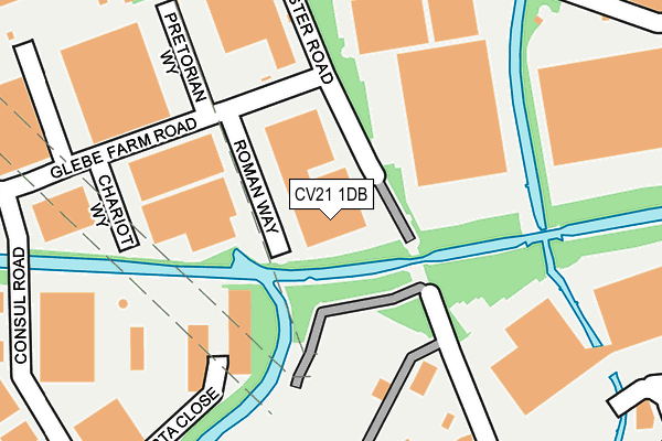
CV21 1DB lies on Roman Way in Glebe Farm Industrial Estate, Rugby. CV21 1DB is located in the Newbold and Brownsover electoral ward, within the local authority district of Rugby and the English Parliamentary constituency of Rugby. The Sub Integrated Care Board (ICB) Location is NHS Coventry and Warwickshire ICB - B2M3M and the police force is Warwickshire. This postcode has been in use since December 2000.


GetTheData
Source: OS OpenMap – Local (Ordnance Survey)
Source: OS VectorMap District (Ordnance Survey)
Licence: Open Government Licence (requires attribution)
| Easting | 450163 |
| Northing | 277112 |
| Latitude | 52.389760 |
| Longitude | -1.264310 |
GetTheData
Source: Open Postcode Geo
Licence: Open Government Licence
| Street | Roman Way |
| Locality | Glebe Farm Industrial Estate |
| Town/City | Rugby |
| Country | England |
| Postcode District | CV21 |
➜ See where CV21 is on a map ➜ Where is Rugby? | |
GetTheData
Source: Land Registry Price Paid Data
Licence: Open Government Licence
Elevation or altitude of CV21 1DB as distance above sea level:
| Metres | Feet | |
|---|---|---|
| Elevation | 90m | 295ft |
Elevation is measured from the approximate centre of the postcode, to the nearest point on an OS contour line from OS Terrain 50, which has contour spacing of ten vertical metres.
➜ How high above sea level am I? Find the elevation of your current position using your device's GPS.
GetTheData
Source: Open Postcode Elevation
Licence: Open Government Licence
| Ward | Newbold And Brownsover |
| Constituency | Rugby |
GetTheData
Source: ONS Postcode Database
Licence: Open Government Licence
| Roman Way (Glebe Farm Road) | Glebe Farm | 81m |
| Pretoriam Way (Glebe Farm Road) | Glebe Farm | 83m |
| Glebe Farm Road (Consul Road) | Glebe Farm | 184m |
| Glebe Farm Road (Consul Road) | Glebe Farm | 201m |
| Swift Park (Old Leicester Road) | Glebe Farm | 207m |
| Rugby Station | 1.5km |
GetTheData
Source: NaPTAN
Licence: Open Government Licence
GetTheData
Source: ONS Postcode Database
Licence: Open Government Licence

➜ Get more ratings from the Food Standards Agency
GetTheData
Source: Food Standards Agency
Licence: FSA terms & conditions
| Last Collection | |||
|---|---|---|---|
| Location | Mon-Fri | Sat | Distance |
| Glebe Farm Road Business Box | 104m | ||
| Tesco Supermarket | 17:30 | 11:45 | 574m |
| Star Farm | 17:30 | 12:30 | 704m |
GetTheData
Source: Dracos
Licence: Creative Commons Attribution-ShareAlike
The below table lists the International Territorial Level (ITL) codes (formerly Nomenclature of Territorial Units for Statistics (NUTS) codes) and Local Administrative Units (LAU) codes for CV21 1DB:
| ITL 1 Code | Name |
|---|---|
| TLG | West Midlands (England) |
| ITL 2 Code | Name |
| TLG1 | Herefordshire, Worcestershire and Warwickshire |
| ITL 3 Code | Name |
| TLG13 | Warwickshire CC |
| LAU 1 Code | Name |
| E07000220 | Rugby |
GetTheData
Source: ONS Postcode Directory
Licence: Open Government Licence
The below table lists the Census Output Area (OA), Lower Layer Super Output Area (LSOA), and Middle Layer Super Output Area (MSOA) for CV21 1DB:
| Code | Name | |
|---|---|---|
| OA | E00158731 | |
| LSOA | E01031141 | Rugby 002E |
| MSOA | E02006493 | Rugby 002 |
GetTheData
Source: ONS Postcode Directory
Licence: Open Government Licence
| CV21 1PB | Consul Road | 284m |
| CV21 1ED | Tiber Way | 301m |
| CV21 1DR | Quarry Close | 402m |
| CV21 1DW | Norman Road | 402m |
| CV21 1DN | Norman Road | 444m |
| CV21 1DT | Allesley Road | 480m |
| CV21 1DF | Yates Avenue | 485m |
| CV21 1DL | Norman Road | 501m |
| CV21 1AY | Egerton Close | 534m |
| CV21 1TF | Prospect Park | 541m |
GetTheData
Source: Open Postcode Geo; Land Registry Price Paid Data
Licence: Open Government Licence