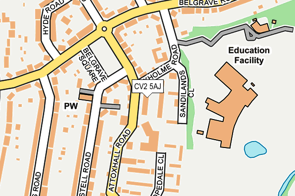
CV2 5AJ is located in the Wyken electoral ward, within the metropolitan district of Coventry and the English Parliamentary constituency of Coventry North East. The Sub Integrated Care Board (ICB) Location is NHS Coventry and Warwickshire ICB - B2M3M and the police force is West Midlands. This postcode has been in use since August 2020.


GetTheData
Source: OS OpenMap – Local (Ordnance Survey)
Source: OS VectorMap District (Ordnance Survey)
Licence: Open Government Licence (requires attribution)
| Easting | 437231 |
| Northing | 279642 |
| Latitude | 52.413534 |
| Longitude | -1.454047 |
GetTheData
Source: Open Postcode Geo
Licence: Open Government Licence
| Country | England |
| Postcode District | CV2 |
➜ See where CV2 is on a map ➜ Where is Coventry? | |
GetTheData
Source: Land Registry Price Paid Data
Licence: Open Government Licence
Elevation or altitude of CV2 5AJ as distance above sea level:
| Metres | Feet | |
|---|---|---|
| Elevation | 80m | 262ft |
Elevation is measured from the approximate centre of the postcode, to the nearest point on an OS contour line from OS Terrain 50, which has contour spacing of ten vertical metres.
➜ How high above sea level am I? Find the elevation of your current position using your device's GPS.
GetTheData
Source: Open Postcode Elevation
Licence: Open Government Licence
| Ward | Wyken |
| Constituency | Coventry North East |
GetTheData
Source: ONS Postcode Database
Licence: Open Government Licence
| Axholme Rd (Attoxhall Rd) | Wyken Green | 58m |
| Belgrave Lodge (Attoxhall Rd) | Wyken Green | 156m |
| Belgrave Lodge (Attoxhall Rd) | Wyken Green | 164m |
| Attoxhall Rd (Belgrave Rd) | Wyken Green | 167m |
| Attoxhall Rd (Belgrave Rd) | Wyken Green | 180m |
| Coventry Station | 4.3km |
| Coventry Arena Station | 4.7km |
GetTheData
Source: NaPTAN
Licence: Open Government Licence
Estimated total energy consumption in CV2 5AJ by fuel type, 2015.
| Consumption (kWh) | 79,681 |
|---|---|
| Meter count | 51 |
| Mean (kWh/meter) | 1,562 |
| Median (kWh/meter) | 1,123 |
GetTheData
Source: Postcode level gas estimates: 2015 (experimental)
Source: Postcode level electricity estimates: 2015 (experimental)
Licence: Open Government Licence
GetTheData
Source: ONS Postcode Database
Licence: Open Government Licence


➜ Get more ratings from the Food Standards Agency
GetTheData
Source: Food Standards Agency
Licence: FSA terms & conditions
| Last Collection | |||
|---|---|---|---|
| Location | Mon-Fri | Sat | Distance |
| Walsgrave On Sowe P.o. | 18:30 | 10:45 | 104m |
| Attoxhall Road | 16:45 | 10:45 | 373m |
| Mayflower Drive | 16:30 | 10:45 | 837m |
GetTheData
Source: Dracos
Licence: Creative Commons Attribution-ShareAlike
The below table lists the International Territorial Level (ITL) codes (formerly Nomenclature of Territorial Units for Statistics (NUTS) codes) and Local Administrative Units (LAU) codes for CV2 5AJ:
| ITL 1 Code | Name |
|---|---|
| TLG | West Midlands (England) |
| ITL 2 Code | Name |
| TLG3 | West Midlands |
| ITL 3 Code | Name |
| TLG33 | Coventry |
| LAU 1 Code | Name |
| E08000026 | Coventry |
GetTheData
Source: ONS Postcode Directory
Licence: Open Government Licence
The below table lists the Census Output Area (OA), Lower Layer Super Output Area (LSOA), and Middle Layer Super Output Area (MSOA) for CV2 5AJ:
| Code | Name | |
|---|---|---|
| OA | E00049138 | |
| LSOA | E01009718 | Coventry 019E |
| MSOA | E02001976 | Coventry 019 |
GetTheData
Source: ONS Postcode Directory
Licence: Open Government Licence
| CV2 5BB | Sandilands Close | 33m |
| CV2 5BA | Axholme Road | 53m |
| CV2 5AH | Attoxhall Road | 103m |
| CV2 5AL | Attoxhall Road | 116m |
| CV2 5BD | Axholme Road | 133m |
| CV2 5AE | St Austell Road | 136m |
| CV2 5AP | Hopedale Close | 141m |
| CV2 5AZ | Belgrave Square | 148m |
| CV2 5BE | Belgrave Road | 169m |
| CV2 5AY | Belgrave Road | 190m |
GetTheData
Source: Open Postcode Geo; Land Registry Price Paid Data
Licence: Open Government Licence