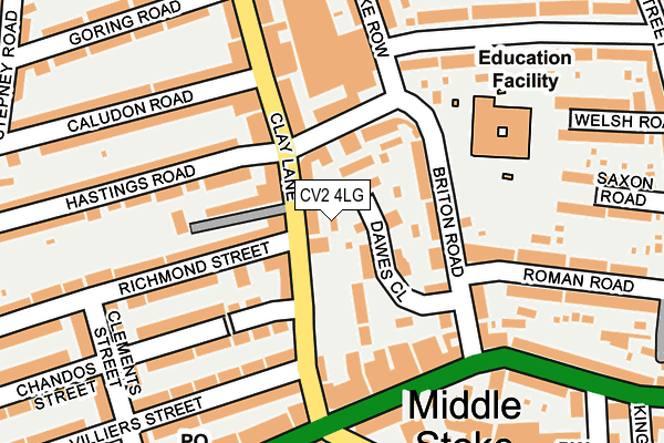
CV2 4LG is located in the Upper Stoke electoral ward, within the metropolitan district of Coventry and the English Parliamentary constituency of Coventry North East. The Sub Integrated Care Board (ICB) Location is NHS Coventry and Warwickshire ICB - B2M3M and the police force is West Midlands. This postcode has been in use since December 1999.


GetTheData
Source: OS OpenMap – Local (Ordnance Survey)
Source: OS VectorMap District (Ordnance Survey)
Licence: Open Government Licence (requires attribution)
| Easting | 435323 |
| Northing | 279528 |
| Latitude | 52.412618 |
| Longitude | -1.482118 |
GetTheData
Source: Open Postcode Geo
Licence: Open Government Licence
| Country | England |
| Postcode District | CV2 |
➜ See where CV2 is on a map ➜ Where is Coventry? | |
GetTheData
Source: Land Registry Price Paid Data
Licence: Open Government Licence
Elevation or altitude of CV2 4LG as distance above sea level:
| Metres | Feet | |
|---|---|---|
| Elevation | 90m | 295ft |
Elevation is measured from the approximate centre of the postcode, to the nearest point on an OS contour line from OS Terrain 50, which has contour spacing of ten vertical metres.
➜ How high above sea level am I? Find the elevation of your current position using your device's GPS.
GetTheData
Source: Open Postcode Elevation
Licence: Open Government Licence
| Ward | Upper Stoke |
| Constituency | Coventry North East |
GetTheData
Source: ONS Postcode Database
Licence: Open Government Licence
| Villiers St (Clay Lane) | Upper Stoke | 64m |
| Caludon Rd (Clay Lane) | Upper Stoke | 93m |
| Villiers St (Clay Lane) | Upper Stoke | 102m |
| Caludon Rd (Clay Lane) | Upper Stoke | 127m |
| Harefield Rd (Walsgrave Rd) | Upper Stoke | 244m |
| Coventry Station | 2.5km |
| Coventry Arena Station | 4km |
| Canley Station | 4.7km |
GetTheData
Source: NaPTAN
Licence: Open Government Licence
GetTheData
Source: ONS Postcode Database
Licence: Open Government Licence


➜ Get more ratings from the Food Standards Agency
GetTheData
Source: Food Standards Agency
Licence: FSA terms & conditions
| Last Collection | |||
|---|---|---|---|
| Location | Mon-Fri | Sat | Distance |
| Powell Road | 17:30 | 10:00 | 511m |
| Swan Lane | 16:30 | 09:45 | 573m |
| Paynes Lane | 18:45 | 09:45 | 767m |
GetTheData
Source: Dracos
Licence: Creative Commons Attribution-ShareAlike
The below table lists the International Territorial Level (ITL) codes (formerly Nomenclature of Territorial Units for Statistics (NUTS) codes) and Local Administrative Units (LAU) codes for CV2 4LG:
| ITL 1 Code | Name |
|---|---|
| TLG | West Midlands (England) |
| ITL 2 Code | Name |
| TLG3 | West Midlands |
| ITL 3 Code | Name |
| TLG33 | Coventry |
| LAU 1 Code | Name |
| E08000026 | Coventry |
GetTheData
Source: ONS Postcode Directory
Licence: Open Government Licence
The below table lists the Census Output Area (OA), Lower Layer Super Output Area (LSOA), and Middle Layer Super Output Area (MSOA) for CV2 4LG:
| Code | Name | |
|---|---|---|
| OA | E00048893 | |
| LSOA | E01009660 | Coventry 021D |
| MSOA | E02001978 | Coventry 021 |
GetTheData
Source: ONS Postcode Directory
Licence: Open Government Licence
| CV2 4LN | Clay Lane | 22m |
| CV2 4LJ | Clay Lane | 52m |
| CV2 4LL | Dawes Close | 55m |
| CV2 4LF | Briton Road | 90m |
| CV2 4RT | Westbury Mews | 100m |
| CV2 4JQ | Stoke Row | 103m |
| CV2 4RU | Briton Road | 129m |
| CV2 4JE | Hastings Road | 134m |
| CV2 4HZ | Richmond Street | 138m |
| CV2 4HY | Richmond Street | 149m |
GetTheData
Source: Open Postcode Geo; Land Registry Price Paid Data
Licence: Open Government Licence