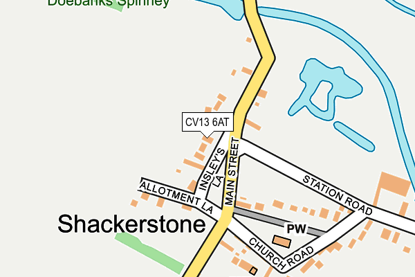
CV13 6AT is located in the Cadeby, Carlton and Market Bosworth with Shackerstone electoral ward, within the local authority district of Hinckley and Bosworth and the English Parliamentary constituency of Bosworth. The Sub Integrated Care Board (ICB) Location is NHS Leicester, Leicestershire and Rutland ICB - 04V and the police force is Leicestershire. This postcode has been in use since June 2017.


GetTheData
Source: OS OpenMap – Local (Ordnance Survey)
Source: OS VectorMap District (Ordnance Survey)
Licence: Open Government Licence (requires attribution)
| Easting | 437310 |
| Northing | 306884 |
| Latitude | 52.658420 |
| Longitude | -1.449835 |
GetTheData
Source: Open Postcode Geo
Licence: Open Government Licence
| Country | England |
| Postcode District | CV13 |
➜ See where CV13 is on a map ➜ Where is Shackerstone? | |
GetTheData
Source: Land Registry Price Paid Data
Licence: Open Government Licence
| Ward | Cadeby, Carlton And Market Bosworth With Shackerstone |
| Constituency | Bosworth |
GetTheData
Source: ONS Postcode Database
Licence: Open Government Licence
| Church Road (Main Street) | Shackerstone | 85m |
| Church Road (Main Street) | Shackerstone | 92m |
| Primary School (Gopsall Road) | Congerstone | 1,258m |
| Barton Road (Main Street) | Congerstone | 1,512m |
| Shackerstone Rail Station (Battlefield Line) | Shackerstone | 709m |
GetTheData
Source: NaPTAN
Licence: Open Government Licence
| Percentage of properties with Next Generation Access | 100.0% |
| Percentage of properties with Superfast Broadband | 100.0% |
| Percentage of properties with Ultrafast Broadband | 0.0% |
| Percentage of properties with Full Fibre Broadband | 0.0% |
Superfast Broadband is between 30Mbps and 300Mbps
Ultrafast Broadband is > 300Mbps
| Percentage of properties unable to receive 2Mbps | 0.0% |
| Percentage of properties unable to receive 5Mbps | 0.0% |
| Percentage of properties unable to receive 10Mbps | 0.0% |
| Percentage of properties unable to receive 30Mbps | 0.0% |
GetTheData
Source: Ofcom
Licence: Ofcom Terms of Use (requires attribution)
GetTheData
Source: ONS Postcode Database
Licence: Open Government Licence


➜ Get more ratings from the Food Standards Agency
GetTheData
Source: Food Standards Agency
Licence: FSA terms & conditions
| Last Collection | |||
|---|---|---|---|
| Location | Mon-Fri | Sat | Distance |
| Odd House Inn | 16:00 | 12:00 | 3,342m |
| Main Street | 16:15 | 12:00 | 3,717m |
| Railway Station | 16:45 | 10:45 | 4,266m |
GetTheData
Source: Dracos
Licence: Creative Commons Attribution-ShareAlike
The below table lists the International Territorial Level (ITL) codes (formerly Nomenclature of Territorial Units for Statistics (NUTS) codes) and Local Administrative Units (LAU) codes for CV13 6AT:
| ITL 1 Code | Name |
|---|---|
| TLF | East Midlands (England) |
| ITL 2 Code | Name |
| TLF2 | Leicestershire, Rutland and Northamptonshire |
| ITL 3 Code | Name |
| TLF22 | Leicestershire CC and Rutland |
| LAU 1 Code | Name |
| E07000132 | Hinckley and Bosworth |
GetTheData
Source: ONS Postcode Directory
Licence: Open Government Licence
The below table lists the Census Output Area (OA), Lower Layer Super Output Area (LSOA), and Middle Layer Super Output Area (MSOA) for CV13 6AT:
| Code | Name | |
|---|---|---|
| OA | E00131114 | |
| LSOA | E01025837 | Hinckley and Bosworth 004C |
| MSOA | E02005380 | Hinckley and Bosworth 004 |
GetTheData
Source: ONS Postcode Directory
Licence: Open Government Licence
| CV13 6NL | 50m | |
| CV13 6NR | Main Street | 87m |
| CV13 6NP | Church Walk | 156m |
| CV13 6NN | Church Road | 233m |
| CV13 6NZ | St Peters Place | 259m |
| CV13 0BS | 709m | |
| CV13 0BT | 1148m | |
| CV13 6NE | Poplar Terrace | 1376m |
| CV13 6NB | Barton Road | 1384m |
| CV13 6LX | Shackerstone Road | 1413m |
GetTheData
Source: Open Postcode Geo; Land Registry Price Paid Data
Licence: Open Government Licence