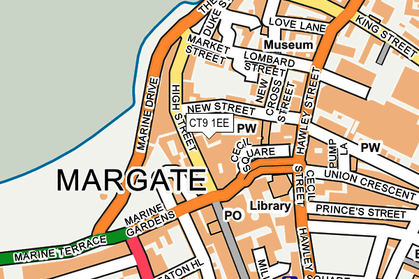
CT9 1EE is located in the Margate Central electoral ward, within the local authority district of Thanet and the English Parliamentary constituency of North Thanet. The Sub Integrated Care Board (ICB) Location is NHS Kent and Medway ICB - 91Q and the police force is Kent. This postcode has been in use since June 2012.


GetTheData
Source: OS OpenMap – Local (Ordnance Survey)
Source: OS VectorMap District (Ordnance Survey)
Licence: Open Government Licence (requires attribution)
| Easting | 635325 |
| Northing | 170891 |
| Latitude | 51.388244 |
| Longitude | 1.380934 |
GetTheData
Source: Open Postcode Geo
Licence: Open Government Licence
| Country | England |
| Postcode District | CT9 |
➜ See where CT9 is on a map ➜ Where is Margate? | |
GetTheData
Source: Land Registry Price Paid Data
Licence: Open Government Licence
Elevation or altitude of CT9 1EE as distance above sea level:
| Metres | Feet | |
|---|---|---|
| Elevation | 10m | 33ft |
Elevation is measured from the approximate centre of the postcode, to the nearest point on an OS contour line from OS Terrain 50, which has contour spacing of ten vertical metres.
➜ How high above sea level am I? Find the elevation of your current position using your device's GPS.
GetTheData
Source: Open Postcode Elevation
Licence: Open Government Licence
| Ward | Margate Central |
| Constituency | North Thanet |
GetTheData
Source: ONS Postcode Database
Licence: Open Government Licence
| Cecil Square (Queen Street) | Margate | 70m |
| Cecil Square (Queen Street) | Margate | 80m |
| Cecil Square (Queen Street) | Margate | 83m |
| Cecil Square (Queen Street) | Margate | 96m |
| Clock Tower (Marine Drive) | Margate | 122m |
| Margate Station | 0.7km |
| Westgate-on-Sea Station | 3.1km |
| Broadstairs Station | 4.8km |
GetTheData
Source: NaPTAN
Licence: Open Government Licence
GetTheData
Source: ONS Postcode Database
Licence: Open Government Licence


➜ Get more ratings from the Food Standards Agency
GetTheData
Source: Food Standards Agency
Licence: FSA terms & conditions
| Last Collection | |||
|---|---|---|---|
| Location | Mon-Fri | Sat | Distance |
| High Street | 18:30 | 11:45 | 40m |
| Cecil Square | 18:30 | 11:45 | 60m |
| Parade | 18:30 | 11:00 | 142m |
GetTheData
Source: Dracos
Licence: Creative Commons Attribution-ShareAlike
The below table lists the International Territorial Level (ITL) codes (formerly Nomenclature of Territorial Units for Statistics (NUTS) codes) and Local Administrative Units (LAU) codes for CT9 1EE:
| ITL 1 Code | Name |
|---|---|
| TLJ | South East (England) |
| ITL 2 Code | Name |
| TLJ4 | Kent |
| ITL 3 Code | Name |
| TLJ44 | East Kent |
| LAU 1 Code | Name |
| E07000114 | Thanet |
GetTheData
Source: ONS Postcode Directory
Licence: Open Government Licence
The below table lists the Census Output Area (OA), Lower Layer Super Output Area (LSOA), and Middle Layer Super Output Area (MSOA) for CT9 1EE:
| Code | Name | |
|---|---|---|
| OA | E00125263 | |
| LSOA | E01024678 | Thanet 001E |
| MSOA | E02005132 | Thanet 001 |
GetTheData
Source: ONS Postcode Directory
Licence: Open Government Licence
| CT9 1DX | High Street | 24m |
| CT9 1EG | New Street | 36m |
| CT9 1DT | High Street | 52m |
| CT9 1UJ | Albert Terrace | 86m |
| CT9 1DL | High Street | 87m |
| CT9 1DS | High Street | 89m |
| CT9 1DH | Marine Drive | 99m |
| CT9 1UH | Marine Gardens | 100m |
| CT9 1EH | New Cross Street | 102m |
| CT9 1EU | Market Street | 111m |
GetTheData
Source: Open Postcode Geo; Land Registry Price Paid Data
Licence: Open Government Licence