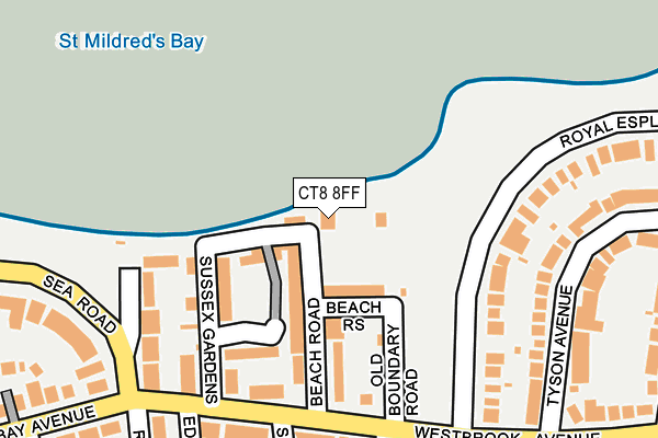
CT8 8FF is located in the Westgate-on-Sea electoral ward, within the local authority district of Thanet and the English Parliamentary constituency of North Thanet. The Sub Integrated Care Board (ICB) Location is NHS Kent and Medway ICB - 91Q and the police force is Kent. This postcode has been in use since March 2017.


GetTheData
Source: OS OpenMap – Local (Ordnance Survey)
Source: OS VectorMap District (Ordnance Survey)
Licence: Open Government Licence (requires attribution)
| Easting | 632797 |
| Northing | 170390 |
| Latitude | 51.384788 |
| Longitude | 1.344339 |
GetTheData
Source: Open Postcode Geo
Licence: Open Government Licence
| Country | England |
| Postcode District | CT8 |
➜ See where CT8 is on a map ➜ Where is Margate? | |
GetTheData
Source: Land Registry Price Paid Data
Licence: Open Government Licence
| Ward | Westgate-on-sea |
| Constituency | North Thanet |
GetTheData
Source: ONS Postcode Database
Licence: Open Government Licence
| Norman Road (Westbrook Avenue) | Westbrook | 207m |
| Norman Road (Westbrook Avenue) | Westbrook | 210m |
| Roxburgh Road | Westgate-on-sea | 259m |
| Adrian Square (Westgate Bay Avenue) | Westgate-on-sea | 289m |
| Bowes Avenue (Westbrook Avenue) | Westbrook | 388m |
| Westgate-on-Sea Station | 0.6km |
| Margate Station | 1.9km |
| Birchington-on-Sea Station | 3.1km |
GetTheData
Source: NaPTAN
Licence: Open Government Licence
GetTheData
Source: ONS Postcode Database
Licence: Open Government Licence


➜ Get more ratings from the Food Standards Agency
GetTheData
Source: Food Standards Agency
Licence: FSA terms & conditions
| Last Collection | |||
|---|---|---|---|
| Location | Mon-Fri | Sat | Distance |
| Sussex Gardens | 16:15 | 11:45 | 190m |
| Sea Road | 16:15 | 11:45 | 317m |
| Bowes Avenue | 16:00 | 11:30 | 390m |
GetTheData
Source: Dracos
Licence: Creative Commons Attribution-ShareAlike
The below table lists the International Territorial Level (ITL) codes (formerly Nomenclature of Territorial Units for Statistics (NUTS) codes) and Local Administrative Units (LAU) codes for CT8 8FF:
| ITL 1 Code | Name |
|---|---|
| TLJ | South East (England) |
| ITL 2 Code | Name |
| TLJ4 | Kent |
| ITL 3 Code | Name |
| TLJ44 | East Kent |
| LAU 1 Code | Name |
| E07000114 | Thanet |
GetTheData
Source: ONS Postcode Directory
Licence: Open Government Licence
The below table lists the Census Output Area (OA), Lower Layer Super Output Area (LSOA), and Middle Layer Super Output Area (MSOA) for CT8 8FF:
| Code | Name | |
|---|---|---|
| OA | E00125456 | |
| LSOA | E01024715 | Thanet 007D |
| MSOA | E02005138 | Thanet 007 |
GetTheData
Source: ONS Postcode Directory
Licence: Open Government Licence
| CT8 8AU | St Mildreds Mews | 64m |
| CT8 8AB | Beach Rise | 69m |
| CT8 8AE | Beach Road | 85m |
| CT8 8AD | Beach Road | 94m |
| CT8 8BB | Sussex Gardens | 109m |
| CT8 8AQ | Sussex Mansions | 117m |
| CT8 8DJ | Sussex Gardens | 130m |
| CT8 8TJ | Waterside Drive | 142m |
| CT8 8AA | Old Boundary Road | 142m |
| CT8 8DU | Sussex Gardens | 145m |
GetTheData
Source: Open Postcode Geo; Land Registry Price Paid Data
Licence: Open Government Licence