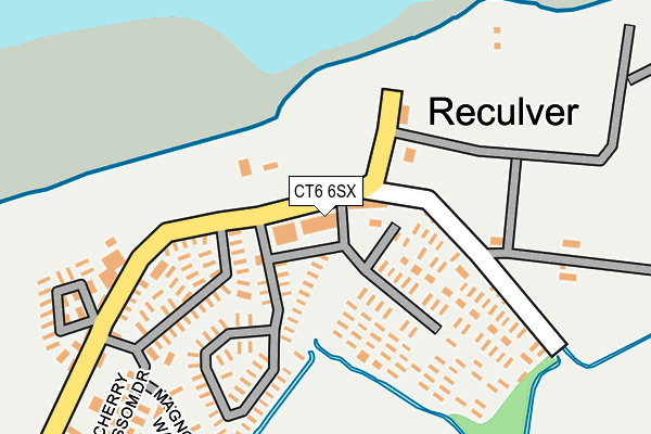
CT6 6SX is located in the Reculver electoral ward, within the local authority district of Canterbury and the English Parliamentary constituency of North Thanet. The Sub Integrated Care Board (ICB) Location is NHS Kent and Medway ICB - 91Q and the police force is Kent. This postcode has been in use since January 1980.


GetTheData
Source: OS OpenMap – Local (Ordnance Survey)
Source: OS VectorMap District (Ordnance Survey)
Licence: Open Government Licence (requires attribution)
| Easting | 622592 |
| Northing | 169192 |
| Latitude | 51.378123 |
| Longitude | 1.197178 |
GetTheData
Source: Open Postcode Geo
Licence: Open Government Licence
| Country | England |
| Postcode District | CT6 |
➜ See where CT6 is on a map ➜ Where is Reculver? | |
GetTheData
Source: Land Registry Price Paid Data
Licence: Open Government Licence
Elevation or altitude of CT6 6SX as distance above sea level:
| Metres | Feet | |
|---|---|---|
| Elevation | 10m | 33ft |
Elevation is measured from the approximate centre of the postcode, to the nearest point on an OS contour line from OS Terrain 50, which has contour spacing of ten vertical metres.
➜ How high above sea level am I? Find the elevation of your current position using your device's GPS.
GetTheData
Source: Open Postcode Elevation
Licence: Open Government Licence
| Ward | Reculver |
| Constituency | North Thanet |
GetTheData
Source: ONS Postcode Database
Licence: Open Government Licence
| Cafe (Reculver Lane) | Reculver | 44m |
| King Ethelbert (Reculver Lane) | Reculver | 125m |
| Blue Dolphin Park (Reculver Lane) | Reculver | 158m |
| Blue Dolphin Park (Reculver Lane) | Reculver | 170m |
| Reculver School (Reculver Lane) | Hillborough | 1,870m |
GetTheData
Source: NaPTAN
Licence: Open Government Licence
GetTheData
Source: ONS Postcode Database
Licence: Open Government Licence


➜ Get more ratings from the Food Standards Agency
GetTheData
Source: Food Standards Agency
Licence: FSA terms & conditions
| Last Collection | |||
|---|---|---|---|
| Location | Mon-Fri | Sat | Distance |
| Reculver Towers | 16:30 | 10:30 | 56m |
| Hillborough | 16:30 | 10:30 | 1,932m |
| Bishopstone | 16:30 | 10:30 | 1,941m |
GetTheData
Source: Dracos
Licence: Creative Commons Attribution-ShareAlike
| Risk of CT6 6SX flooding from rivers and sea | High |
| ➜ CT6 6SX flood map | |
GetTheData
Source: Open Flood Risk by Postcode
Licence: Open Government Licence
The below table lists the International Territorial Level (ITL) codes (formerly Nomenclature of Territorial Units for Statistics (NUTS) codes) and Local Administrative Units (LAU) codes for CT6 6SX:
| ITL 1 Code | Name |
|---|---|
| TLJ | South East (England) |
| ITL 2 Code | Name |
| TLJ4 | Kent |
| ITL 3 Code | Name |
| TLJ44 | East Kent |
| LAU 1 Code | Name |
| E07000106 | Canterbury |
GetTheData
Source: ONS Postcode Directory
Licence: Open Government Licence
The below table lists the Census Output Area (OA), Lower Layer Super Output Area (LSOA), and Middle Layer Super Output Area (MSOA) for CT6 6SX:
| Code | Name | |
|---|---|---|
| OA | E00122332 | |
| LSOA | E01024094 | Canterbury 002A |
| MSOA | E02005011 | Canterbury 002 |
GetTheData
Source: ONS Postcode Directory
Licence: Open Government Licence
| CT6 6TT | Brook Lane | 1092m |
| CT6 6SZ | Brook Lane | 1416m |
| CT6 6EZ | Brook Lane | 1459m |
| CT3 4EN | North Stream | 1561m |
| CT3 4EL | 1605m | |
| CT6 6RL | Bishopstone Lane | 1663m |
| CT6 6TR | Manor Close | 1715m |
| CT6 6RG | Haven Drive | 1757m |
| CT6 6RW | Reculver Close | 1843m |
| CT6 6RN | Bishopstone Lane | 1847m |
GetTheData
Source: Open Postcode Geo; Land Registry Price Paid Data
Licence: Open Government Licence