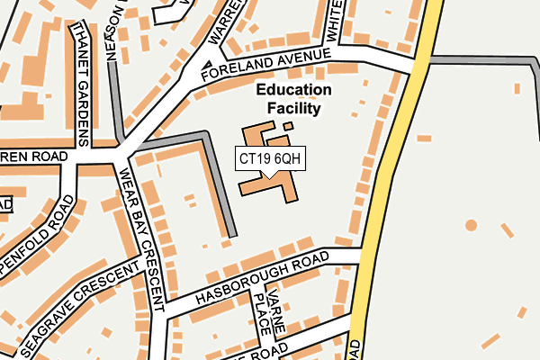
CT19 6QH is located in the Folkestone Harbour electoral ward, within the local authority district of Folkestone and Hythe and the English Parliamentary constituency of Folkestone and Hythe. The Sub Integrated Care Board (ICB) Location is NHS Kent and Medway ICB - 91Q and the police force is Kent. This postcode has been in use since January 1980.


GetTheData
Source: OS OpenMap – Local (Ordnance Survey)
Source: OS VectorMap District (Ordnance Survey)
Licence: Open Government Licence (requires attribution)
| Easting | 623841 |
| Northing | 136685 |
| Latitude | 51.085786 |
| Longitude | 1.194774 |
GetTheData
Source: Open Postcode Geo
Licence: Open Government Licence
| Country | England |
| Postcode District | CT19 |
➜ See where CT19 is on a map ➜ Where is Folkestone? | |
GetTheData
Source: Land Registry Price Paid Data
Licence: Open Government Licence
Elevation or altitude of CT19 6QH as distance above sea level:
| Metres | Feet | |
|---|---|---|
| Elevation | 30m | 98ft |
Elevation is measured from the approximate centre of the postcode, to the nearest point on an OS contour line from OS Terrain 50, which has contour spacing of ten vertical metres.
➜ How high above sea level am I? Find the elevation of your current position using your device's GPS.
GetTheData
Source: Open Postcode Elevation
Licence: Open Government Licence
| Ward | Folkestone Harbour |
| Constituency | Folkestone And Hythe |
GetTheData
Source: ONS Postcode Database
Licence: Open Government Licence
| Foreland Avenue | East Cliff | 142m |
| Seagrave Crescent (Wear Bay Crescent) | East Cliff | 145m |
| Foreland Avenue (Warren Way) | East Cliff | 148m |
| Seagrave Crescent (Wear Bay Crescent) | East Cliff | 161m |
| Bowls Club (Wear Bay Road) | East Cliff | 232m |
| Folkestone Central Station | 1.8km |
| Folkestone West Station | 2.9km |
GetTheData
Source: NaPTAN
Licence: Open Government Licence
GetTheData
Source: ONS Postcode Database
Licence: Open Government Licence


➜ Get more ratings from the Food Standards Agency
GetTheData
Source: Food Standards Agency
Licence: FSA terms & conditions
| Last Collection | |||
|---|---|---|---|
| Location | Mon-Fri | Sat | Distance |
| East Cliff Pavilion | 17:45 | 12:00 | 227m |
| Warren Road Post Office | 18:00 | 12:00 | 255m |
| Wear Bay Crescent | 17:45 | 12:00 | 353m |
GetTheData
Source: Dracos
Licence: Creative Commons Attribution-ShareAlike
The below table lists the International Territorial Level (ITL) codes (formerly Nomenclature of Territorial Units for Statistics (NUTS) codes) and Local Administrative Units (LAU) codes for CT19 6QH:
| ITL 1 Code | Name |
|---|---|
| TLJ | South East (England) |
| ITL 2 Code | Name |
| TLJ4 | Kent |
| ITL 3 Code | Name |
| TLJ44 | East Kent |
| LAU 1 Code | Name |
| E07000112 | Folkestone and Hythe |
GetTheData
Source: ONS Postcode Directory
Licence: Open Government Licence
The below table lists the Census Output Area (OA), Lower Layer Super Output Area (LSOA), and Middle Layer Super Output Area (MSOA) for CT19 6QH:
| Code | Name | |
|---|---|---|
| OA | E00124377 | |
| LSOA | E01024503 | Shepway 003D |
| MSOA | E02005104 | Shepway 003 |
GetTheData
Source: ONS Postcode Directory
Licence: Open Government Licence
| CT19 6BQ | Hasborough Road | 80m |
| CT19 6BH | Wear Bay Road | 99m |
| CT19 6PY | Wear Bay Road | 119m |
| CT19 6DU | Foreland Avenue | 120m |
| CT19 6DS | Foreland Avenue | 130m |
| CT19 6BD | Hasborough Road | 145m |
| CT19 6BJ | Wear Bay Road | 148m |
| CT19 6DY | Foreland Avenue | 154m |
| CT19 6BE | Varne Road | 166m |
| CT19 6BA | Wear Bay Crescent | 170m |
GetTheData
Source: Open Postcode Geo; Land Registry Price Paid Data
Licence: Open Government Licence