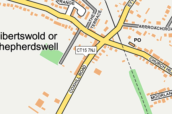
CT15 7NJ lies on Connaught Villas in Shepherdswell, Dover. CT15 7NJ is located in the Aylesham, Eythorne & Shepherdswell electoral ward, within the local authority district of Dover and the English Parliamentary constituency of Dover. The Sub Integrated Care Board (ICB) Location is NHS Kent and Medway ICB - 91Q and the police force is Kent. This postcode has been in use since January 1980.


GetTheData
Source: OS OpenMap – Local (Ordnance Survey)
Source: OS VectorMap District (Ordnance Survey)
Licence: Open Government Licence (requires attribution)
| Easting | 625729 |
| Northing | 147949 |
| Latitude | 51.186172 |
| Longitude | 1.228738 |
GetTheData
Source: Open Postcode Geo
Licence: Open Government Licence
| Street | Connaught Villas |
| Locality | Shepherdswell |
| Town/City | Dover |
| Country | England |
| Postcode District | CT15 |
➜ See where CT15 is on a map ➜ Where is Sibertswold? | |
GetTheData
Source: Land Registry Price Paid Data
Licence: Open Government Licence
Elevation or altitude of CT15 7NJ as distance above sea level:
| Metres | Feet | |
|---|---|---|
| Elevation | 90m | 295ft |
Elevation is measured from the approximate centre of the postcode, to the nearest point on an OS contour line from OS Terrain 50, which has contour spacing of ten vertical metres.
➜ How high above sea level am I? Find the elevation of your current position using your device's GPS.
GetTheData
Source: Open Postcode Elevation
Licence: Open Government Licence
| Ward | Aylesham, Eythorne & Shepherdswell |
| Constituency | Dover |
GetTheData
Source: ONS Postcode Database
Licence: Open Government Licence
| Co-op (Eythorne Road) | Shepherdswell | 129m |
| Railway Station (Station Road) | Shepherdswell | 252m |
| The Glen (Eythorne Road) | Shepherdswell | 424m |
| The Glen (Eythorne Road) | Shepherdswell | 437m |
| The Bell (Coldred Road) | Shepherdswell | 467m |
| Shepherdswell Station (East Kent Railway) | Shepherdswell | 405m |
| Shepherds Well Station | 0.3km |
| Snowdown Station | 3.4km |
| Aylesham Station | 4.8km |
GetTheData
Source: NaPTAN
Licence: Open Government Licence
| Percentage of properties with Next Generation Access | 100.0% |
| Percentage of properties with Superfast Broadband | 100.0% |
| Percentage of properties with Ultrafast Broadband | 0.0% |
| Percentage of properties with Full Fibre Broadband | 0.0% |
Superfast Broadband is between 30Mbps and 300Mbps
Ultrafast Broadband is > 300Mbps
| Percentage of properties unable to receive 2Mbps | 0.0% |
| Percentage of properties unable to receive 5Mbps | 0.0% |
| Percentage of properties unable to receive 10Mbps | 0.0% |
| Percentage of properties unable to receive 30Mbps | 0.0% |
GetTheData
Source: Ofcom
Licence: Ofcom Terms of Use (requires attribution)
GetTheData
Source: ONS Postcode Database
Licence: Open Government Licence


➜ Get more ratings from the Food Standards Agency
GetTheData
Source: Food Standards Agency
Licence: FSA terms & conditions
| Last Collection | |||
|---|---|---|---|
| Location | Mon-Fri | Sat | Distance |
| Shepherdswell Post Office | 17:00 | 11:00 | 167m |
| Eythorne Road | 16:00 | 09:30 | 443m |
| Church Hill | 16:00 | 09:00 | 470m |
GetTheData
Source: Dracos
Licence: Creative Commons Attribution-ShareAlike
The below table lists the International Territorial Level (ITL) codes (formerly Nomenclature of Territorial Units for Statistics (NUTS) codes) and Local Administrative Units (LAU) codes for CT15 7NJ:
| ITL 1 Code | Name |
|---|---|
| TLJ | South East (England) |
| ITL 2 Code | Name |
| TLJ4 | Kent |
| ITL 3 Code | Name |
| TLJ44 | East Kent |
| LAU 1 Code | Name |
| E07000108 | Dover |
GetTheData
Source: ONS Postcode Directory
Licence: Open Government Licence
The below table lists the Census Output Area (OA), Lower Layer Super Output Area (LSOA), and Middle Layer Super Output Area (MSOA) for CT15 7NJ:
| Code | Name | |
|---|---|---|
| OA | E00122881 | |
| LSOA | E01024203 | Dover 008B |
| MSOA | E02005048 | Dover 008 |
GetTheData
Source: ONS Postcode Directory
Licence: Open Government Licence
| CT15 7NL | Courtwood Villas | 14m |
| CT15 7NN | Cox Hill | 37m |
| CT15 7NW | Prospect Cottages | 43m |
| CT15 7NH | Whittington Terrace | 44m |
| CT15 7PS | Westcourt Lane | 79m |
| CT15 7NU | Eythorne Road | 115m |
| CT15 7PX | The Terrace | 127m |
| CT15 7NP | Church Hill | 166m |
| CT15 7QB | The Grange | 186m |
| CT15 7NY | Approach Road | 199m |
GetTheData
Source: Open Postcode Geo; Land Registry Price Paid Data
Licence: Open Government Licence