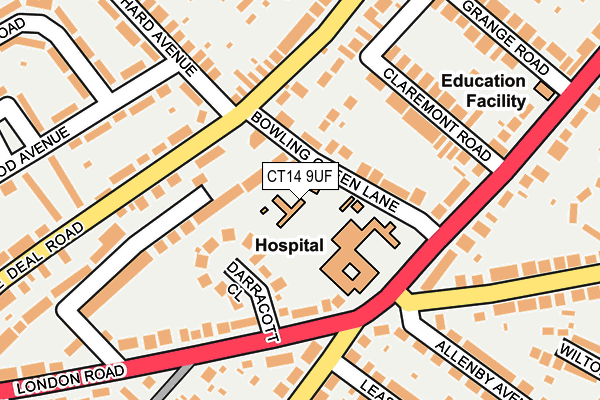
CT14 9UF is located in the Middle Deal electoral ward, within the local authority district of Dover and the English Parliamentary constituency of Dover. The Sub Integrated Care Board (ICB) Location is NHS Kent and Medway ICB - 91Q and the police force is Kent. This postcode has been in use since September 2004.


GetTheData
Source: OS OpenMap – Local (Ordnance Survey)
Source: OS VectorMap District (Ordnance Survey)
Licence: Open Government Licence (requires attribution)
| Easting | 636748 |
| Northing | 152198 |
| Latitude | 51.219867 |
| Longitude | 1.388959 |
GetTheData
Source: Open Postcode Geo
Licence: Open Government Licence
| Country | England |
| Postcode District | CT14 |
➜ See where CT14 is on a map ➜ Where is Deal? | |
GetTheData
Source: Land Registry Price Paid Data
Licence: Open Government Licence
Elevation or altitude of CT14 9UF as distance above sea level:
| Metres | Feet | |
|---|---|---|
| Elevation | 10m | 33ft |
Elevation is measured from the approximate centre of the postcode, to the nearest point on an OS contour line from OS Terrain 50, which has contour spacing of ten vertical metres.
➜ How high above sea level am I? Find the elevation of your current position using your device's GPS.
GetTheData
Source: Open Postcode Elevation
Licence: Open Government Licence
| Ward | Middle Deal |
| Constituency | Dover |
GetTheData
Source: ONS Postcode Database
Licence: Open Government Licence
| Bowling Green Lane Victoria Hospital (Bowling Green Lane) | Middle Deal | 62m |
| Bowling Green Lane Victoria Hospital (Bowling Green Lane) | Middle Deal | 69m |
| Orchard Avenue (Middle Deal Road) | Middle Deal | 103m |
| Victoria Hospital (London Road) | Middle Deal | 120m |
| Orchard Avenue (Middle Deal Road) | Middle Deal | 120m |
| Deal Station | 0.8km |
| Walmer Station | 1.9km |
GetTheData
Source: NaPTAN
Licence: Open Government Licence
GetTheData
Source: ONS Postcode Database
Licence: Open Government Licence


➜ Get more ratings from the Food Standards Agency
GetTheData
Source: Food Standards Agency
Licence: FSA terms & conditions
| Last Collection | |||
|---|---|---|---|
| Location | Mon-Fri | Sat | Distance |
| St Leonards Road | 16:00 | 10:30 | 148m |
| Opposite Church Path | 16:00 | 10:30 | 168m |
| Orchard Avenue | 16:00 | 10:30 | 195m |
GetTheData
Source: Dracos
Licence: Creative Commons Attribution-ShareAlike
The below table lists the International Territorial Level (ITL) codes (formerly Nomenclature of Territorial Units for Statistics (NUTS) codes) and Local Administrative Units (LAU) codes for CT14 9UF:
| ITL 1 Code | Name |
|---|---|
| TLJ | South East (England) |
| ITL 2 Code | Name |
| TLJ4 | Kent |
| ITL 3 Code | Name |
| TLJ44 | East Kent |
| LAU 1 Code | Name |
| E07000108 | Dover |
GetTheData
Source: ONS Postcode Directory
Licence: Open Government Licence
The below table lists the Census Output Area (OA), Lower Layer Super Output Area (LSOA), and Middle Layer Super Output Area (MSOA) for CT14 9UF:
| Code | Name | |
|---|---|---|
| OA | E00122952 | |
| LSOA | E01024221 | Dover 003C |
| MSOA | E02005043 | Dover 003 |
GetTheData
Source: ONS Postcode Directory
Licence: Open Government Licence
| CT14 9UB | Bowling Green Lane | 49m |
| CT14 9PU | Darracott Close | 95m |
| CT14 9TU | Church Path | 107m |
| CT14 9TX | Claremont Road | 122m |
| CT14 9PL | London Road | 148m |
| CT14 9TZ | London Road | 151m |
| CT14 9RN | Orchard Avenue | 157m |
| CT14 9SW | Middle Deal Road | 160m |
| CT14 9UD | Church Path | 163m |
| CT14 9RL | Middle Deal Road | 171m |
GetTheData
Source: Open Postcode Geo; Land Registry Price Paid Data
Licence: Open Government Licence