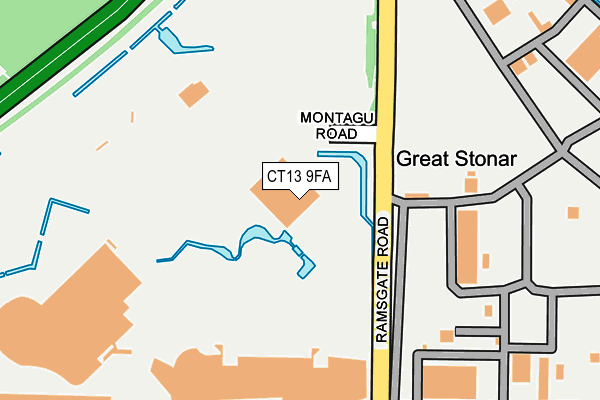
CT13 9FA is located in the Sandwich electoral ward, within the local authority district of Dover and the English Parliamentary constituency of South Thanet. The Sub Integrated Care Board (ICB) Location is NHS Kent and Medway ICB - 91Q and the police force is Kent. This postcode has been in use since June 2017.


GetTheData
Source: OS OpenMap – Local (Ordnance Survey)
Source: OS VectorMap District (Ordnance Survey)
Licence: Open Government Licence (requires attribution)
| Easting | 632806 |
| Northing | 159536 |
| Latitude | 51.287356 |
| Longitude | 1.337381 |
GetTheData
Source: Open Postcode Geo
Licence: Open Government Licence
| Country | England |
| Postcode District | CT13 |
➜ See where CT13 is on a map | |
GetTheData
Source: Land Registry Price Paid Data
Licence: Open Government Licence
| Ward | Sandwich |
| Constituency | South Thanet |
GetTheData
Source: ONS Postcode Database
Licence: Open Government Licence
| Pfizer Complex (Ramsgate Road) | Sandwich | 613m |
| Pfizer Complex (Ramsgate Road) | Sandwich | 630m |
| Fire Station (Ash Road) | Sandwich | 1,019m |
| Industrial Estate (Ramsgate Road) | Sandwich | 1,023m |
| Fire Station (Ash Road) | Sandwich | 1,033m |
| Sandwich Station | 2km |
| Minster Station | 4.9km |
GetTheData
Source: NaPTAN
Licence: Open Government Licence
GetTheData
Source: ONS Postcode Database
Licence: Open Government Licence


➜ Get more ratings from the Food Standards Agency
GetTheData
Source: Food Standards Agency
Licence: FSA terms & conditions
| Last Collection | |||
|---|---|---|---|
| Location | Mon-Fri | Sat | Distance |
| Ash Road | 17:15 | 11:30 | 1,021m |
| Strand Street | 17:15 | 11:30 | 1,069m |
| Stonar Industrial Estate | 16:00 | 11:30 | 1,143m |
GetTheData
Source: Dracos
Licence: Creative Commons Attribution-ShareAlike
The below table lists the International Territorial Level (ITL) codes (formerly Nomenclature of Territorial Units for Statistics (NUTS) codes) and Local Administrative Units (LAU) codes for CT13 9FA:
| ITL 1 Code | Name |
|---|---|
| TLJ | South East (England) |
| ITL 2 Code | Name |
| TLJ4 | Kent |
| ITL 3 Code | Name |
| TLJ44 | East Kent |
| LAU 1 Code | Name |
| E07000108 | Dover |
GetTheData
Source: ONS Postcode Directory
Licence: Open Government Licence
The below table lists the Census Output Area (OA), Lower Layer Super Output Area (LSOA), and Middle Layer Super Output Area (MSOA) for CT13 9FA:
| Code | Name | |
|---|---|---|
| OA | E00123065 | |
| LSOA | E01024244 | Dover 002D |
| MSOA | E02005042 | Dover 002 |
GetTheData
Source: ONS Postcode Directory
Licence: Open Government Licence
| CT13 9ND | Ramsgate Road | 626m |
| CT13 9JG | Richborough Road | 638m |
| CT13 9JQ | Richborough Hill | 660m |
| CT13 9JE | Richborough Road | 874m |
| CT13 9JF | Wantsume Lees | 915m |
| CT13 9JD | Mill Close | 988m |
| CT13 9HX | Strand Street | 1017m |
| CT13 9HP | Strand Street | 1051m |
| CT13 9JA | Ash Road | 1057m |
| CT13 9JL | Castle Road | 1080m |
GetTheData
Source: Open Postcode Geo; Land Registry Price Paid Data
Licence: Open Government Licence