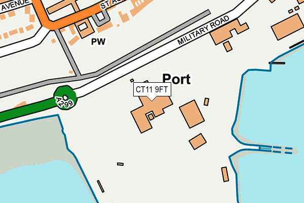
CT11 9FT is located in the Central Harbour electoral ward, within the local authority district of Thanet and the English Parliamentary constituency of South Thanet. The Sub Integrated Care Board (ICB) Location is NHS Kent and Medway ICB - 91Q and the police force is Kent. This postcode has been in use since December 1999.


GetTheData
Source: OS OpenMap – Local (Ordnance Survey)
Source: OS VectorMap District (Ordnance Survey)
Licence: Open Government Licence (requires attribution)
| Easting | 637801 |
| Northing | 164188 |
| Latitude | 51.327042 |
| Longitude | 1.411950 |
GetTheData
Source: Open Postcode Geo
Licence: Open Government Licence
| Country | England |
| Postcode District | CT11 |
➜ See where CT11 is on a map ➜ Where is Ramsgate? | |
GetTheData
Source: Land Registry Price Paid Data
Licence: Open Government Licence
Elevation or altitude of CT11 9FT as distance above sea level:
| Metres | Feet | |
|---|---|---|
| Elevation | 10m | 33ft |
Elevation is measured from the approximate centre of the postcode, to the nearest point on an OS contour line from OS Terrain 50, which has contour spacing of ten vertical metres.
➜ How high above sea level am I? Find the elevation of your current position using your device's GPS.
GetTheData
Source: Open Postcode Elevation
Licence: Open Government Licence
| Ward | Central Harbour |
| Constituency | South Thanet |
GetTheData
Source: ONS Postcode Database
Licence: Open Government Licence
| St Augustine's Abbey (St Augustine's Road) | Ramsgate | 204m |
| St Augustine's Abbey (St Augustine's Road) | Ramsgate | 222m |
| Addington Street (Paragon) | Ramsgate | 375m |
| Addington Street (Paragon) | Ramsgate | 392m |
| Cannonbury Road (West Cliff Road) | Ramsgate | 423m |
| Ramsgate Station | 1.6km |
| Dumpton Park Station | 2.3km |
| Broadstairs Station | 4km |
GetTheData
Source: NaPTAN
Licence: Open Government Licence
GetTheData
Source: ONS Postcode Database
Licence: Open Government Licence


➜ Get more ratings from the Food Standards Agency
GetTheData
Source: Food Standards Agency
Licence: FSA terms & conditions
| Last Collection | |||
|---|---|---|---|
| Location | Mon-Fri | Sat | Distance |
| Port Ramsgate | 17:00 | 11:45 | 23m |
| St Augustines Road | 17:30 | 11:30 | 236m |
| Royal Road | 17:30 | 11:30 | 283m |
GetTheData
Source: Dracos
Licence: Creative Commons Attribution-ShareAlike
The below table lists the International Territorial Level (ITL) codes (formerly Nomenclature of Territorial Units for Statistics (NUTS) codes) and Local Administrative Units (LAU) codes for CT11 9FT:
| ITL 1 Code | Name |
|---|---|
| TLJ | South East (England) |
| ITL 2 Code | Name |
| TLJ4 | Kent |
| ITL 3 Code | Name |
| TLJ44 | East Kent |
| LAU 1 Code | Name |
| E07000114 | Thanet |
GetTheData
Source: ONS Postcode Directory
Licence: Open Government Licence
The below table lists the Census Output Area (OA), Lower Layer Super Output Area (LSOA), and Middle Layer Super Output Area (MSOA) for CT11 9FT:
| Code | Name | |
|---|---|---|
| OA | E00125111 | |
| LSOA | E01024649 | Thanet 016C |
| MSOA | E02005147 | Thanet 016 |
GetTheData
Source: ONS Postcode Directory
Licence: Open Government Licence
| CT11 9NZ | Chartham Terrace | 174m |
| CT11 9NY | St Augustines Road | 191m |
| CT11 9PN | St Augustines Road | 211m |
| CT11 9PD | Royal Crescent | 230m |
| CT11 9PJ | St Benedicts Lawn | 241m |
| CT11 9PB | Clifton Lawn | 248m |
| CT11 9PQ | St Augustines Road | 265m |
| CT11 9PL | The Cloisters | 295m |
| CT11 9LN | Spencer Square | 305m |
| CT11 9PG | Priory Road | 308m |
GetTheData
Source: Open Postcode Geo; Land Registry Price Paid Data
Licence: Open Government Licence