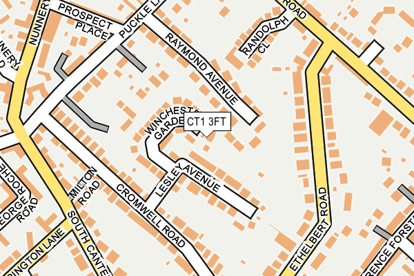
CT1 3FT is located in the Wincheap electoral ward, within the local authority district of Canterbury and the English Parliamentary constituency of Canterbury. The Sub Integrated Care Board (ICB) Location is NHS Kent and Medway ICB - 91Q and the police force is Kent. This postcode has been in use since April 2017.


GetTheData
Source: OS OpenMap – Local (Ordnance Survey)
Source: OS VectorMap District (Ordnance Survey)
Licence: Open Government Licence (requires attribution)
| Easting | 615333 |
| Northing | 156844 |
| Latitude | 51.270051 |
| Longitude | 1.085581 |
GetTheData
Source: Open Postcode Geo
Licence: Open Government Licence
| Country | England |
| Postcode District | CT1 |
➜ See where CT1 is on a map ➜ Where is Canterbury? | |
GetTheData
Source: Land Registry Price Paid Data
Licence: Open Government Licence
| Ward | Wincheap |
| Constituency | Canterbury |
GetTheData
Source: ONS Postcode Database
Licence: Open Government Licence
| Ethelbert Road (Old Dover Road) | Canterbury | 215m |
| Ethelbert Road (Old Dover Road) | Canterbury | 231m |
| John Graham Court (South Canterbury Road) | South Canterbury | 232m |
| Puckle Lane (South Canterbury Road) | South Canterbury | 249m |
| Puckle Lane (South Canterbury Road) | South Canterbury | 271m |
| Canterbury East Station | 0.8km |
| Canterbury West Station | 1.7km |
| Bekesbourne Station | 3.7km |
GetTheData
Source: NaPTAN
Licence: Open Government Licence
| Percentage of properties with Next Generation Access | 100.0% |
| Percentage of properties with Superfast Broadband | 100.0% |
| Percentage of properties with Ultrafast Broadband | 0.0% |
| Percentage of properties with Full Fibre Broadband | 0.0% |
Superfast Broadband is between 30Mbps and 300Mbps
Ultrafast Broadband is > 300Mbps
| Percentage of properties unable to receive 2Mbps | 0.0% |
| Percentage of properties unable to receive 5Mbps | 0.0% |
| Percentage of properties unable to receive 10Mbps | 0.0% |
| Percentage of properties unable to receive 30Mbps | 0.0% |
GetTheData
Source: Ofcom
Licence: Ofcom Terms of Use (requires attribution)
GetTheData
Source: ONS Postcode Database
Licence: Open Government Licence


➜ Get more ratings from the Food Standards Agency
GetTheData
Source: Food Standards Agency
Licence: FSA terms & conditions
| Last Collection | |||
|---|---|---|---|
| Location | Mon-Fri | Sat | Distance |
| South Canterbury Road | 18:00 | 12:30 | 218m |
| Ethelbert Road | 18:00 | 12:15 | 225m |
| Hospital Approach | 18:00 | 12:30 | 253m |
GetTheData
Source: Dracos
Licence: Creative Commons Attribution-ShareAlike
The below table lists the International Territorial Level (ITL) codes (formerly Nomenclature of Territorial Units for Statistics (NUTS) codes) and Local Administrative Units (LAU) codes for CT1 3FT:
| ITL 1 Code | Name |
|---|---|
| TLJ | South East (England) |
| ITL 2 Code | Name |
| TLJ4 | Kent |
| ITL 3 Code | Name |
| TLJ44 | East Kent |
| LAU 1 Code | Name |
| E07000106 | Canterbury |
GetTheData
Source: ONS Postcode Directory
Licence: Open Government Licence
The below table lists the Census Output Area (OA), Lower Layer Super Output Area (LSOA), and Middle Layer Super Output Area (MSOA) for CT1 3FT:
| Code | Name | |
|---|---|---|
| OA | E00122489 | |
| LSOA | E01024131 | Canterbury 016E |
| MSOA | E02005025 | Canterbury 016 |
GetTheData
Source: ONS Postcode Directory
Licence: Open Government Licence
| CT1 3NA | Winchester Gardens | 54m |
| CT1 3LF | Lesley Avenue | 64m |
| CT1 3JZ | Raymond Avenue | 66m |
| CT1 3JY | Raymond Avenue | 86m |
| CT1 3LD | Cromwell Road | 134m |
| CT1 3ND | Ethelbert Road | 142m |
| CT1 3AZ | Randolph Close | 165m |
| CT1 3LA | Puckle Lane | 174m |
| CT1 3LE | Cromwell Road | 177m |
| CT1 3LB | Cromwell Road | 182m |
GetTheData
Source: Open Postcode Geo; Land Registry Price Paid Data
Licence: Open Government Licence