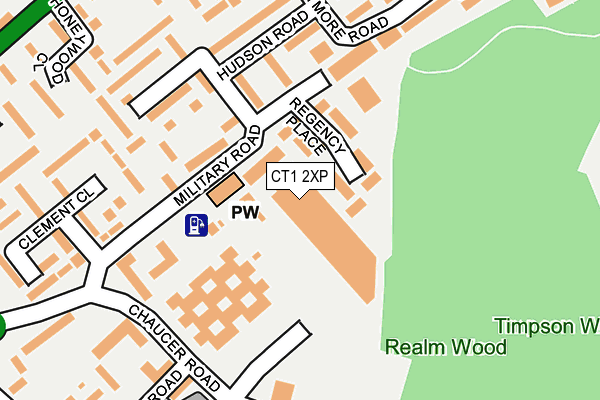
CT1 2XP is located in the Northgate electoral ward, within the local authority district of Canterbury and the English Parliamentary constituency of Canterbury. The Sub Integrated Care Board (ICB) Location is NHS Kent and Medway ICB - 91Q and the police force is Kent. This postcode has been in use since June 2002.


GetTheData
Source: OS OpenMap – Local (Ordnance Survey)
Source: OS VectorMap District (Ordnance Survey)
Licence: Open Government Licence (requires attribution)
| Easting | 615886 |
| Northing | 158470 |
| Latitude | 51.284437 |
| Longitude | 1.094448 |
GetTheData
Source: Open Postcode Geo
Licence: Open Government Licence
| Country | England |
| Postcode District | CT1 |
➜ See where CT1 is on a map ➜ Where is Canterbury? | |
GetTheData
Source: Land Registry Price Paid Data
Licence: Open Government Licence
Elevation or altitude of CT1 2XP as distance above sea level:
| Metres | Feet | |
|---|---|---|
| Elevation | 20m | 66ft |
Elevation is measured from the approximate centre of the postcode, to the nearest point on an OS contour line from OS Terrain 50, which has contour spacing of ten vertical metres.
➜ How high above sea level am I? Find the elevation of your current position using your device's GPS.
GetTheData
Source: Open Postcode Elevation
Licence: Open Government Licence
| Ward | Northgate |
| Constituency | Canterbury |
GetTheData
Source: ONS Postcode Database
Licence: Open Government Licence
| Civic Centre (Military Road) | Northgate | 121m |
| Civic Centre (Military Road) | Northgate | 143m |
| Hudson Road | Northgate | 147m |
| Law Courts (Chaucer Road) | Northgate | 225m |
| Brymore Road Terminus (Brymore Road) | Northgate | 237m |
| Canterbury West Station | 1.3km |
| Canterbury East Station | 1.7km |
| Sturry Station | 2.7km |
GetTheData
Source: NaPTAN
Licence: Open Government Licence
GetTheData
Source: ONS Postcode Database
Licence: Open Government Licence


➜ Get more ratings from the Food Standards Agency
GetTheData
Source: Food Standards Agency
Licence: FSA terms & conditions
| Last Collection | |||
|---|---|---|---|
| Location | Mon-Fri | Sat | Distance |
| Canterbury Mail Centre | 19:30 | 73m | |
| Canterbury Mail Centre | 19:30 | 13:00 | 78m |
| Glenside Avenue | 17:30 | 12:15 | 353m |
GetTheData
Source: Dracos
Licence: Creative Commons Attribution-ShareAlike
The below table lists the International Territorial Level (ITL) codes (formerly Nomenclature of Territorial Units for Statistics (NUTS) codes) and Local Administrative Units (LAU) codes for CT1 2XP:
| ITL 1 Code | Name |
|---|---|
| TLJ | South East (England) |
| ITL 2 Code | Name |
| TLJ4 | Kent |
| ITL 3 Code | Name |
| TLJ44 | East Kent |
| LAU 1 Code | Name |
| E07000106 | Canterbury |
GetTheData
Source: ONS Postcode Directory
Licence: Open Government Licence
The below table lists the Census Output Area (OA), Lower Layer Super Output Area (LSOA), and Middle Layer Super Output Area (MSOA) for CT1 2XP:
| Code | Name | |
|---|---|---|
| OA | E00122311 | |
| LSOA | E01024092 | Canterbury 014D |
| MSOA | E02005023 | Canterbury 014 |
GetTheData
Source: ONS Postcode Directory
Licence: Open Government Licence
| CT1 1YS | Regency Place | 60m |
| CT1 1JH | Military Road | 122m |
| CT1 1LL | Military Road | 142m |
| CT1 1JG | Military Road | 163m |
| CT1 1HU | Teddington Close | 164m |
| CT1 1LD | Remston Mews | 171m |
| CT1 1JF | Hudson Road | 184m |
| CT1 1LA | Hallett Walk | 192m |
| CT1 1HX | Anne Green Walk | 206m |
| CT1 1JA | Arran Mews | 207m |
GetTheData
Source: Open Postcode Geo; Land Registry Price Paid Data
Licence: Open Government Licence