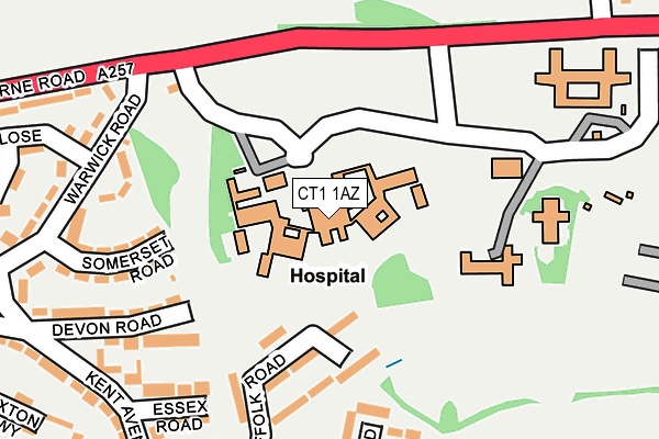
CT1 1AZ is located in the Barton electoral ward, within the local authority district of Canterbury and the English Parliamentary constituency of Canterbury. The Sub Integrated Care Board (ICB) Location is NHS Kent and Medway ICB - 91Q and the police force is Kent. This postcode has been in use since August 1993.


GetTheData
Source: OS OpenMap – Local (Ordnance Survey)
Source: OS VectorMap District (Ordnance Survey)
Licence: Open Government Licence (requires attribution)
| Easting | 616739 |
| Northing | 157662 |
| Latitude | 51.276859 |
| Longitude | 1.106171 |
GetTheData
Source: Open Postcode Geo
Licence: Open Government Licence
| Country | England |
| Postcode District | CT1 |
➜ See where CT1 is on a map ➜ Where is Canterbury? | |
GetTheData
Source: Land Registry Price Paid Data
Licence: Open Government Licence
Elevation or altitude of CT1 1AZ as distance above sea level:
| Metres | Feet | |
|---|---|---|
| Elevation | 40m | 131ft |
Elevation is measured from the approximate centre of the postcode, to the nearest point on an OS contour line from OS Terrain 50, which has contour spacing of ten vertical metres.
➜ How high above sea level am I? Find the elevation of your current position using your device's GPS.
GetTheData
Source: Open Postcode Elevation
Licence: Open Government Licence
| Ward | Barton |
| Constituency | Canterbury |
GetTheData
Source: ONS Postcode Database
Licence: Open Government Licence
| St Martin's Hospital (Littlebourne Road) | Canterbury | 182m |
| St Martin's Hospital (Littlebourne Road) | Canterbury | 199m |
| Avon Close (Warwick Road) | Spring Lane Estate | 212m |
| Avon Close (Warwick Road) | Spring Lane Estate | 221m |
| Essex Road (Kent Avenue) | Spring Lane Estate | 244m |
| Canterbury East Station | 2.1km |
| Canterbury West Station | 2.3km |
| Bekesbourne Station | 2.7km |
GetTheData
Source: NaPTAN
Licence: Open Government Licence
GetTheData
Source: ONS Postcode Database
Licence: Open Government Licence


➜ Get more ratings from the Food Standards Agency
GetTheData
Source: Food Standards Agency
Licence: FSA terms & conditions
| Last Collection | |||
|---|---|---|---|
| Location | Mon-Fri | Sat | Distance |
| Kent Avenue | 18:00 | 12:00 | 284m |
| Collard House | 18:00 | 12:00 | 408m |
| St Martins Hill Post Office | 18:00 | 12:00 | 546m |
GetTheData
Source: Dracos
Licence: Creative Commons Attribution-ShareAlike
The below table lists the International Territorial Level (ITL) codes (formerly Nomenclature of Territorial Units for Statistics (NUTS) codes) and Local Administrative Units (LAU) codes for CT1 1AZ:
| ITL 1 Code | Name |
|---|---|
| TLJ | South East (England) |
| ITL 2 Code | Name |
| TLJ4 | Kent |
| ITL 3 Code | Name |
| TLJ44 | East Kent |
| LAU 1 Code | Name |
| E07000106 | Canterbury |
GetTheData
Source: ONS Postcode Directory
Licence: Open Government Licence
The below table lists the Census Output Area (OA), Lower Layer Super Output Area (LSOA), and Middle Layer Super Output Area (MSOA) for CT1 1AZ:
| Code | Name | |
|---|---|---|
| OA | E00122082 | |
| LSOA | E01024047 | Canterbury 014A |
| MSOA | E02005023 | Canterbury 014 |
GetTheData
Source: ONS Postcode Directory
Licence: Open Government Licence
| CT1 1SA | Suffolk Road | 141m |
| CT1 1RH | Somerset Road | 204m |
| CT1 1RP | Devon Road | 207m |
| CT1 1RS | Essex Road | 208m |
| CT1 1SD | Rutland Close | 219m |
| CT1 1RZ | Sussex Avenue | 241m |
| CT1 1RG | Warwick Road | 247m |
| CT1 1SE | Sussex Avenue | 260m |
| CT1 1SR | Orchard Flats | 268m |
| CT1 1RR | Kent Avenue | 269m |
GetTheData
Source: Open Postcode Geo; Land Registry Price Paid Data
Licence: Open Government Licence