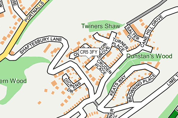
CR5 3FY is located in the Coulsdon Town electoral ward, within the London borough of Croydon and the English Parliamentary constituency of Croydon South. The Sub Integrated Care Board (ICB) Location is NHS South West London ICB - 36L and the police force is Metropolitan Police. This postcode has been in use since February 2017.


GetTheData
Source: OS OpenMap – Local (Ordnance Survey)
Source: OS VectorMap District (Ordnance Survey)
Licence: Open Government Licence (requires attribution)
| Easting | 529383 |
| Northing | 159016 |
| Latitude | 51.315550 |
| Longitude | -0.144861 |
GetTheData
Source: Open Postcode Geo
Licence: Open Government Licence
| Country | England |
| Postcode District | CR5 |
➜ See where CR5 is on a map ➜ Where is Coulsdon? | |
GetTheData
Source: Land Registry Price Paid Data
Licence: Open Government Licence
| Ward | Coulsdon Town |
| Constituency | Croydon South |
GetTheData
Source: ONS Postcode Database
Licence: Open Government Licence
7, TURNER PLACE, COULSDON, CR5 3FY 2017 30 JUN £574,995 |
13, TURNER PLACE, COULSDON, CR5 3FY 2017 22 JUN £534,995 |
2, TURNER PLACE, COULSDON, CR5 3FY 2017 28 APR £594,995 |
1, TURNER PLACE, COULSDON, CR5 3FY 2017 28 APR £589,995 |
15, TURNER PLACE, COULSDON, CR5 3FY 2017 28 APR £567,995 |
12, TURNER PLACE, COULSDON, CR5 3FY 2017 28 APR £614,995 |
GetTheData
Source: HM Land Registry Price Paid Data
Licence: Contains HM Land Registry data © Crown copyright and database right 2025. This data is licensed under the Open Government Licence v3.0.
| Coulsdon South | Coulsdon South | 435m |
| Coulsdon South | Coulsdon South | 435m |
| Coulsdon South | Coulsdon South | 438m |
| Portnalls Road | Coulsdon | 454m |
| Coniston Road | Coulsdon | 457m |
| Coulsdon South Station | 0.5km |
| Woodmansterne Station | 0.8km |
| Coulsdon Town Station | 1km |
GetTheData
Source: NaPTAN
Licence: Open Government Licence
| Percentage of properties with Next Generation Access | 100.0% |
| Percentage of properties with Superfast Broadband | 100.0% |
| Percentage of properties with Ultrafast Broadband | 100.0% |
| Percentage of properties with Full Fibre Broadband | 100.0% |
Superfast Broadband is between 30Mbps and 300Mbps
Ultrafast Broadband is > 300Mbps
| Percentage of properties unable to receive 2Mbps | 0.0% |
| Percentage of properties unable to receive 5Mbps | 0.0% |
| Percentage of properties unable to receive 10Mbps | 0.0% |
| Percentage of properties unable to receive 30Mbps | 0.0% |
GetTheData
Source: Ofcom
Licence: Ofcom Terms of Use (requires attribution)
GetTheData
Source: ONS Postcode Database
Licence: Open Government Licence


➜ Get more ratings from the Food Standards Agency
GetTheData
Source: Food Standards Agency
Licence: FSA terms & conditions
| Last Collection | |||
|---|---|---|---|
| Location | Mon-Fri | Sat | Distance |
| Brighton Road | 17:15 | 12:00 | 470m |
| Coulsdon Mspo | 18:45 | 12:00 | 560m |
| Portnalls Road(50) | 17:00 | 12:00 | 560m |
GetTheData
Source: Dracos
Licence: Creative Commons Attribution-ShareAlike
The below table lists the International Territorial Level (ITL) codes (formerly Nomenclature of Territorial Units for Statistics (NUTS) codes) and Local Administrative Units (LAU) codes for CR5 3FY:
| ITL 1 Code | Name |
|---|---|
| TLI | London |
| ITL 2 Code | Name |
| TLI6 | Outer London - South |
| ITL 3 Code | Name |
| TLI62 | Croydon |
| LAU 1 Code | Name |
| E09000008 | Croydon |
GetTheData
Source: ONS Postcode Directory
Licence: Open Government Licence
The below table lists the Census Output Area (OA), Lower Layer Super Output Area (LSOA), and Middle Layer Super Output Area (MSOA) for CR5 3FY:
| Code | Name | |
|---|---|---|
| OA | E00005096 | |
| LSOA | E01001027 | Croydon 043E |
| MSOA | E02000236 | Croydon 043 |
GetTheData
Source: ONS Postcode Directory
Licence: Open Government Licence
| CR5 3DD | Portnalls Road | 283m |
| CR5 3BS | Coniston Road | 352m |
| CR5 3DG | Sherwood Road | 354m |
| CR5 3DJ | Sherwood Road | 355m |
| CR5 3DH | Vincent Road | 390m |
| CR5 3EA | Brighton Road | 392m |
| CR5 3DA | Portnalls Rise | 395m |
| CR5 3FJ | Welcombes View | 420m |
| CR5 3DB | Portnalls Close | 426m |
| CR5 3BB | Chipstead Valley Road | 432m |
GetTheData
Source: Open Postcode Geo; Land Registry Price Paid Data
Licence: Open Government Licence