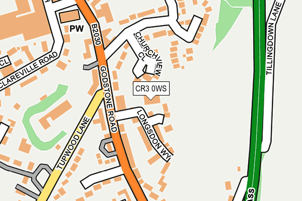
CR3 0WS is located in the Harestone electoral ward, within the local authority district of Tandridge and the English Parliamentary constituency of East Surrey. The Sub Integrated Care Board (ICB) Location is NHS Surrey Heartlands ICB - 92A and the police force is Surrey. This postcode has been in use since November 2002.


GetTheData
Source: OS OpenMap – Local (Ordnance Survey)
Source: OS VectorMap District (Ordnance Survey)
Licence: Open Government Licence (requires attribution)
| Easting | 534428 |
| Northing | 155140 |
| Latitude | 51.279551 |
| Longitude | -0.073999 |
GetTheData
Source: Open Postcode Geo
Licence: Open Government Licence
| Country | England |
| Postcode District | CR3 |
➜ See where CR3 is on a map ➜ Where is Caterham? | |
GetTheData
Source: Land Registry Price Paid Data
Licence: Open Government Licence
Elevation or altitude of CR3 0WS as distance above sea level:
| Metres | Feet | |
|---|---|---|
| Elevation | 140m | 459ft |
Elevation is measured from the approximate centre of the postcode, to the nearest point on an OS contour line from OS Terrain 50, which has contour spacing of ten vertical metres.
➜ How high above sea level am I? Find the elevation of your current position using your device's GPS.
GetTheData
Source: Open Postcode Elevation
Licence: Open Government Licence
| Ward | Harestone |
| Constituency | East Surrey |
GetTheData
Source: ONS Postcode Database
Licence: Open Government Licence
| Longsdon Way (Godstone Road) | Caterham | 80m |
| Longsdon Way (Godstone Road) | Caterham | 100m |
| White Knobs Way (Godstone Road) | Caterham | 349m |
| Caterham Railway Station (Station Avenue) | Caterham | 392m |
| Caterham Railway Station (Station Avenue) | Caterham | 399m |
| Caterham Station | 0.4km |
| Woldingham Station | 1.9km |
| Whyteleafe South Station | 2.7km |
GetTheData
Source: NaPTAN
Licence: Open Government Licence
GetTheData
Source: ONS Postcode Database
Licence: Open Government Licence


➜ Get more ratings from the Food Standards Agency
GetTheData
Source: Food Standards Agency
Licence: FSA terms & conditions
| Last Collection | |||
|---|---|---|---|
| Location | Mon-Fri | Sat | Distance |
| Caterham Delivery Office | 18:30 | 12:00 | 119m |
| Caterham Mspo | 17:15 | 12:00 | 383m |
| High Street(91 Cedarhse) | 16:45 | 12:00 | 1,038m |
GetTheData
Source: Dracos
Licence: Creative Commons Attribution-ShareAlike
The below table lists the International Territorial Level (ITL) codes (formerly Nomenclature of Territorial Units for Statistics (NUTS) codes) and Local Administrative Units (LAU) codes for CR3 0WS:
| ITL 1 Code | Name |
|---|---|
| TLJ | South East (England) |
| ITL 2 Code | Name |
| TLJ2 | Surrey, East and West Sussex |
| ITL 3 Code | Name |
| TLJ26 | East Surrey |
| LAU 1 Code | Name |
| E07000215 | Tandridge |
GetTheData
Source: ONS Postcode Directory
Licence: Open Government Licence
The below table lists the Census Output Area (OA), Lower Layer Super Output Area (LSOA), and Middle Layer Super Output Area (MSOA) for CR3 0WS:
| Code | Name | |
|---|---|---|
| OA | E00157195 | |
| LSOA | E01030830 | Tandridge 004C |
| MSOA | E02006431 | Tandridge 004 |
GetTheData
Source: ONS Postcode Directory
Licence: Open Government Licence
| CR3 6BR | Asprey Grove | 42m |
| CR3 6RZ | Godstone Road | 61m |
| CR3 6BN | Longsdon Way | 66m |
| CR3 6EZ | Churchview Close | 69m |
| CR3 6RB | Godstone Road | 118m |
| CR3 6LH | Crescent Road | 127m |
| CR3 6RF | Godstone Road | 143m |
| CR3 6DE | Deerswood Close | 145m |
| CR3 6BY | Ashwick Close | 156m |
| CR3 6RE | Godstone Road | 168m |
GetTheData
Source: Open Postcode Geo; Land Registry Price Paid Data
Licence: Open Government Licence