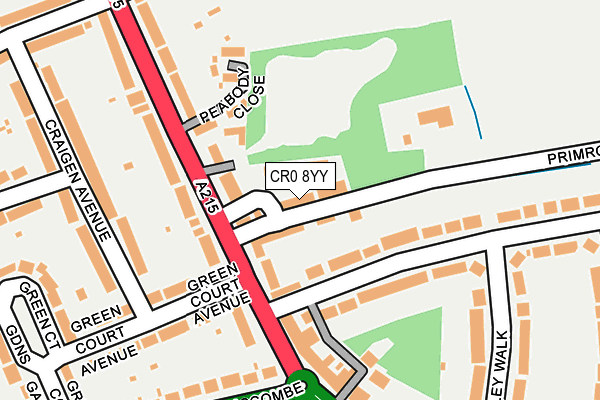
CR0 8YY is located in the Shirley North electoral ward, within the London borough of Croydon and the English Parliamentary constituency of Croydon Central. The Sub Integrated Care Board (ICB) Location is NHS South West London ICB - 36L and the police force is Metropolitan Police. This postcode has been in use since September 1991.


GetTheData
Source: OS OpenMap – Local (Ordnance Survey)
Source: OS VectorMap District (Ordnance Survey)
Licence: Open Government Licence (requires attribution)
| Easting | 535252 |
| Northing | 166199 |
| Latitude | 51.378738 |
| Longitude | -0.057971 |
GetTheData
Source: Open Postcode Geo
Licence: Open Government Licence
| Country | England |
| Postcode District | CR0 |
➜ See where CR0 is on a map ➜ Where is London? | |
GetTheData
Source: Land Registry Price Paid Data
Licence: Open Government Licence
Elevation or altitude of CR0 8YY as distance above sea level:
| Metres | Feet | |
|---|---|---|
| Elevation | 60m | 197ft |
Elevation is measured from the approximate centre of the postcode, to the nearest point on an OS contour line from OS Terrain 50, which has contour spacing of ten vertical metres.
➜ How high above sea level am I? Find the elevation of your current position using your device's GPS.
GetTheData
Source: Open Postcode Elevation
Licence: Open Government Licence
| Ward | Shirley North |
| Constituency | Croydon Central |
GetTheData
Source: ONS Postcode Database
Licence: Open Government Licence
| Shirley Ambulance Station | Shirley | 102m |
| Shirley Clinic (Shirley Road) | Addiscombe | 240m |
| Shirley Clinic (Shirley Road) | Addiscombe | 272m |
| Shirley Park Shirley Avenue (Shirley Road) | Shirley | 305m |
| Tulip Close (Primrose Lane) | Shirley | 324m |
| Woodside Tram Stop (Spring Lane) | Woodside | 1,062m |
| Addiscombe Tram Stop (Off Bingham Road) | Addiscombe | 1,068m |
| Blackhorse Lane Tram Stop (Dalmally Road) | Woodside | 1,101m |
| Arena Tram Stop (Off Albert Road) | Woodside | 1,422m |
| Sandilands Tram Stop (Addiscombe Road) | Addiscombe | 1,455m |
| Elmers End Station | 2.3km |
| Norwood Junction Station | 2.4km |
| East Croydon Station | 2.4km |
GetTheData
Source: NaPTAN
Licence: Open Government Licence
GetTheData
Source: ONS Postcode Database
Licence: Open Government Licence


➜ Get more ratings from the Food Standards Agency
GetTheData
Source: Food Standards Agency
Licence: FSA terms & conditions
| Last Collection | |||
|---|---|---|---|
| Location | Mon-Fri | Sat | Distance |
| Shirley Road (163)tso | 18:15 | 12:00 | 281m |
| Shirley Avenue(95) | 18:15 | 12:00 | 337m |
| Shirley Road(104) | 18:15 | 12:00 | 345m |
GetTheData
Source: Dracos
Licence: Creative Commons Attribution-ShareAlike
The below table lists the International Territorial Level (ITL) codes (formerly Nomenclature of Territorial Units for Statistics (NUTS) codes) and Local Administrative Units (LAU) codes for CR0 8YY:
| ITL 1 Code | Name |
|---|---|
| TLI | London |
| ITL 2 Code | Name |
| TLI6 | Outer London - South |
| ITL 3 Code | Name |
| TLI62 | Croydon |
| LAU 1 Code | Name |
| E09000008 | Croydon |
GetTheData
Source: ONS Postcode Directory
Licence: Open Government Licence
The below table lists the Census Output Area (OA), Lower Layer Super Output Area (LSOA), and Middle Layer Super Output Area (MSOA) for CR0 8YY:
| Code | Name | |
|---|---|---|
| OA | E00004937 | |
| LSOA | E01000985 | Croydon 021A |
| MSOA | E02000214 | Croydon 021 |
GetTheData
Source: ONS Postcode Directory
Licence: Open Government Licence
| CR0 8SL | Shirley Avenue | 140m |
| CR0 8SN | Shirley Avenue | 149m |
| CR0 8BN | Primrose Lane | 159m |
| CR0 8SG | Shirley Avenue | 175m |
| CR0 8SJ | Shirley Avenue | 183m |
| CR0 7LR | Shirley Road | 225m |
| CR0 7EY | Glenthorne Avenue | 250m |
| CR0 7LQ | Shirley Road | 259m |
| CR0 8SR | Valley Walk | 260m |
| CR0 8SS | Shirley Road | 272m |
GetTheData
Source: Open Postcode Geo; Land Registry Price Paid Data
Licence: Open Government Licence