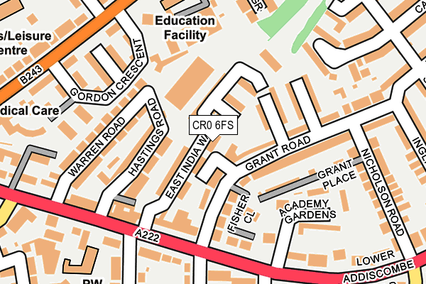
CR0 6FS is located in the Addiscombe East electoral ward, within the London borough of Croydon and the English Parliamentary constituency of Croydon Central. The Sub Integrated Care Board (ICB) Location is NHS South West London ICB - 36L and the police force is Metropolitan Police. This postcode has been in use since July 2017.


GetTheData
Source: OS OpenMap – Local (Ordnance Survey)
Source: OS VectorMap District (Ordnance Survey)
Licence: Open Government Licence (requires attribution)
| Easting | 533695 |
| Northing | 166351 |
| Latitude | 51.380473 |
| Longitude | -0.080273 |
GetTheData
Source: Open Postcode Geo
Licence: Open Government Licence
| Country | England |
| Postcode District | CR0 |
➜ See where CR0 is on a map ➜ Where is London? | |
GetTheData
Source: Land Registry Price Paid Data
Licence: Open Government Licence
| Ward | Addiscombe East |
| Constituency | Croydon Central |
GetTheData
Source: ONS Postcode Database
Licence: Open Government Licence
| Canning Road | Addiscombe | 148m |
| Canning Road | Addiscombe | 184m |
| Gordon Crescent | Addiscombe | 237m |
| Gordon Crescent | Addiscombe | 240m |
| Havelock Road (Cr0) (Lower Addiscombe Road) | Addiscombe | 255m |
| Addiscombe Tram Stop (Off Bingham Road) | Addiscombe | 497m |
| Sandilands Tram Stop (Addiscombe Road) | Addiscombe | 626m |
| Lebanon Road Tram Stop (Addiscombe Road) | Addiscombe | 672m |
| Blackhorse Lane Tram Stop (Dalmally Road) | Woodside | 828m |
| East Croydon Tram Stop (George Street) | Croydon | 1,049m |
| East Croydon Station | 1km |
| Selhurst Station | 1.4km |
| West Croydon Station | 1.6km |
GetTheData
Source: NaPTAN
Licence: Open Government Licence
| Percentage of properties with Next Generation Access | 100.0% |
| Percentage of properties with Superfast Broadband | 100.0% |
| Percentage of properties with Ultrafast Broadband | 0.0% |
| Percentage of properties with Full Fibre Broadband | 0.0% |
Superfast Broadband is between 30Mbps and 300Mbps
Ultrafast Broadband is > 300Mbps
| Percentage of properties unable to receive 2Mbps | 0.0% |
| Percentage of properties unable to receive 5Mbps | 0.0% |
| Percentage of properties unable to receive 10Mbps | 0.0% |
| Percentage of properties unable to receive 30Mbps | 0.0% |
GetTheData
Source: Ofcom
Licence: Ofcom Terms of Use (requires attribution)
GetTheData
Source: ONS Postcode Database
Licence: Open Government Licence


➜ Get more ratings from the Food Standards Agency
GetTheData
Source: Food Standards Agency
Licence: FSA terms & conditions
| Last Collection | |||
|---|---|---|---|
| Location | Mon-Fri | Sat | Distance |
| 113 Lower Addiscombe Road Tso | 17:45 | 12:00 | 168m |
| Morland Road(Classic Autos) | 17:30 | 12:00 | 230m |
| Lwr Addiscombe Road (Opp 155) | 18:00 | 12:00 | 241m |
GetTheData
Source: Dracos
Licence: Creative Commons Attribution-ShareAlike
The below table lists the International Territorial Level (ITL) codes (formerly Nomenclature of Territorial Units for Statistics (NUTS) codes) and Local Administrative Units (LAU) codes for CR0 6FS:
| ITL 1 Code | Name |
|---|---|
| TLI | London |
| ITL 2 Code | Name |
| TLI6 | Outer London - South |
| ITL 3 Code | Name |
| TLI62 | Croydon |
| LAU 1 Code | Name |
| E09000008 | Croydon |
GetTheData
Source: ONS Postcode Directory
Licence: Open Government Licence
The below table lists the Census Output Area (OA), Lower Layer Super Output Area (LSOA), and Middle Layer Super Output Area (MSOA) for CR0 6FS:
| Code | Name | |
|---|---|---|
| OA | E00004884 | |
| LSOA | E01000983 | Croydon 017D |
| MSOA | E02000210 | Croydon 017 |
GetTheData
Source: ONS Postcode Directory
Licence: Open Government Licence
| CR0 6NZ | East India Way | 31m |
| CR0 6RZ | East India Way | 32m |
| CR0 6PH | Hastings Road | 100m |
| CR0 6PN | Storrington Road | 107m |
| CR0 6QY | Fisher Close | 111m |
| CR0 6PJ | Grant Road | 118m |
| CR0 6PP | Windermere Road | 127m |
| CR0 6QL | Academy Gardens | 129m |
| CR0 6PX | Grant Place | 130m |
| CR0 6PF | Warren Road | 133m |
GetTheData
Source: Open Postcode Geo; Land Registry Price Paid Data
Licence: Open Government Licence