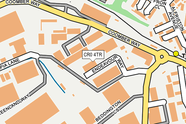
CR0 4TR is located in the Beddington electoral ward, within the London borough of Sutton and the English Parliamentary constituency of Carshalton and Wallington. The Sub Integrated Care Board (ICB) Location is NHS South West London ICB - 36L and the police force is Metropolitan Police. This postcode has been in use since August 1993.


GetTheData
Source: OS OpenMap – Local (Ordnance Survey)
Source: OS VectorMap District (Ordnance Survey)
Licence: Open Government Licence (requires attribution)
| Easting | 530010 |
| Northing | 166817 |
| Latitude | 51.385516 |
| Longitude | -0.133048 |
GetTheData
Source: Open Postcode Geo
Licence: Open Government Licence
| Country | England |
| Postcode District | CR0 |
➜ See where CR0 is on a map ➜ Where is London? | |
GetTheData
Source: Land Registry Price Paid Data
Licence: Open Government Licence
Elevation or altitude of CR0 4TR as distance above sea level:
| Metres | Feet | |
|---|---|---|
| Elevation | 40m | 131ft |
Elevation is measured from the approximate centre of the postcode, to the nearest point on an OS contour line from OS Terrain 50, which has contour spacing of ten vertical metres.
➜ How high above sea level am I? Find the elevation of your current position using your device's GPS.
GetTheData
Source: Open Postcode Elevation
Licence: Open Government Licence
| Ward | Beddington |
| Constituency | Carshalton And Wallington |
GetTheData
Source: ONS Postcode Database
Licence: Open Government Licence
| Therapia Lane Tram Stop | Broad Green | 136m |
| Therapia Lane Tram Depot | Beddington Corner | 155m |
| Therapia Lane Tram Stop | Broad Green | 180m |
| Therapia Lane Tram Depot | Beddington Corner | 205m |
| Beddington Farm Road (Ampere Way) | Broad Green | 329m |
| Therapia Lane Tram Stop (Off Alfriston Ave) | Broad Green | 279m |
| Ampere Way Tram Stop (Ampere Way) | Broad Green | 746m |
| Beddington Lane Tram Stop (Off Beddington Lane) | Beddington Corner | 758m |
| Waddon Marsh Tram Stop (Off Gurney Crescent) | Waddon | 1,406m |
| Wandle Park Tram Stop (Vicarage Road) | Waddon | 1,926m |
| Hackbridge Station | 1.7km |
| Mitcham Junction Station | 1.9km |
| West Croydon Station | 2.3km |
GetTheData
Source: NaPTAN
Licence: Open Government Licence
Estimated total energy consumption in CR0 4TR by fuel type, 2015.
| Consumption (kWh) | 72,945 |
|---|---|
| Meter count | 9 |
| Mean (kWh/meter) | 8,105 |
| Median (kWh/meter) | 1 |
GetTheData
Source: Postcode level gas estimates: 2015 (experimental)
Source: Postcode level electricity estimates: 2015 (experimental)
Licence: Open Government Licence
GetTheData
Source: ONS Postcode Database
Licence: Open Government Licence


➜ Get more ratings from the Food Standards Agency
GetTheData
Source: Food Standards Agency
Licence: FSA terms & conditions
| Last Collection | |||
|---|---|---|---|
| Location | Mon-Fri | Sat | Distance |
| The Parade (2) Tso | 17:30 | 12:00 | 497m |
| Mitcham Road(676) | 17:30 | 12:00 | 536m |
| Ringwood Avenue(36) | 17:30 | 12:00 | 541m |
GetTheData
Source: Dracos
Licence: Creative Commons Attribution-ShareAlike
The below table lists the International Territorial Level (ITL) codes (formerly Nomenclature of Territorial Units for Statistics (NUTS) codes) and Local Administrative Units (LAU) codes for CR0 4TR:
| ITL 1 Code | Name |
|---|---|
| TLI | London |
| ITL 2 Code | Name |
| TLI6 | Outer London - South |
| ITL 3 Code | Name |
| TLI63 | Merton, Kingston upon Thames and Sutton |
| LAU 1 Code | Name |
| E09000029 | Sutton |
GetTheData
Source: ONS Postcode Directory
Licence: Open Government Licence
The below table lists the Census Output Area (OA), Lower Layer Super Output Area (LSOA), and Middle Layer Super Output Area (MSOA) for CR0 4TR:
| Code | Name | |
|---|---|---|
| OA | E00020535 | |
| LSOA | E01004076 | Sutton 011A |
| MSOA | E02000850 | Sutton 011 |
GetTheData
Source: ONS Postcode Directory
Licence: Open Government Licence
| CR0 3DX | Peppermint Close | 232m |
| CR0 3GS | Rosemary Close | 234m |
| CR0 3GR | Cinnamon Close | 243m |
| CR0 3DD | Alfriston Avenue | 276m |
| CR0 3GT | Saffron Close | 290m |
| CR0 4UY | Franklin Way | 293m |
| CR0 4TN | Therapia Lane | 318m |
| CR0 4UW | Franklin Way | 323m |
| CR0 4UX | Franklin Way | 339m |
| CR0 3DG | Stonecroft Way | 341m |
GetTheData
Source: Open Postcode Geo; Land Registry Price Paid Data
Licence: Open Government Licence