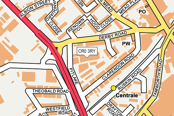
CR0 3RY is located in the Fairfield electoral ward, within the London borough of Croydon and the English Parliamentary constituency of Croydon North. The Sub Integrated Care Board (ICB) Location is NHS South West London ICB - 36L and the police force is Metropolitan Police. This postcode has been in use since March 1983.


GetTheData
Source: OS OpenMap – Local (Ordnance Survey)
Source: OS VectorMap District (Ordnance Survey)
Licence: Open Government Licence (requires attribution)
| Easting | 531892 |
| Northing | 165947 |
| Latitude | 51.377264 |
| Longitude | -0.106316 |
GetTheData
Source: Open Postcode Geo
Licence: Open Government Licence
| Country | England |
| Postcode District | CR0 |
➜ See where CR0 is on a map ➜ Where is London? | |
GetTheData
Source: Land Registry Price Paid Data
Licence: Open Government Licence
Elevation or altitude of CR0 3RY as distance above sea level:
| Metres | Feet | |
|---|---|---|
| Elevation | 50m | 164ft |
Elevation is measured from the approximate centre of the postcode, to the nearest point on an OS contour line from OS Terrain 50, which has contour spacing of ten vertical metres.
➜ How high above sea level am I? Find the elevation of your current position using your device's GPS.
GetTheData
Source: Open Postcode Elevation
Licence: Open Government Licence
| Ward | Fairfield |
| Constituency | Croydon North |
GetTheData
Source: ONS Postcode Database
Licence: Open Government Licence
| Factory Lane (Mitcham Road) | West Croydon | 203m |
| Ruskin Road (Tamworth Road) | Croydon | 212m |
| Factory Lane (Mitcham Road) | West Croydon | 229m |
| West Croydon Station (London Road) | Croydon | 233m |
| Centrale Tram Stop | Croydon | 235m |
| Reeves Corner Tram Stop (Cairo New Road) | Croydon | 221m |
| Centrale Tram Stop (Tamworth Road) | Croydon | 237m |
| West Croydon Tram Stop (Station Road) | Croydon | 375m |
| Church Street Tram Stop (Church Street) | Croydon | 419m |
| George Street Tram Stop (George Street) | Croydon | 643m |
| West Croydon Station | 0.3km |
| East Croydon Station | 1km |
| Waddon Station | 1.3km |
GetTheData
Source: NaPTAN
Licence: Open Government Licence
GetTheData
Source: ONS Postcode Database
Licence: Open Government Licence


➜ Get more ratings from the Food Standards Agency
GetTheData
Source: Food Standards Agency
Licence: FSA terms & conditions
| Last Collection | |||
|---|---|---|---|
| Location | Mon-Fri | Sat | Distance |
| West Croydon Tso | 18:15 | 12:00 | 262m |
| North End (Opp M&s) | 18:30 | 12:00 | 291m |
| London Road (99) | 18:15 | 12:00 | 379m |
GetTheData
Source: Dracos
Licence: Creative Commons Attribution-ShareAlike
The below table lists the International Territorial Level (ITL) codes (formerly Nomenclature of Territorial Units for Statistics (NUTS) codes) and Local Administrative Units (LAU) codes for CR0 3RY:
| ITL 1 Code | Name |
|---|---|
| TLI | London |
| ITL 2 Code | Name |
| TLI6 | Outer London - South |
| ITL 3 Code | Name |
| TLI62 | Croydon |
| LAU 1 Code | Name |
| E09000008 | Croydon |
GetTheData
Source: ONS Postcode Directory
Licence: Open Government Licence
The below table lists the Census Output Area (OA), Lower Layer Super Output Area (LSOA), and Middle Layer Super Output Area (MSOA) for CR0 3RY:
| Code | Name | |
|---|---|---|
| OA | E00005011 | |
| LSOA | E01001014 | Croydon 024A |
| MSOA | E02000217 | Croydon 024 |
GetTheData
Source: ONS Postcode Directory
Licence: Open Government Licence
| CR0 3SH | Ainsworth Road | 43m |
| CR0 3RA | Pitlake | 48m |
| CR0 3SG | Clarendon Road | 61m |
| CR0 3SF | Derby Road | 63m |
| CR0 3SJ | Clarendon Road | 96m |
| CR0 3SD | Renown Close | 117m |
| CR0 3SN | Hood Close | 117m |
| CR0 3SR | Hood Close | 130m |
| CR0 3SZ | Renown Close | 155m |
| CR0 1XJ | Ruskin Road | 155m |
GetTheData
Source: Open Postcode Geo; Land Registry Price Paid Data
Licence: Open Government Licence