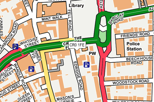
CR0 1FE is located in the Fairfield electoral ward, within the London borough of Croydon and the English Parliamentary constituency of Croydon Central. The Sub Integrated Care Board (ICB) Location is NHS South West London ICB - 36L and the police force is Metropolitan Police. This postcode has been in use since September 2011.


GetTheData
Source: OS OpenMap – Local (Ordnance Survey)
Source: OS VectorMap District (Ordnance Survey)
Licence: Open Government Licence (requires attribution)
| Easting | 532485 |
| Northing | 165211 |
| Latitude | 51.370511 |
| Longitude | -0.098074 |
GetTheData
Source: Open Postcode Geo
Licence: Open Government Licence
| Country | England |
| Postcode District | CR0 |
➜ See where CR0 is on a map ➜ Where is Croydon? | |
GetTheData
Source: Land Registry Price Paid Data
Licence: Open Government Licence
Elevation or altitude of CR0 1FE as distance above sea level:
| Metres | Feet | |
|---|---|---|
| Elevation | 50m | 164ft |
Elevation is measured from the approximate centre of the postcode, to the nearest point on an OS contour line from OS Terrain 50, which has contour spacing of ten vertical metres.
➜ How high above sea level am I? Find the elevation of your current position using your device's GPS.
GetTheData
Source: Open Postcode Elevation
Licence: Open Government Licence
| Ward | Fairfield |
| Constituency | Croydon Central |
GetTheData
Source: ONS Postcode Database
Licence: Open Government Licence
| Croydon Flyover (Croydon High Street) | Croydon | 145m |
| Croydon Flyover (Croydon High Street) | Croydon | 147m |
| Croydon Flyover (Croydon High Street) | Croydon | 147m |
| Croydon Flyover (Croydon High Street) | Croydon | 169m |
| Croydon Flyover | Croydon | 179m |
| George Street Tram Stop (George Street) | Croydon | 388m |
| Wellesley Road Tram Stop (Wellesley Road) | Croydon | 542m |
| Church Street Tram Stop (Church Street) | Croydon | 562m |
| East Croydon Tram Stop (George Street) | Croydon | 625m |
| Centrale Tram Stop (Tamworth Road) | Croydon | 711m |
| East Croydon Station | 0.7km |
| South Croydon Station | 0.9km |
| West Croydon Station | 0.9km |
GetTheData
Source: NaPTAN
Licence: Open Government Licence
GetTheData
Source: ONS Postcode Database
Licence: Open Government Licence


➜ Get more ratings from the Food Standards Agency
GetTheData
Source: Food Standards Agency
Licence: FSA terms & conditions
| Last Collection | |||
|---|---|---|---|
| Location | Mon-Fri | Sat | Distance |
| Park Lane (74) | 19:15 | 12:00 | 105m |
| Impact House | 19:15 | 115m | |
| High Street (103) | 19:15 | 12:00 | 129m |
GetTheData
Source: Dracos
Licence: Creative Commons Attribution-ShareAlike
The below table lists the International Territorial Level (ITL) codes (formerly Nomenclature of Territorial Units for Statistics (NUTS) codes) and Local Administrative Units (LAU) codes for CR0 1FE:
| ITL 1 Code | Name |
|---|---|
| TLI | London |
| ITL 2 Code | Name |
| TLI6 | Outer London - South |
| ITL 3 Code | Name |
| TLI62 | Croydon |
| LAU 1 Code | Name |
| E09000008 | Croydon |
GetTheData
Source: ONS Postcode Directory
Licence: Open Government Licence
The below table lists the Census Output Area (OA), Lower Layer Super Output Area (LSOA), and Middle Layer Super Output Area (MSOA) for CR0 1FE:
| Code | Name | |
|---|---|---|
| OA | E00005206 | |
| LSOA | E01001043 | Croydon 027B |
| MSOA | E02000220 | Croydon 027 |
GetTheData
Source: ONS Postcode Directory
Licence: Open Government Licence
| CR0 1JH | Park Lane | 93m |
| CR0 1JE | Park Lane | 114m |
| CR0 1EG | Edridge Road | 146m |
| CR0 1JG | Park Lane | 148m |
| CR0 1JW | Park Lane | 150m |
| CR0 1ND | High Street | 151m |
| CR0 1QE | High Street | 151m |
| CR0 1JF | Park Lane | 164m |
| CR0 1JX | Park Lane | 164m |
| CR0 1NE | High Street | 176m |
GetTheData
Source: Open Postcode Geo; Land Registry Price Paid Data
Licence: Open Government Licence