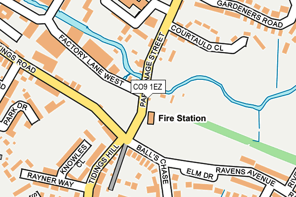
CO9 1EZ is located in the Halstead St Andrew's electoral ward, within the local authority district of Braintree and the English Parliamentary constituency of Braintree. The Sub Integrated Care Board (ICB) Location is NHS Mid and South Essex ICB - 06Q and the police force is Essex. This postcode has been in use since January 1980.


GetTheData
Source: OS OpenMap – Local (Ordnance Survey)
Source: OS VectorMap District (Ordnance Survey)
Licence: Open Government Licence (requires attribution)
| Easting | 581557 |
| Northing | 230183 |
| Latitude | 51.940523 |
| Longitude | 0.639894 |
GetTheData
Source: Open Postcode Geo
Licence: Open Government Licence
| Country | England |
| Postcode District | CO9 |
➜ See where CO9 is on a map ➜ Where is Halstead? | |
GetTheData
Source: Land Registry Price Paid Data
Licence: Open Government Licence
Elevation or altitude of CO9 1EZ as distance above sea level:
| Metres | Feet | |
|---|---|---|
| Elevation | 40m | 131ft |
Elevation is measured from the approximate centre of the postcode, to the nearest point on an OS contour line from OS Terrain 50, which has contour spacing of ten vertical metres.
➜ How high above sea level am I? Find the elevation of your current position using your device's GPS.
GetTheData
Source: Open Postcode Elevation
Licence: Open Government Licence
| Ward | Halstead St Andrew's |
| Constituency | Braintree |
GetTheData
Source: ONS Postcode Database
Licence: Open Government Licence
| High Street | Halstead | 471m |
| High Street | Halstead | 480m |
| Parker Way (Ronald Road) | Halstead | 500m |
| The Woodman (Colchester Road) | Halstead | 503m |
| The Woodman (Colchester Road) | Halstead | 508m |
GetTheData
Source: NaPTAN
Licence: Open Government Licence
GetTheData
Source: ONS Postcode Database
Licence: Open Government Licence


➜ Get more ratings from the Food Standards Agency
GetTheData
Source: Food Standards Agency
Licence: FSA terms & conditions
| Last Collection | |||
|---|---|---|---|
| Location | Mon-Fri | Sat | Distance |
| Elm Drive | 17:00 | 11:45 | 153m |
| Neale Road | 17:15 | 12:15 | 302m |
| Mitchell Avenue | 17:00 | 12:00 | 426m |
GetTheData
Source: Dracos
Licence: Creative Commons Attribution-ShareAlike
| Risk of CO9 1EZ flooding from rivers and sea | Low |
| ➜ CO9 1EZ flood map | |
GetTheData
Source: Open Flood Risk by Postcode
Licence: Open Government Licence
The below table lists the International Territorial Level (ITL) codes (formerly Nomenclature of Territorial Units for Statistics (NUTS) codes) and Local Administrative Units (LAU) codes for CO9 1EZ:
| ITL 1 Code | Name |
|---|---|
| TLH | East |
| ITL 2 Code | Name |
| TLH3 | Essex |
| ITL 3 Code | Name |
| TLH34 | Essex Haven Gateway |
| LAU 1 Code | Name |
| E07000067 | Braintree |
GetTheData
Source: ONS Postcode Directory
Licence: Open Government Licence
The below table lists the Census Output Area (OA), Lower Layer Super Output Area (LSOA), and Middle Layer Super Output Area (MSOA) for CO9 1EZ:
| Code | Name | |
|---|---|---|
| OA | E00108643 | |
| LSOA | E01021389 | Braintree 006A |
| MSOA | E02004451 | Braintree 006 |
GetTheData
Source: ONS Postcode Directory
Licence: Open Government Licence
| CO9 2JR | Parsonage Street | 108m |
| CO9 1NX | Balls Chase | 122m |
| CO9 1HA | Kings Road | 134m |
| CO9 2GY | Parsonage Street | 135m |
| CO9 1BY | Fairfield Way | 177m |
| CO9 1BZ | Knowles Close | 188m |
| CO9 1BW | Tidings Hill | 189m |
| CO9 2JS | Courtauld Close | 192m |
| CO9 1NU | Elm Drive | 210m |
| CO9 2JT | Parsonage Street | 234m |
GetTheData
Source: Open Postcode Geo; Land Registry Price Paid Data
Licence: Open Government Licence