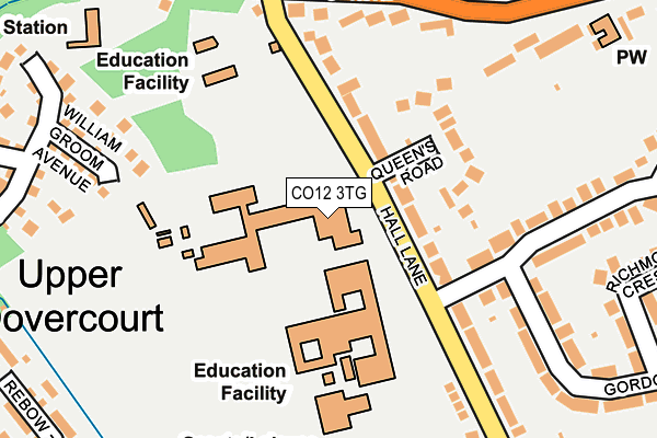
CO12 3TG lies on Hall Lane in Harwich. CO12 3TG is located in the Dovercourt All Saints electoral ward, within the local authority district of Tendring and the English Parliamentary constituency of Harwich and North Essex. The Sub Integrated Care Board (ICB) Location is NHS Suffolk and North East Essex ICB - 06T and the police force is Essex. This postcode has been in use since January 1980.


GetTheData
Source: OS OpenMap – Local (Ordnance Survey)
Source: OS VectorMap District (Ordnance Survey)
Licence: Open Government Licence (requires attribution)
| Easting | 624349 |
| Northing | 230704 |
| Latitude | 51.929609 |
| Longitude | 1.261788 |
GetTheData
Source: Open Postcode Geo
Licence: Open Government Licence
| Street | Hall Lane |
| Town/City | Harwich |
| Country | England |
| Postcode District | CO12 |
➜ See where CO12 is on a map ➜ Where is Harwich? | |
GetTheData
Source: Land Registry Price Paid Data
Licence: Open Government Licence
Elevation or altitude of CO12 3TG as distance above sea level:
| Metres | Feet | |
|---|---|---|
| Elevation | 10m | 33ft |
Elevation is measured from the approximate centre of the postcode, to the nearest point on an OS contour line from OS Terrain 50, which has contour spacing of ten vertical metres.
➜ How high above sea level am I? Find the elevation of your current position using your device's GPS.
GetTheData
Source: Open Postcode Elevation
Licence: Open Government Licence
| Ward | Dovercourt All Saints |
| Constituency | Harwich And North Essex |
GetTheData
Source: ONS Postcode Database
Licence: Open Government Licence
CARETAKERS HOUSE, THE HARWICH SCHOOL, HALL LANE, HARWICH, CO12 3TG 2008 4 AUG £180,000 |
GetTheData
Source: HM Land Registry Price Paid Data
Licence: Contains HM Land Registry data © Crown copyright and database right 2025. This data is licensed under the Open Government Licence v3.0.
| Harwich School (Hall Lane) | Upper Dovercourt | 54m |
| Harwich School (Hall Lane) | Upper Dovercourt | 125m |
| Gordon Road (Hall Lane) | Upper Dovercourt | 144m |
| Water Tower (Fronk's Road) | Upper Dovercourt | 215m |
| Water Tower (Fronk's Road) | Upper Dovercourt | 234m |
| Dovercourt Station | 1.6km |
| Harwich International Station | 2km |
| Harwich Town Station | 2.4km |
GetTheData
Source: NaPTAN
Licence: Open Government Licence
GetTheData
Source: ONS Postcode Database
Licence: Open Government Licence


➜ Get more ratings from the Food Standards Agency
GetTheData
Source: Food Standards Agency
Licence: FSA terms & conditions
| Last Collection | |||
|---|---|---|---|
| Location | Mon-Fri | Sat | Distance |
| Thelanes Fronks Road | 17:30 | 11:30 | 237m |
| Hall Lane | 17:30 | 11:30 | 263m |
| Upper Dovercourt Post Office | 17:15 | 11:30 | 540m |
GetTheData
Source: Dracos
Licence: Creative Commons Attribution-ShareAlike
The below table lists the International Territorial Level (ITL) codes (formerly Nomenclature of Territorial Units for Statistics (NUTS) codes) and Local Administrative Units (LAU) codes for CO12 3TG:
| ITL 1 Code | Name |
|---|---|
| TLH | East |
| ITL 2 Code | Name |
| TLH3 | Essex |
| ITL 3 Code | Name |
| TLH34 | Essex Haven Gateway |
| LAU 1 Code | Name |
| E07000076 | Tendring |
GetTheData
Source: ONS Postcode Directory
Licence: Open Government Licence
The below table lists the Census Output Area (OA), Lower Layer Super Output Area (LSOA), and Middle Layer Super Output Area (MSOA) for CO12 3TG:
| Code | Name | |
|---|---|---|
| OA | E00111781 | |
| LSOA | E01022006 | Tendring 002C |
| MSOA | E02004574 | Tendring 002 |
GetTheData
Source: ONS Postcode Directory
Licence: Open Government Licence
| CO12 3TE | Hall Lane | 80m |
| CO12 3TH | Queens Road | 136m |
| CO12 3TJ | Gordon Road | 145m |
| CO12 4EE | Fronks Road | 188m |
| CO12 4XU | William Groom Avenue | 220m |
| CO12 3TD | Hall Lane | 220m |
| CO12 4XT | Anson Close | 250m |
| CO12 3TR | Low Road | 262m |
| CO12 3TL | Gordon Road | 278m |
| CO12 4XS | Allfields | 284m |
GetTheData
Source: Open Postcode Geo; Land Registry Price Paid Data
Licence: Open Government Licence