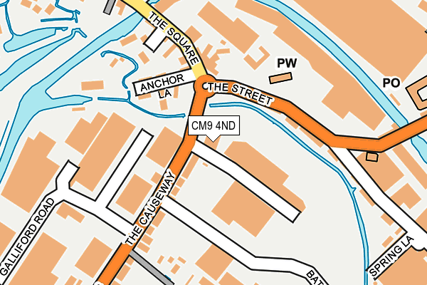
CM9 4ND is located in the Maldon North electoral ward, within the local authority district of Maldon and the English Parliamentary constituency of Maldon. The Sub Integrated Care Board (ICB) Location is NHS Mid and South Essex ICB - 06Q and the police force is Essex. This postcode has been in use since July 1995.


GetTheData
Source: OS OpenMap – Local (Ordnance Survey)
Source: OS VectorMap District (Ordnance Survey)
Licence: Open Government Licence (requires attribution)
| Easting | 585475 |
| Northing | 207992 |
| Latitude | 51.739934 |
| Longitude | 0.684937 |
GetTheData
Source: Open Postcode Geo
Licence: Open Government Licence
| Country | England |
| Postcode District | CM9 |
➜ See where CM9 is on a map ➜ Where is Maldon? | |
GetTheData
Source: Land Registry Price Paid Data
Licence: Open Government Licence
Elevation or altitude of CM9 4ND as distance above sea level:
| Metres | Feet | |
|---|---|---|
| Elevation | 10m | 33ft |
Elevation is measured from the approximate centre of the postcode, to the nearest point on an OS contour line from OS Terrain 50, which has contour spacing of ten vertical metres.
➜ How high above sea level am I? Find the elevation of your current position using your device's GPS.
GetTheData
Source: Open Postcode Elevation
Licence: Open Government Licence
| Ward | Maldon North |
| Constituency | Maldon |
GetTheData
Source: ONS Postcode Database
Licence: Open Government Licence
| Bates Road (The Causeway) | Maldon | 38m |
| Church (Heybridge Street) | Heybridge | 120m |
| Church (Heybridge Street) | Heybridge | 128m |
| The Benbridge Hotel (The Square) | Heybridge | 151m |
| The Benbridge Hotel (Square The) | Heybridge | 155m |
GetTheData
Source: NaPTAN
Licence: Open Government Licence
GetTheData
Source: ONS Postcode Database
Licence: Open Government Licence


➜ Get more ratings from the Food Standards Agency
GetTheData
Source: Food Standards Agency
Licence: FSA terms & conditions
| Last Collection | |||
|---|---|---|---|
| Location | Mon-Fri | Sat | Distance |
| The Causeway | 17:30 | 11:00 | 119m |
| Fullbridge | 17:30 | 11:30 | 784m |
| Wantz Corner | 17:30 | 11:30 | 1,055m |
GetTheData
Source: Dracos
Licence: Creative Commons Attribution-ShareAlike
| Risk of CM9 4ND flooding from rivers and sea | Low |
| ➜ CM9 4ND flood map | |
GetTheData
Source: Open Flood Risk by Postcode
Licence: Open Government Licence
The below table lists the International Territorial Level (ITL) codes (formerly Nomenclature of Territorial Units for Statistics (NUTS) codes) and Local Administrative Units (LAU) codes for CM9 4ND:
| ITL 1 Code | Name |
|---|---|
| TLH | East |
| ITL 2 Code | Name |
| TLH3 | Essex |
| ITL 3 Code | Name |
| TLH36 | Heart of Essex |
| LAU 1 Code | Name |
| E07000074 | Maldon |
GetTheData
Source: ONS Postcode Directory
Licence: Open Government Licence
The below table lists the Census Output Area (OA), Lower Layer Super Output Area (LSOA), and Middle Layer Super Output Area (MSOA) for CM9 4ND:
| Code | Name | |
|---|---|---|
| OA | E00111203 | |
| LSOA | E01021890 | Maldon 004B |
| MSOA | E02004558 | Maldon 004 |
GetTheData
Source: ONS Postcode Directory
Licence: Open Government Licence
| CM9 4XL | Heybridge House Industrial Estate | 89m |
| CM9 4LL | The Causeway | 90m |
| CM9 4LS | Anchor Lane | 114m |
| CM9 4NB | The Street | 129m |
| CM9 4LT | The Square | 138m |
| CM9 4LU | Bridge Terrace | 145m |
| CM9 4LN | Benbridge Close | 175m |
| CM9 4XD | Galliford Road Industrial Estate | 187m |
| CM9 4XB | The Street Industrial Estate | 192m |
| CM9 4TD | Chelmer Lane | 229m |
GetTheData
Source: Open Postcode Geo; Land Registry Price Paid Data
Licence: Open Government Licence