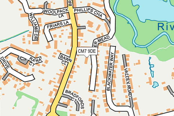
CM7 9DE lies on The Courtyard in Braintree. CM7 9DE is located in the Bocking Blackwater electoral ward, within the local authority district of Braintree and the English Parliamentary constituency of Braintree. The Sub Integrated Care Board (ICB) Location is NHS Mid and South Essex ICB - 06Q and the police force is Essex. This postcode has been in use since June 1999.


GetTheData
Source: OS OpenMap – Local (Ordnance Survey)
Source: OS VectorMap District (Ordnance Survey)
Licence: Open Government Licence (requires attribution)
| Easting | 576093 |
| Northing | 223854 |
| Latitude | 51.885432 |
| Longitude | 0.557257 |
GetTheData
Source: Open Postcode Geo
Licence: Open Government Licence
| Street | The Courtyard |
| Town/City | Braintree |
| Country | England |
| Postcode District | CM7 |
➜ See where CM7 is on a map ➜ Where is Braintree? | |
GetTheData
Source: Land Registry Price Paid Data
Licence: Open Government Licence
Elevation or altitude of CM7 9DE as distance above sea level:
| Metres | Feet | |
|---|---|---|
| Elevation | 50m | 164ft |
Elevation is measured from the approximate centre of the postcode, to the nearest point on an OS contour line from OS Terrain 50, which has contour spacing of ten vertical metres.
➜ How high above sea level am I? Find the elevation of your current position using your device's GPS.
GetTheData
Source: Open Postcode Elevation
Licence: Open Government Licence
| Ward | Bocking Blackwater |
| Constituency | Braintree |
GetTheData
Source: ONS Postcode Database
Licence: Open Government Licence
2023 8 AUG £420,000 |
4, THE COURTYARD, BRAINTREE, CM7 9DE 2017 24 FEB £300,000 |
1999 31 AUG £151,000 |
4, THE COURTYARD, BRAINTREE, CM7 9DE 1999 20 AUG £147,500 |
1, THE COURTYARD, BRAINTREE, CM7 9DE 1999 30 JUL £161,500 |
GetTheData
Source: HM Land Registry Price Paid Data
Licence: Contains HM Land Registry data © Crown copyright and database right 2025. This data is licensed under the Open Government Licence v3.0.
| Old Court Hotel (Bradford Street) | Bocking | 80m |
| Old Court Hotel (Bradford Street) | Bocking | 128m |
| Julien Court Road (Courtauld Road) | Braintree | 294m |
| Julien Court Road (Courtauld Road) | Braintree | 354m |
| Six Bells (Broad Road) | Bocking | 390m |
| Braintree Station | 1.1km |
| Braintree Freeport Station | 1.9km |
| Cressing Station | 3.9km |
GetTheData
Source: NaPTAN
Licence: Open Government Licence
| Percentage of properties with Next Generation Access | 100.0% |
| Percentage of properties with Superfast Broadband | 100.0% |
| Percentage of properties with Ultrafast Broadband | 0.0% |
| Percentage of properties with Full Fibre Broadband | 0.0% |
Superfast Broadband is between 30Mbps and 300Mbps
Ultrafast Broadband is > 300Mbps
| Percentage of properties unable to receive 2Mbps | 0.0% |
| Percentage of properties unable to receive 5Mbps | 0.0% |
| Percentage of properties unable to receive 10Mbps | 0.0% |
| Percentage of properties unable to receive 30Mbps | 0.0% |
GetTheData
Source: Ofcom
Licence: Ofcom Terms of Use (requires attribution)
GetTheData
Source: ONS Postcode Database
Licence: Open Government Licence


➜ Get more ratings from the Food Standards Agency
GetTheData
Source: Food Standards Agency
Licence: FSA terms & conditions
| Last Collection | |||
|---|---|---|---|
| Location | Mon-Fri | Sat | Distance |
| Little Bradfords | 17:00 | 08:30 | 180m |
| Coldnailhurst Avenue | 17:15 | 09:15 | 620m |
| Panfield Lane | 17:30 | 09:00 | 745m |
GetTheData
Source: Dracos
Licence: Creative Commons Attribution-ShareAlike
The below table lists the International Territorial Level (ITL) codes (formerly Nomenclature of Territorial Units for Statistics (NUTS) codes) and Local Administrative Units (LAU) codes for CM7 9DE:
| ITL 1 Code | Name |
|---|---|
| TLH | East |
| ITL 2 Code | Name |
| TLH3 | Essex |
| ITL 3 Code | Name |
| TLH34 | Essex Haven Gateway |
| LAU 1 Code | Name |
| E07000067 | Braintree |
GetTheData
Source: ONS Postcode Directory
Licence: Open Government Licence
The below table lists the Census Output Area (OA), Lower Layer Super Output Area (LSOA), and Middle Layer Super Output Area (MSOA) for CM7 9DE:
| Code | Name | |
|---|---|---|
| OA | E00108461 | |
| LSOA | E01021350 | Braintree 009A |
| MSOA | E02004454 | Braintree 009 |
GetTheData
Source: ONS Postcode Directory
Licence: Open Government Licence
| CM7 9BX | Blackwater Way | 69m |
| CM7 9AT | Bradford Street | 89m |
| CM7 9AY | Bawn Close | 99m |
| CM7 9AS | Bradford Street | 125m |
| CM7 9AZ | The Retreat | 132m |
| CM7 9FU | Kingswood Court | 136m |
| CM7 2XJ | Rana Court | 144m |
| CM7 9YH | Bradfords Court | 148m |
| CM7 9BH | Phillips Chase | 149m |
| CM7 9BL | Friars Lane | 154m |
GetTheData
Source: Open Postcode Geo; Land Registry Price Paid Data
Licence: Open Government Licence