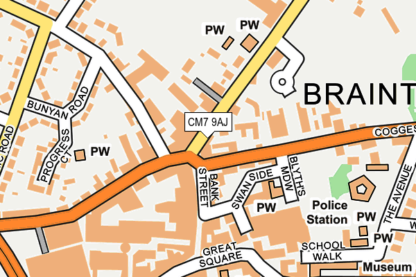
CM7 9AJ is located in the Bocking Blackwater electoral ward, within the local authority district of Braintree and the English Parliamentary constituency of Braintree. The Sub Integrated Care Board (ICB) Location is NHS Mid and South Essex ICB - 06Q and the police force is Essex. This postcode has been in use since July 1995.


GetTheData
Source: OS OpenMap – Local (Ordnance Survey)
Source: OS VectorMap District (Ordnance Survey)
Licence: Open Government Licence (requires attribution)
| Easting | 575705 |
| Northing | 223248 |
| Latitude | 51.880111 |
| Longitude | 0.551317 |
GetTheData
Source: Open Postcode Geo
Licence: Open Government Licence
| Country | England |
| Postcode District | CM7 |
➜ See where CM7 is on a map ➜ Where is Braintree? | |
GetTheData
Source: Land Registry Price Paid Data
Licence: Open Government Licence
Elevation or altitude of CM7 9AJ as distance above sea level:
| Metres | Feet | |
|---|---|---|
| Elevation | 70m | 230ft |
Elevation is measured from the approximate centre of the postcode, to the nearest point on an OS contour line from OS Terrain 50, which has contour spacing of ten vertical metres.
➜ How high above sea level am I? Find the elevation of your current position using your device's GPS.
GetTheData
Source: Open Postcode Elevation
Licence: Open Government Licence
| Ward | Bocking Blackwater |
| Constituency | Braintree |
GetTheData
Source: ONS Postcode Database
Licence: Open Government Licence
| Blyth's Meadow (Coggeshall Road) | Braintree Town Centre | 107m |
| Danlecs (Rayne Road) | Braintree Town Centre | 107m |
| High Street | Braintree Town Centre | 217m |
| Aetheric Road | Braintree | 284m |
| Victoria Street (Fairfield Road) | Braintree Town Centre | 299m |
| Braintree Station | 0.6km |
| Braintree Freeport Station | 1.7km |
| Cressing Station | 3.6km |
GetTheData
Source: NaPTAN
Licence: Open Government Licence
GetTheData
Source: ONS Postcode Database
Licence: Open Government Licence


➜ Get more ratings from the Food Standards Agency
GetTheData
Source: Food Standards Agency
Licence: FSA terms & conditions
| Last Collection | |||
|---|---|---|---|
| Location | Mon-Fri | Sat | Distance |
| Co-op | 17:30 | 11:15 | 209m |
| Panfield Lane | 17:30 | 09:00 | 273m |
| Fairfield Road | 17:30 | 12:30 | 294m |
GetTheData
Source: Dracos
Licence: Creative Commons Attribution-ShareAlike
The below table lists the International Territorial Level (ITL) codes (formerly Nomenclature of Territorial Units for Statistics (NUTS) codes) and Local Administrative Units (LAU) codes for CM7 9AJ:
| ITL 1 Code | Name |
|---|---|
| TLH | East |
| ITL 2 Code | Name |
| TLH3 | Essex |
| ITL 3 Code | Name |
| TLH34 | Essex Haven Gateway |
| LAU 1 Code | Name |
| E07000067 | Braintree |
GetTheData
Source: ONS Postcode Directory
Licence: Open Government Licence
The below table lists the Census Output Area (OA), Lower Layer Super Output Area (LSOA), and Middle Layer Super Output Area (MSOA) for CM7 9AJ:
| Code | Name | |
|---|---|---|
| OA | E00108447 | |
| LSOA | E01021350 | Braintree 009A |
| MSOA | E02004454 | Braintree 009 |
GetTheData
Source: ONS Postcode Directory
Licence: Open Government Licence
| CM7 9UT | St Lawrence Court | 61m |
| CM7 1UG | Bank Street | 90m |
| CM7 9AE | Bocking End | 96m |
| CM7 9BY | Coggeshall Road | 101m |
| CM7 1UW | Swan Side | 102m |
| CM7 1UX | Swan Side | 103m |
| CM7 2QA | Rayne Road | 110m |
| CM7 2QH | Rayne Road | 111m |
| CM7 1UT | Little Square | 124m |
| CM7 2AU | Chinnerys Court | 141m |
GetTheData
Source: Open Postcode Geo; Land Registry Price Paid Data
Licence: Open Government Licence