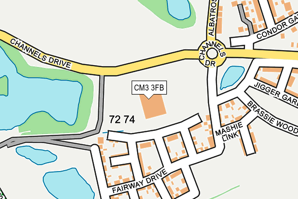
CM3 3FB is located in the Broomfield and The Walthams electoral ward, within the local authority district of Chelmsford and the English Parliamentary constituency of Saffron Walden. The Sub Integrated Care Board (ICB) Location is NHS Mid and South Essex ICB - 06Q and the police force is Essex. This postcode has been in use since June 2002.


GetTheData
Source: OS OpenMap – Local (Ordnance Survey)
Source: OS VectorMap District (Ordnance Survey)
Licence: Open Government Licence (requires attribution)
| Easting | 572055 |
| Northing | 210707 |
| Latitude | 51.768600 |
| Longitude | 0.492116 |
GetTheData
Source: Open Postcode Geo
Licence: Open Government Licence
| Country | England |
| Postcode District | CM3 |
➜ See where CM3 is on a map ➜ Where is Chelmsford? | |
GetTheData
Source: Land Registry Price Paid Data
Licence: Open Government Licence
Elevation or altitude of CM3 3FB as distance above sea level:
| Metres | Feet | |
|---|---|---|
| Elevation | 50m | 164ft |
Elevation is measured from the approximate centre of the postcode, to the nearest point on an OS contour line from OS Terrain 50, which has contour spacing of ten vertical metres.
➜ How high above sea level am I? Find the elevation of your current position using your device's GPS.
GetTheData
Source: Open Postcode Elevation
Licence: Open Government Licence
| Ward | Broomfield And The Walthams |
| Constituency | Saffron Walden |
GetTheData
Source: ONS Postcode Database
Licence: Open Government Licence
| Blacksmith Close (Pump Lane) | North Springfield | 1,179m |
| Saddle Rise (Paddock Drive) | North Springfield | 1,180m |
| Croft Court (Paddock Drive) | North Springfield | 1,198m |
| Harness Close (Paddock Drive) | North Springfield | 1,288m |
| Butlers Farm (Main Road) | Broomfield | 1,311m |
| Chelmsford Station | 3.9km |
GetTheData
Source: NaPTAN
Licence: Open Government Licence
GetTheData
Source: ONS Postcode Database
Licence: Open Government Licence


➜ Get more ratings from the Food Standards Agency
GetTheData
Source: Food Standards Agency
Licence: FSA terms & conditions
| Last Collection | |||
|---|---|---|---|
| Location | Mon-Fri | Sat | Distance |
| Mill Lane | 17:10 | 13:00 | 1,126m |
| Church Green | 17:15 | 13:00 | 1,262m |
| Church Avenue | 17:00 | 13:00 | 1,571m |
GetTheData
Source: Dracos
Licence: Creative Commons Attribution-ShareAlike
The below table lists the International Territorial Level (ITL) codes (formerly Nomenclature of Territorial Units for Statistics (NUTS) codes) and Local Administrative Units (LAU) codes for CM3 3FB:
| ITL 1 Code | Name |
|---|---|
| TLH | East |
| ITL 2 Code | Name |
| TLH3 | Essex |
| ITL 3 Code | Name |
| TLH36 | Heart of Essex |
| LAU 1 Code | Name |
| E07000070 | Chelmsford |
GetTheData
Source: ONS Postcode Directory
Licence: Open Government Licence
The below table lists the Census Output Area (OA), Lower Layer Super Output Area (LSOA), and Middle Layer Super Output Area (MSOA) for CM3 3FB:
| Code | Name | |
|---|---|---|
| OA | E00109424 | |
| LSOA | E01021541 | Chelmsford 001D |
| MSOA | E02004485 | Chelmsford 001 |
GetTheData
Source: ONS Postcode Directory
Licence: Open Government Licence
| CM3 3PY | Belsteads Farm Lane | 232m |
| CM3 3FR | Jigger Gardens | 256m |
| CM3 3FP | Brassie Wood | 330m |
| CM1 7TQ | Mill Lane | 444m |
| CM3 3PT | Belsteads Farm Lane | 558m |
| CM3 3PP | Back Lane | 734m |
| CM1 7BL | Cricketers Close | 1070m |
| CM1 6SZ | Anvil Way | 1074m |
| CM1 6SY | Blacksmith Close | 1081m |
| CM1 6SX | Saddle Rise | 1083m |
GetTheData
Source: Open Postcode Geo; Land Registry Price Paid Data
Licence: Open Government Licence