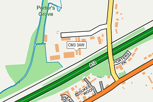
CM3 3AW is located in the Boreham and The Leighs electoral ward, within the local authority district of Chelmsford and the English Parliamentary constituency of Saffron Walden. The Sub Integrated Care Board (ICB) Location is NHS Mid and South Essex ICB - 06Q and the police force is Essex. This postcode has been in use since January 1980.


GetTheData
Source: OS OpenMap – Local (Ordnance Survey)
Source: OS VectorMap District (Ordnance Survey)
Licence: Open Government Licence (requires attribution)
| Easting | 575981 |
| Northing | 210623 |
| Latitude | 51.766633 |
| Longitude | 0.548937 |
GetTheData
Source: Open Postcode Geo
Licence: Open Government Licence
| Country | England |
| Postcode District | CM3 |
➜ See where CM3 is on a map ➜ Where is Boreham? | |
GetTheData
Source: Land Registry Price Paid Data
Licence: Open Government Licence
Elevation or altitude of CM3 3AW as distance above sea level:
| Metres | Feet | |
|---|---|---|
| Elevation | 40m | 131ft |
Elevation is measured from the approximate centre of the postcode, to the nearest point on an OS contour line from OS Terrain 50, which has contour spacing of ten vertical metres.
➜ How high above sea level am I? Find the elevation of your current position using your device's GPS.
GetTheData
Source: Open Postcode Elevation
Licence: Open Government Licence
| Ward | Boreham And The Leighs |
| Constituency | Saffron Walden |
GetTheData
Source: ONS Postcode Database
Licence: Open Government Licence
| The Cock (Main Road) | Boreham | 198m |
| The Cock (Main Road) | Boreham | 227m |
| Recreation Ground (Main Road) | Boreham | 376m |
| Recreation Ground (Main Road) | Boreham | 416m |
| Plantation Road | Boreham | 551m |
| Hatfield Peverel Station | 3.3km |
GetTheData
Source: NaPTAN
Licence: Open Government Licence
| Median download speed | 6.3Mbps |
| Average download speed | 26.4Mbps |
| Maximum download speed | 80.00Mbps |
| Median upload speed | 0.9Mbps |
| Average upload speed | 6.4Mbps |
| Maximum upload speed | 19.61Mbps |
GetTheData
Source: Ofcom
Licence: Ofcom Terms of Use (requires attribution)
GetTheData
Source: ONS Postcode Database
Licence: Open Government Licence


➜ Get more ratings from the Food Standards Agency
GetTheData
Source: Food Standards Agency
Licence: FSA terms & conditions
| Last Collection | |||
|---|---|---|---|
| Location | Mon-Fri | Sat | Distance |
| Essex Distribution Centre | 3,721m | ||
| Chelmer Village Way | 17:40 | 12:00 | 3,797m |
| Church Green | 17:15 | 13:00 | 4,091m |
GetTheData
Source: Dracos
Licence: Creative Commons Attribution-ShareAlike
The below table lists the International Territorial Level (ITL) codes (formerly Nomenclature of Territorial Units for Statistics (NUTS) codes) and Local Administrative Units (LAU) codes for CM3 3AW:
| ITL 1 Code | Name |
|---|---|
| TLH | East |
| ITL 2 Code | Name |
| TLH3 | Essex |
| ITL 3 Code | Name |
| TLH36 | Heart of Essex |
| LAU 1 Code | Name |
| E07000070 | Chelmsford |
GetTheData
Source: ONS Postcode Directory
Licence: Open Government Licence
The below table lists the Census Output Area (OA), Lower Layer Super Output Area (LSOA), and Middle Layer Super Output Area (MSOA) for CM3 3AW:
| Code | Name | |
|---|---|---|
| OA | E00109408 | |
| LSOA | E01021537 | Chelmsford 005B |
| MSOA | E02004489 | Chelmsford 005 |
GetTheData
Source: ONS Postcode Directory
Licence: Open Government Licence
| CM3 3BQ | Waltham Road | 161m |
| CM3 3AA | Main Road | 182m |
| CM3 3AS | Chantry Villas | 190m |
| CM3 3AE | Shearers Way | 195m |
| CM3 3BH | Porters Park | 209m |
| CM3 3AG | Main Road | 223m |
| CM3 3JZ | Main Road | 274m |
| CM3 3JL | Boleyn Way | 299m |
| CM3 3JD | Main Road | 318m |
| CM3 3AD | Main Road | 409m |
GetTheData
Source: Open Postcode Geo; Land Registry Price Paid Data
Licence: Open Government Licence