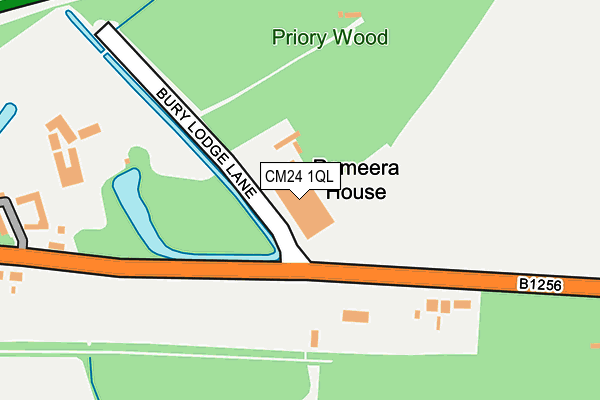
CM24 1QL is located in the Takeley electoral ward, within the local authority district of Uttlesford and the English Parliamentary constituency of Saffron Walden. The Sub Integrated Care Board (ICB) Location is NHS Hertfordshire and West Essex ICB - 07H and the police force is Essex. This postcode has been in use since December 2001.


GetTheData
Source: OS OpenMap – Local (Ordnance Survey)
Source: OS VectorMap District (Ordnance Survey)
Licence: Open Government Licence (requires attribution)
| Easting | 553325 |
| Northing | 221416 |
| Latitude | 51.870250 |
| Longitude | 0.225641 |
GetTheData
Source: Open Postcode Geo
Licence: Open Government Licence
| Country | England |
| Postcode District | CM24 |
➜ See where CM24 is on a map | |
GetTheData
Source: Land Registry Price Paid Data
Licence: Open Government Licence
Elevation or altitude of CM24 1QL as distance above sea level:
| Metres | Feet | |
|---|---|---|
| Elevation | 100m | 328ft |
Elevation is measured from the approximate centre of the postcode, to the nearest point on an OS contour line from OS Terrain 50, which has contour spacing of ten vertical metres.
➜ How high above sea level am I? Find the elevation of your current position using your device's GPS.
GetTheData
Source: Open Postcode Elevation
Licence: Open Government Licence
| Ward | Takeley |
| Constituency | Saffron Walden |
GetTheData
Source: ONS Postcode Database
Licence: Open Government Licence
| Bury Lodge Lane (Dunmow Road) | Takeley Street | 101m |
| Bury Lodge Lane (Dunmow Road) | Takeley Street | 168m |
| Thremhall Priory (Dunmow Road) | Birchanger | 294m |
| Thremhall Priory (Dunmow Road) | Birchanger | 348m |
| The Old Mill (Dunmow Road) | Takeley Street | 638m |
| Stansted Airport Station | 3.2km |
| Stansted Mountfitchet Station | 3.9km |
| Bishops Stortford Station | 4.2km |
GetTheData
Source: NaPTAN
Licence: Open Government Licence
GetTheData
Source: ONS Postcode Database
Licence: Open Government Licence

➜ Get more ratings from the Food Standards Agency
GetTheData
Source: Food Standards Agency
Licence: FSA terms & conditions
| Last Collection | |||
|---|---|---|---|
| Location | Mon-Fri | Sat | Distance |
| Harrod's Aviation | 16:15 | 09:00 | 1,303m |
| Monks | 16:15 | 09:30 | 1,454m |
| Welcome Break M11 | 16:00 | 11:30 | 2,092m |
GetTheData
Source: Dracos
Licence: Creative Commons Attribution-ShareAlike
The below table lists the International Territorial Level (ITL) codes (formerly Nomenclature of Territorial Units for Statistics (NUTS) codes) and Local Administrative Units (LAU) codes for CM24 1QL:
| ITL 1 Code | Name |
|---|---|
| TLH | East |
| ITL 2 Code | Name |
| TLH3 | Essex |
| ITL 3 Code | Name |
| TLH35 | West Essex |
| LAU 1 Code | Name |
| E07000077 | Uttlesford |
GetTheData
Source: ONS Postcode Directory
Licence: Open Government Licence
The below table lists the Census Output Area (OA), Lower Layer Super Output Area (LSOA), and Middle Layer Super Output Area (MSOA) for CM24 1QL:
| Code | Name | |
|---|---|---|
| OA | E00112222 | |
| LSOA | E01022086 | Uttlesford 006A |
| MSOA | E02004596 | Uttlesford 006 |
GetTheData
Source: ONS Postcode Directory
Licence: Open Government Licence
| CM22 6NB | The Street | 167m |
| CM22 7TD | Start Hill | 258m |
| CM22 7TF | Start Hill | 334m |
| CM22 6LY | The Street | 472m |
| CM22 6QP | The Street | 763m |
| CM22 6QR | The Street | 803m |
| CM22 6QB | Coppice Close | 969m |
| CM22 6QS | The Street | 1074m |
| CM22 7TG | Start Hill | 1168m |
| CM22 6QT | The Street | 1287m |
GetTheData
Source: Open Postcode Geo; Land Registry Price Paid Data
Licence: Open Government Licence