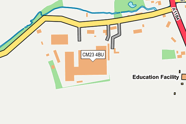
CM23 4BU is located in the Sawbridgeworth electoral ward, within the local authority district of East Hertfordshire and the English Parliamentary constituency of Hertford and Stortford. The Sub Integrated Care Board (ICB) Location is NHS Hertfordshire and West Essex ICB - 06K and the police force is Hertfordshire. This postcode has been in use since January 1980.


GetTheData
Source: OS OpenMap – Local (Ordnance Survey)
Source: OS VectorMap District (Ordnance Survey)
Licence: Open Government Licence (requires attribution)
| Easting | 548390 |
| Northing | 217311 |
| Latitude | 51.834702 |
| Longitude | 0.152255 |
GetTheData
Source: Open Postcode Geo
Licence: Open Government Licence
| Country | England |
| Postcode District | CM23 |
➜ See where CM23 is on a map ➜ Where is Spellbrook? | |
GetTheData
Source: Land Registry Price Paid Data
Licence: Open Government Licence
Elevation or altitude of CM23 4BU as distance above sea level:
| Metres | Feet | |
|---|---|---|
| Elevation | 60m | 197ft |
Elevation is measured from the approximate centre of the postcode, to the nearest point on an OS contour line from OS Terrain 50, which has contour spacing of ten vertical metres.
➜ How high above sea level am I? Find the elevation of your current position using your device's GPS.
GetTheData
Source: Open Postcode Elevation
Licence: Open Government Licence
| Ward | Sawbridgeworth |
| Constituency | Hertford And Stortford |
GetTheData
Source: ONS Postcode Database
Licence: Open Government Licence
| Spellbrook Lane (A1184) | Spellbrook | 462m |
| Tednambury Farm (London Road) | Spellbrook | 563m |
| Spellbrook Lane (A1184) | Spellbrook | 600m |
| Tednambury Farm (Spellbrook) | Spellbrook | 676m |
| Thorley Wash Grange (A1184) | Spellbrook | 848m |
| Sawbridgeworth Station | 2.3km |
| Bishops Stortford Station | 3.7km |
| Harlow Mill Station | 5.1km |
GetTheData
Source: NaPTAN
Licence: Open Government Licence
GetTheData
Source: ONS Postcode Database
Licence: Open Government Licence


➜ Get more ratings from the Food Standards Agency
GetTheData
Source: Food Standards Agency
Licence: FSA terms & conditions
| Last Collection | |||
|---|---|---|---|
| Location | Mon-Fri | Sat | Distance |
| Bullfields | 17:15 | 11:40 | 1,769m |
| Cambridge Road | 17:30 | 11:45 | 2,115m |
| West Road | 17:15 | 12:00 | 2,133m |
GetTheData
Source: Dracos
Licence: Creative Commons Attribution-ShareAlike
The below table lists the International Territorial Level (ITL) codes (formerly Nomenclature of Territorial Units for Statistics (NUTS) codes) and Local Administrative Units (LAU) codes for CM23 4BU:
| ITL 1 Code | Name |
|---|---|
| TLH | East |
| ITL 2 Code | Name |
| TLH2 | Bedfordshire and Hertfordshire |
| ITL 3 Code | Name |
| TLH23 | Hertfordshire CC |
| LAU 1 Code | Name |
| E07000242 | East Hertfordshire |
GetTheData
Source: ONS Postcode Directory
Licence: Open Government Licence
The below table lists the Census Output Area (OA), Lower Layer Super Output Area (LSOA), and Middle Layer Super Output Area (MSOA) for CM23 4BU:
| Code | Name | |
|---|---|---|
| OA | E00119371 | |
| LSOA | E01023499 | East Hertfordshire 011A |
| MSOA | E02004888 | East Hertfordshire 011 |
GetTheData
Source: ONS Postcode Directory
Licence: Open Government Licence
| CM23 4AY | Spellbrook Lane West | 131m |
| CM23 4BA | London Road | 338m |
| CM23 4AX | London Road | 418m |
| CM23 4RB | Oram Court | 434m |
| CM22 7SE | Spellbrook Lane East | 521m |
| CM23 4BB | Tednambury | 598m |
| CM23 4AU | London Road | 672m |
| CM21 0NB | Spellbrook Lane | 720m |
| CM22 7SG | Dell Lane | 742m |
| CM23 4BD | Tednambury | 791m |
GetTheData
Source: Open Postcode Geo; Land Registry Price Paid Data
Licence: Open Government Licence