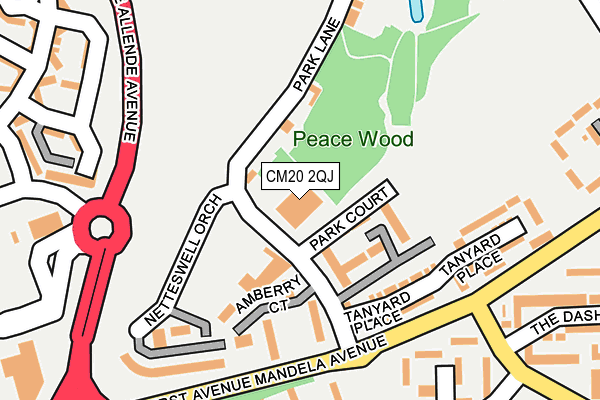
CM20 2QJ is located in the Netteswell electoral ward, within the local authority district of Harlow and the English Parliamentary constituency of Harlow. The Sub Integrated Care Board (ICB) Location is NHS Hertfordshire and West Essex ICB - 07H and the police force is Essex. This postcode has been in use since June 1981.


GetTheData
Source: OS OpenMap – Local (Ordnance Survey)
Source: OS VectorMap District (Ordnance Survey)
Licence: Open Government Licence (requires attribution)
| Easting | 544886 |
| Northing | 210544 |
| Latitude | 51.774820 |
| Longitude | 0.098611 |
GetTheData
Source: Open Postcode Geo
Licence: Open Government Licence
| Country | England |
| Postcode District | CM20 |
➜ See where CM20 is on a map ➜ Where is Harlow? | |
GetTheData
Source: Land Registry Price Paid Data
Licence: Open Government Licence
Elevation or altitude of CM20 2QJ as distance above sea level:
| Metres | Feet | |
|---|---|---|
| Elevation | 60m | 197ft |
Elevation is measured from the approximate centre of the postcode, to the nearest point on an OS contour line from OS Terrain 50, which has contour spacing of ten vertical metres.
➜ How high above sea level am I? Find the elevation of your current position using your device's GPS.
GetTheData
Source: Open Postcode Elevation
Licence: Open Government Licence
| Ward | Netteswell |
| Constituency | Harlow |
GetTheData
Source: ONS Postcode Database
Licence: Open Government Licence
| Park Lane (First Avenue) | Harlow | 176m |
| Sports Centre (Allende Avenue) | Harlow | 196m |
| Netteswell Orchard (Fifth Avenue) | Harlow | 220m |
| Park Lane (First Avenue) | Harlow | 228m |
| Sainsburys Store (Fifth Avenue) | Harlow | 282m |
| Harlow Town Station | 0.7km |
| Harlow Mill Station | 2.9km |
| Roydon Station | 4.3km |
GetTheData
Source: NaPTAN
Licence: Open Government Licence
GetTheData
Source: ONS Postcode Database
Licence: Open Government Licence


➜ Get more ratings from the Food Standards Agency
GetTheData
Source: Food Standards Agency
Licence: FSA terms & conditions
| Last Collection | |||
|---|---|---|---|
| Location | Mon-Fri | Sat | Distance |
| River Mill | 17:15 | 12:00 | 655m |
| Tanys Dell | 17:15 | 12:00 | 862m |
| Pittmans Field | 17:45 | 12:00 | 901m |
GetTheData
Source: Dracos
Licence: Creative Commons Attribution-ShareAlike
The below table lists the International Territorial Level (ITL) codes (formerly Nomenclature of Territorial Units for Statistics (NUTS) codes) and Local Administrative Units (LAU) codes for CM20 2QJ:
| ITL 1 Code | Name |
|---|---|
| TLH | East |
| ITL 2 Code | Name |
| TLH3 | Essex |
| ITL 3 Code | Name |
| TLH35 | West Essex |
| LAU 1 Code | Name |
| E07000073 | Harlow |
GetTheData
Source: ONS Postcode Directory
Licence: Open Government Licence
The below table lists the Census Output Area (OA), Lower Layer Super Output Area (LSOA), and Middle Layer Super Output Area (MSOA) for CM20 2QJ:
| Code | Name | |
|---|---|---|
| OA | E00111008 | |
| LSOA | E01021851 | Harlow 003C |
| MSOA | E02004546 | Harlow 003 |
GetTheData
Source: ONS Postcode Directory
Licence: Open Government Licence
| CM20 2PY | Park Court | 84m |
| CM20 2QH | Park Lane | 94m |
| CM20 2PZ | Park Court | 95m |
| CM20 2PX | Amberry Court | 127m |
| CM20 2FF | Tanyard Place | 173m |
| CM20 2QN | 202m | |
| CM20 2QW | Netteswell Orchard | 212m |
| CM20 3RP | The Dashes | 232m |
| CM20 3QL | The Hides | 235m |
| CM20 2QQ | Park Lane | 256m |
GetTheData
Source: Open Postcode Geo; Land Registry Price Paid Data
Licence: Open Government Licence