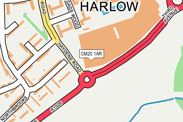
CM20 1AR is located in the Toddbrook electoral ward, within the local authority district of Harlow and the English Parliamentary constituency of Harlow. The Sub Integrated Care Board (ICB) Location is NHS Hertfordshire and West Essex ICB - 07H and the police force is Essex. This postcode has been in use since November 2003.


GetTheData
Source: OS OpenMap – Local (Ordnance Survey)
Source: OS VectorMap District (Ordnance Survey)
Licence: Open Government Licence (requires attribution)
| Easting | 544551 |
| Northing | 209536 |
| Latitude | 51.765855 |
| Longitude | 0.093367 |
GetTheData
Source: Open Postcode Geo
Licence: Open Government Licence
| Country | England |
| Postcode District | CM20 |
➜ See where CM20 is on a map ➜ Where is Harlow? | |
GetTheData
Source: Land Registry Price Paid Data
Licence: Open Government Licence
Elevation or altitude of CM20 1AR as distance above sea level:
| Metres | Feet | |
|---|---|---|
| Elevation | 70m | 230ft |
Elevation is measured from the approximate centre of the postcode, to the nearest point on an OS contour line from OS Terrain 50, which has contour spacing of ten vertical metres.
➜ How high above sea level am I? Find the elevation of your current position using your device's GPS.
GetTheData
Source: Open Postcode Elevation
Licence: Open Government Licence
| Ward | Toddbrook |
| Constituency | Harlow |
GetTheData
Source: ONS Postcode Database
Licence: Open Government Licence
| Playhouse Square (Haydens Road) | Harlow Town Centre | 209m |
| Third Avenue | Harlow | 343m |
| Haydens Road | Harlow Town Centre | 379m |
| Leisure Centre (Second Avenue) | Harlow | 410m |
| Third Avenue | Harlow | 464m |
| Harlow Town Station | 1.7km |
| Harlow Mill Station | 3.8km |
| Roydon Station | 4.1km |
GetTheData
Source: NaPTAN
Licence: Open Government Licence
GetTheData
Source: ONS Postcode Database
Licence: Open Government Licence


➜ Get more ratings from the Food Standards Agency
GetTheData
Source: Food Standards Agency
Licence: FSA terms & conditions
| Last Collection | |||
|---|---|---|---|
| Location | Mon-Fri | Sat | Distance |
| Tanys Dell | 17:15 | 12:00 | 843m |
| Hollyfield | 17:15 | 12:00 | 1,122m |
| Rectory Wood | 17:15 | 12:00 | 1,186m |
GetTheData
Source: Dracos
Licence: Creative Commons Attribution-ShareAlike
The below table lists the International Territorial Level (ITL) codes (formerly Nomenclature of Territorial Units for Statistics (NUTS) codes) and Local Administrative Units (LAU) codes for CM20 1AR:
| ITL 1 Code | Name |
|---|---|
| TLH | East |
| ITL 2 Code | Name |
| TLH3 | Essex |
| ITL 3 Code | Name |
| TLH35 | West Essex |
| LAU 1 Code | Name |
| E07000073 | Harlow |
GetTheData
Source: ONS Postcode Directory
Licence: Open Government Licence
The below table lists the Census Output Area (OA), Lower Layer Super Output Area (LSOA), and Middle Layer Super Output Area (MSOA) for CM20 1AR:
| Code | Name | |
|---|---|---|
| OA | E00111094 | |
| LSOA | E01021868 | Harlow 007B |
| MSOA | E02004550 | Harlow 007 |
GetTheData
Source: ONS Postcode Directory
Licence: Open Government Licence
| CM19 4DQ | Northbrooks | 127m |
| CM20 1JQ | Dads Wood | 134m |
| CM19 4DF | Northbrooks | 168m |
| CM20 1JL | Dads Wood | 170m |
| CM20 1JG | Dads Wood | 210m |
| CM19 4DA | Northbrooks | 213m |
| CM19 4DG | Northbrooks | 221m |
| CM20 1AQ | The Water Gardens | 222m |
| CM19 4DH | Northbrooks | 228m |
| CM19 4DB | Northbrooks | 262m |
GetTheData
Source: Open Postcode Geo; Land Registry Price Paid Data
Licence: Open Government Licence