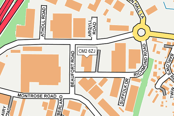
CM2 6ZJ is located in the Chelmer Village and Beaulieu Park electoral ward, within the local authority district of Chelmsford and the English Parliamentary constituency of Chelmsford. The Sub Integrated Care Board (ICB) Location is NHS Mid and South Essex ICB - 06Q and the police force is Essex. This postcode has been in use since April 2016.


GetTheData
Source: OS OpenMap – Local (Ordnance Survey)
Source: OS VectorMap District (Ordnance Survey)
Licence: Open Government Licence (requires attribution)
| Easting | 573076 |
| Northing | 207975 |
| Latitude | 51.743745 |
| Longitude | 0.505539 |
GetTheData
Source: Open Postcode Geo
Licence: Open Government Licence
| Country | England |
| Postcode District | CM2 |
➜ See where CM2 is on a map ➜ Where is Chelmsford? | |
GetTheData
Source: Land Registry Price Paid Data
Licence: Open Government Licence
Elevation or altitude of CM2 6ZJ as distance above sea level:
| Metres | Feet | |
|---|---|---|
| Elevation | 40m | 131ft |
Elevation is measured from the approximate centre of the postcode, to the nearest point on an OS contour line from OS Terrain 50, which has contour spacing of ten vertical metres.
➜ How high above sea level am I? Find the elevation of your current position using your device's GPS.
GetTheData
Source: Open Postcode Elevation
Licence: Open Government Licence
| Ward | Chelmer Village And Beaulieu Park |
| Constituency | Chelmsford |
GetTheData
Source: ONS Postcode Database
Licence: Open Government Licence
| New Dukes Way | Chelmer Village | 113m |
| New Dukes Way | Chelmer Village | 115m |
| Cuton Hall Lane | Chelmer Village | 266m |
| Cuton Hall Lane | Chelmer Village | 273m |
| Chelmer Village Way | Chelmer Village | 321m |
| Chelmsford Station | 2.7km |
GetTheData
Source: NaPTAN
Licence: Open Government Licence
GetTheData
Source: ONS Postcode Database
Licence: Open Government Licence

➜ Get more ratings from the Food Standards Agency
GetTheData
Source: Food Standards Agency
Licence: FSA terms & conditions
| Last Collection | |||
|---|---|---|---|
| Location | Mon-Fri | Sat | Distance |
| Essex Distribution Centre | 265m | ||
| Chelmer Village Way | 17:40 | 12:00 | 456m |
| Upper Springfield Road | 17:30 | 11:30 | 696m |
GetTheData
Source: Dracos
Licence: Creative Commons Attribution-ShareAlike
The below table lists the International Territorial Level (ITL) codes (formerly Nomenclature of Territorial Units for Statistics (NUTS) codes) and Local Administrative Units (LAU) codes for CM2 6ZJ:
| ITL 1 Code | Name |
|---|---|
| TLH | East |
| ITL 2 Code | Name |
| TLH3 | Essex |
| ITL 3 Code | Name |
| TLH36 | Heart of Essex |
| LAU 1 Code | Name |
| E07000070 | Chelmsford |
GetTheData
Source: ONS Postcode Directory
Licence: Open Government Licence
The below table lists the Census Output Area (OA), Lower Layer Super Output Area (LSOA), and Middle Layer Super Output Area (MSOA) for CM2 6ZJ:
| Code | Name | |
|---|---|---|
| OA | E00109459 | |
| LSOA | E01021544 | Chelmsford 008A |
| MSOA | E02004492 | Chelmsford 008 |
GetTheData
Source: ONS Postcode Directory
Licence: Open Government Licence
| CM2 6PB | Cuton Lane | 205m |
| CM2 6TD | Chelmer Village Way | 245m |
| CM2 6SW | Murrell Lock | 278m |
| CM2 6SN | Barlows Reach | 279m |
| CM2 6SP | Twin Oaks | 355m |
| CM2 6QE | Sheppard Drive | 362m |
| CM2 6TY | Burton Place | 368m |
| CM2 6QA | Barlows Reach | 381m |
| CM2 6XW | Buckingham Court | 383m |
| CM2 6QF | Wilkinsons Mead | 383m |
GetTheData
Source: Open Postcode Geo; Land Registry Price Paid Data
Licence: Open Government Licence