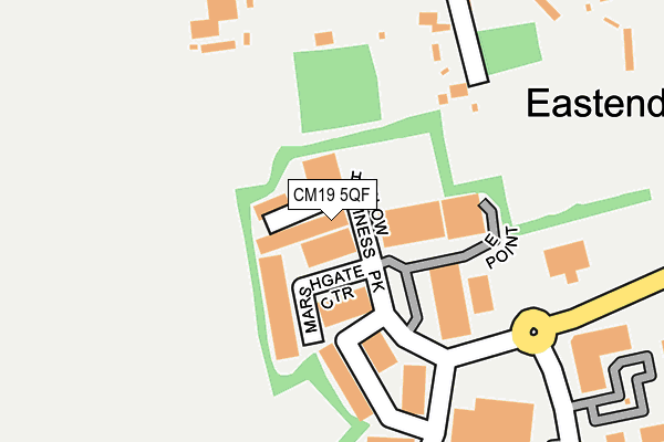
CM19 5QF lies on Parkway in Harlow. CM19 5QF is located in the Little Parndon and Hare Street electoral ward, within the local authority district of Harlow and the English Parliamentary constituency of Harlow. The Sub Integrated Care Board (ICB) Location is NHS Hertfordshire and West Essex ICB - 07H and the police force is Essex. This postcode has been in use since December 2002.


GetTheData
Source: OS OpenMap – Local (Ordnance Survey)
Source: OS VectorMap District (Ordnance Survey)
Licence: Open Government Licence (requires attribution)
| Easting | 541956 |
| Northing | 209924 |
| Latitude | 51.769999 |
| Longitude | 0.055920 |
GetTheData
Source: Open Postcode Geo
Licence: Open Government Licence
| Street | Parkway |
| Town/City | Harlow |
| Country | England |
| Postcode District | CM19 |
➜ See where CM19 is on a map ➜ Where is Harlow? | |
GetTheData
Source: Land Registry Price Paid Data
Licence: Open Government Licence
Elevation or altitude of CM19 5QF as distance above sea level:
| Metres | Feet | |
|---|---|---|
| Elevation | 60m | 197ft |
Elevation is measured from the approximate centre of the postcode, to the nearest point on an OS contour line from OS Terrain 50, which has contour spacing of ten vertical metres.
➜ How high above sea level am I? Find the elevation of your current position using your device's GPS.
GetTheData
Source: Open Postcode Elevation
Licence: Open Government Licence
| Ward | Little Parndon And Hare Street |
| Constituency | Harlow |
GetTheData
Source: ONS Postcode Database
Licence: Open Government Licence
CAVENDISH HOUSE, PARKWAY, HARLOW, CM19 5QF 2023 2 MAR £2,125,000 |
GetTheData
Source: HM Land Registry Price Paid Data
Licence: Contains HM Land Registry data © Crown copyright and database right 2025. This data is licensed under the Open Government Licence v3.0.
| Village Hall (Harlow Road) | Roydon | 808m |
| Village Hall (Harlow Road) | Roydon | 815m |
| Pitney Bowes (Elizabeth Way) | Pinnacles | 834m |
| Pitney Bowes (Elizabeth Way) | Pinnacles | 845m |
| Cawley Hatch (Elizabeth Way) | Pinnacles | 920m |
| Roydon Station | 1.5km |
| Harlow Town Station | 3km |
| Rye House Station | 3.5km |
GetTheData
Source: NaPTAN
Licence: Open Government Licence
| Median download speed | 6.6Mbps |
| Average download speed | 6.3Mbps |
| Maximum download speed | 7.68Mbps |
| Median upload speed | 1.0Mbps |
| Average upload speed | 1.0Mbps |
| Maximum upload speed | 1.09Mbps |
GetTheData
Source: Ofcom
Licence: Ofcom Terms of Use (requires attribution)
Estimated total energy consumption in CM19 5QF by fuel type, 2015.
| Consumption (kWh) | 42,801 |
|---|---|
| Meter count | 7 |
| Mean (kWh/meter) | 6,114 |
| Median (kWh/meter) | 4,286 |
GetTheData
Source: Postcode level gas estimates: 2015 (experimental)
Source: Postcode level electricity estimates: 2015 (experimental)
Licence: Open Government Licence
GetTheData
Source: ONS Postcode Database
Licence: Open Government Licence


➜ Get more ratings from the Food Standards Agency
GetTheData
Source: Food Standards Agency
Licence: FSA terms & conditions
| Last Collection | |||
|---|---|---|---|
| Location | Mon-Fri | Sat | Distance |
| Epping Road | 16:40 | 09:50 | 1,294m |
| Hare Street | 17:15 | 12:00 | 1,361m |
| Roydon Station | 16:45 | 09:00 | 1,457m |
GetTheData
Source: Dracos
Licence: Creative Commons Attribution-ShareAlike
The below table lists the International Territorial Level (ITL) codes (formerly Nomenclature of Territorial Units for Statistics (NUTS) codes) and Local Administrative Units (LAU) codes for CM19 5QF:
| ITL 1 Code | Name |
|---|---|
| TLH | East |
| ITL 2 Code | Name |
| TLH3 | Essex |
| ITL 3 Code | Name |
| TLH35 | West Essex |
| LAU 1 Code | Name |
| E07000073 | Harlow |
GetTheData
Source: ONS Postcode Directory
Licence: Open Government Licence
The below table lists the Census Output Area (OA), Lower Layer Super Output Area (LSOA), and Middle Layer Super Output Area (MSOA) for CM19 5QF:
| Code | Name | |
|---|---|---|
| OA | E00110956 | |
| LSOA | E01021840 | Harlow 004B |
| MSOA | E02004547 | Harlow 004 |
GetTheData
Source: ONS Postcode Directory
Licence: Open Government Licence
| CM19 5FR | Parkway | 121m |
| CM19 5QB | Greenway | 173m |
| CM19 5DT | Roydon Road | 206m |
| CM19 5DS | Roydon Road | 250m |
| CM19 5QJ | Greenway | 301m |
| CM19 5BZ | Roydenbury Industrial Estate | 476m |
| CM19 5HE | Harlow Road | 515m |
| CM19 5DU | Roydon Road | 531m |
| CM19 5LR | Little Brook Road | 638m |
| CM19 5GX | Stadium Way | 662m |
GetTheData
Source: Open Postcode Geo; Land Registry Price Paid Data
Licence: Open Government Licence