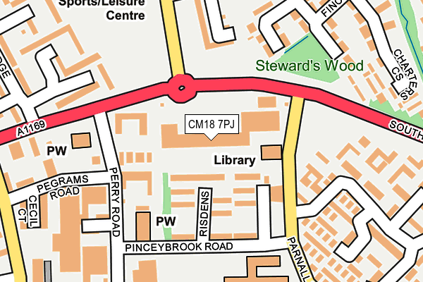
CM18 7PJ lies on Staple Tye Shopping Centre in Harlow. CM18 7PJ is located in the Staple Tye electoral ward, within the local authority district of Harlow and the English Parliamentary constituency of Harlow. The Sub Integrated Care Board (ICB) Location is NHS Hertfordshire and West Essex ICB - 07H and the police force is Essex. This postcode has been in use since December 1994.


GetTheData
Source: OS OpenMap – Local (Ordnance Survey)
Source: OS VectorMap District (Ordnance Survey)
Licence: Open Government Licence (requires attribution)
| Easting | 544497 |
| Northing | 208127 |
| Latitude | 51.753203 |
| Longitude | 0.091973 |
GetTheData
Source: Open Postcode Geo
Licence: Open Government Licence
| Street | Staple Tye Shopping Centre |
| Town/City | Harlow |
| Country | England |
| Postcode District | CM18 |
➜ See where CM18 is on a map ➜ Where is Harlow? | |
GetTheData
Source: Land Registry Price Paid Data
Licence: Open Government Licence
Elevation or altitude of CM18 7PJ as distance above sea level:
| Metres | Feet | |
|---|---|---|
| Elevation | 70m | 230ft |
Elevation is measured from the approximate centre of the postcode, to the nearest point on an OS contour line from OS Terrain 50, which has contour spacing of ten vertical metres.
➜ How high above sea level am I? Find the elevation of your current position using your device's GPS.
GetTheData
Source: Open Postcode Elevation
Licence: Open Government Licence
| Ward | Staple Tye |
| Constituency | Harlow |
GetTheData
Source: ONS Postcode Database
Licence: Open Government Licence
| Shopping Centre (Parnall Road) | Staple Tye | 117m |
| Shopping Centre (Parnall Road) | Staple Tye | 145m |
| Gpca (Abercrombie Way) | Passmores | 189m |
| Bp Garage (Southern Way) | Staple Tye | 196m |
| Bp Garage (Southern Way) | Staple Tye | 250m |
| Harlow Town Station | 3.1km |
| Roydon Station | 4.6km |
| Harlow Mill Station | 5km |
GetTheData
Source: NaPTAN
Licence: Open Government Licence
| Median download speed | 6.5Mbps |
| Average download speed | 5.9Mbps |
| Maximum download speed | 7.31Mbps |
| Median upload speed | 1.0Mbps |
| Average upload speed | 1.0Mbps |
| Maximum upload speed | 1.11Mbps |
GetTheData
Source: Ofcom
Licence: Ofcom Terms of Use (requires attribution)
GetTheData
Source: ONS Postcode Database
Licence: Open Government Licence


➜ Get more ratings from the Food Standards Agency
GetTheData
Source: Food Standards Agency
Licence: FSA terms & conditions
| Last Collection | |||
|---|---|---|---|
| Location | Mon-Fri | Sat | Distance |
| Brockles Mead | 17:00 | 12:00 | 370m |
| Hollyfield | 17:15 | 12:00 | 566m |
| Five Acres | 17:30 | 12:15 | 689m |
GetTheData
Source: Dracos
Licence: Creative Commons Attribution-ShareAlike
The below table lists the International Territorial Level (ITL) codes (formerly Nomenclature of Territorial Units for Statistics (NUTS) codes) and Local Administrative Units (LAU) codes for CM18 7PJ:
| ITL 1 Code | Name |
|---|---|
| TLH | East |
| ITL 2 Code | Name |
| TLH3 | Essex |
| ITL 3 Code | Name |
| TLH35 | West Essex |
| LAU 1 Code | Name |
| E07000073 | Harlow |
GetTheData
Source: ONS Postcode Directory
Licence: Open Government Licence
The below table lists the Census Output Area (OA), Lower Layer Super Output Area (LSOA), and Middle Layer Super Output Area (MSOA) for CM18 7PJ:
| Code | Name | |
|---|---|---|
| OA | E00111061 | |
| LSOA | E01021859 | Harlow 010C |
| MSOA | E02004553 | Harlow 010 |
GetTheData
Source: ONS Postcode Directory
Licence: Open Government Licence
| CM18 7NH | Risdens | 50m |
| CM18 7PP | Parnall Road | 88m |
| CM18 7NJ | Risdens | 99m |
| CM18 7NL | Risdens | 107m |
| CM18 7NT | Long Banks | 161m |
| CM19 4NS | Shawbridge | 196m |
| CM18 6UB | Finchmoor | 216m |
| CM18 7PQ | Long Banks | 216m |
| CM18 6UF | Finchmoor | 217m |
| CM19 4NT | Shawbridge | 219m |
GetTheData
Source: Open Postcode Geo; Land Registry Price Paid Data
Licence: Open Government Licence